
Everest Region (Khumbu), Nepal
Everest Base Camp Trek
Fourteen days through Sherpa country to the foot of the highest mountain on earth, finishing at Kala Patthar (5,545 m) — which is where you actually see Everest.
Package Overview
Best Time to Visit
March to May, late September to November
Group Discount
10% OFF
for groups of 4 or more
Guided & Permitted
Licensed, insured guide and all trekking permits included
You cannot see Everest from Everest Base Camp
This is the single most useful thing to know before you book, and almost no operator page says it. From Base Camp itself the mountain is hidden behind the Nuptse wall. You stand on the moraine at 5,364 m, below the Khumbu Icefall, and the summit is not in the view.
The mountain appears from Kala Patthar, a 5,545 m shoulder above Gorak Shep, which you climb before dawn the following morning. From there the entire south-west face is in front of you, with Nuptse and Changtse alongside, catching the light first.
Both days matter, and they matter for different reasons. Base Camp is about having walked there — in spring it is a city of expedition tents on the ice with the glacier audibly moving underneath. Kala Patthar is the photograph. An itinerary that includes one and not the other has sold you half the trek.
Fourteen days, and what a twelve-day quote has removed
You will see this trek advertised at ten, eleven and twelve days. The mountains do not move, so something else has been taken out, and it is nearly always one or both acclimatisation days.
| Day | What it does | First thing cut in a short quote |
|---|---|---|
| Namche, 3,440 m | Climb to about 3,880 m, sleep low | Yes |
| Dingboche, 4,410 m | Climb Nangkartshang to about 5,080 m, sleep low | Yes |
| Spare day at the end | Absorbs a cancelled Lukla flight | Yes |
Those are the days that decide whether you finish. Acclimatisation happens on a schedule you cannot negotiate with, and no level of fitness substitutes for it — if anything, strong walkers are at more risk, because they can outrun their own adaptation and push through the early warnings.
When you compare our price against a cheaper one, compare the day count first and ask which nights are missing. That is where the difference is.
The Lukla flight, and the Ramechhap catch
Here is the operational detail that catches people out and that a lot of pages describe as "sometimes".
| When you travel | You fly from | What that means |
|---|---|---|
| 15 March – 15 May | Manthali, Ramechhap | 4–5 hour drive from Kathmandu, leaving around 2am |
| 25 September – 30 November | Manthali, Ramechhap | Same — and this covers the whole autumn season |
| December – early March, June – late September | Kathmandu | A 30–35 minute flight from the domestic terminal |
In peak season Kathmandu's airport cannot absorb the morning Lukla traffic, so the Civil Aviation Authority moves the whole operation to a regional strip at Manthali. From there the flight is shorter — fifteen to twenty minutes — but you are on a bus in the dark first.
It is not a problem. It is a thing to be told before you book rather than the night before. If your trek falls in either window, build the pre-dawn start into how you plan your last day in Kathmandu.
Whichever airport you leave from, cancellations are routine rather than exceptional. In cloud, nothing flies. We keep a spare day at the end, and we would repeat the standard advice: never book an international departure for the evening you are due out of Lukla.
What the walking is actually like
There is no technical ground on this trek, no rope, no equipment beyond boots and poles. The trail is the best-maintained in Nepal. The difficulty is altitude and repetition.
| Stage | Hours | The hard part |
|---|---|---|
| Lukla to Phakding | 3–4 | Nothing — it is downhill |
| Phakding to Namche | 5–6 | 600 m of climbing in the final stretch, in afternoon warmth |
| Namche to Tengboche | 5–6 | A long drop to the river, then all of it climbed back |
| Tengboche to Dingboche | 5–6 | Thin air rather than gradient; the trees end here |
| Dingboche to Lobuche | 5–6 | The memorial cairns at Thukla, and the cold |
| Base Camp day | 7–8 | Length, and sleeping afterwards at 5,170 m |
| Kala Patthar | 2 up | The steepest two hours of the trek, in the dark, at 5,500 m |
The day people brace for is Base Camp. The day that actually tests them is the night at Gorak Shep afterwards — the highest, coldest night of the trip, where almost nobody sleeps properly, followed by a 4am start.
Spring and autumn are different trips
Most pages treat the seasons as a weather question. The bigger difference is what is at Base Camp when you get there.
April into early May puts you there during the summit push. Several hundred tents sit on the ice, teams rotate up through the icefall, and helicopters shuttle loads in and out all morning. You are standing in the middle of a working operation rather than looking at an empty glacier. The price is company on the trail and softer light on the peaks.
Late September into November reverses both. The glacier is bare — prayer flags, moraine, silence — which strikes some visitors as the more powerful version and leaves others faintly deflated. Visibility is at its annual best, and the nights at Lobuche and Gorak Shep are markedly colder.
If you care about the photograph, come in autumn. If you want to see the mountain being climbed, come in April. That is genuinely the whole decision.
What the price covers, and what it does not
Both permits are in the quoted figure, as are the Lukla flights in both directions, every night's lodging, all three meals a day for the full fourteen days, and a licensed guide whose own wages, insurance, food and bed are our cost rather than yours.
What you pay for separately on the trail is the short list that catches people out: charging a device, a bucket of hot water, wifi, and anything in a bottle. Those are the items that were carried up on somebody's back, so they cost markedly more at Gorak Shep than at Phakding.
Bring the whole trek's spending money as rupees in small notes before you leave the city. Nothing above Namche takes a card, and its machines empty out in season. The Everest region guide breaks down what the Khumbu costs generally; the pricing article explains what a cheap quote has left out.
How we manage the altitude on this trip
Two full acclimatisation days are built in, at Namche and Dingboche, each spent climbing several hundred metres and returning to sleep at the same height. That pattern is the whole plan, and it is why this runs to fourteen days.
Your guide carries a pulse oximeter and takes a reading twice daily once you are past 4,000 m. One number on its own means very little. A downward trend across three days means a great deal, and it is what the guide is watching for.
Ordinary symptoms — a headache, broken sleep, no appetite — turn up above 3,500 m in a good proportion of trekkers and usually clear after a day at the same height. Two signs do not get that treatment: unsteadiness on your feet and breathlessness while sitting still. Either one means going down that hour, in the dark if it comes to it.
On day ten the route passes the Himalayan Rescue Association post, whose afternoon talk is free and worth the hour. Our guides decide when a trek ends, with the company behind them, and are told in plain terms that calling it is competent rather than a failure. Cover for helicopter evacuation to 6,000 m is a condition of joining this trip and we check the policy before you fly. There is more in our altitude guide.
Flying out by helicopter
Many people ask, so here is the straight answer. A helicopter from Gorak Shep or Pheriche to Lukla or Kathmandu can be arranged, at significant additional cost, and it removes three to four days of descent.
We will book it if you want it. We will also say that the walk down is the part where the air thickens hour by hour, the trees come back, and most people feel physically wonderful — and that it is cheaper and, for most, better. A helicopter is the right answer for a genuine medical need or a hard deadline, not by default.
Who this trek suits
Anyone who can walk five to seven hours on consecutive days and has sixteen to eighteen days from leaving home to getting back — the fourteen here plus international flights and a buffer. No previous altitude experience is needed, and a reasonably fit first-time trekker who trains on hills will manage it.
It suits you badly on two counts. If your dates have no give in them, the Lukla flight will eventually punish that. And if sharing a trail bothers you, October here is busy in a way no amount of early starts fixes. For the first, Langtang needs no flight at all and still reaches a 4,985 m viewpoint. For the second, the region guide sets Gokyo and the Three Passes against this route.
If you want a summit rather than a viewpoint, Island Peak and Lobuche East both build on this same acclimatisation profile.
Where this trek goes
- Kathmandu Valley — Seven UNESCO Monument Zones within an hour of each other
Related activities: Trekking in Nepal, Photography Tours in Nepal.
Or compare every trip we run: all trekking and tour packages.
Trip Highlights
Kala Patthar (5,545 m) — where Everest is actually visible, in full
Everest Base Camp (5,364 m) beneath the Khumbu Icefall
Namche Bazaar, the trading town that supplies the whole Khumbu
Tengboche monastery, with Ama Dablam framed behind it
Two full acclimatisation days, at Namche and Dingboche
Sagarmatha National Park, a UNESCO World Heritage site since 1979
Live Weather
Detailed Itinerary
1
Day 1: Arrive in Kathmandu (1,400 m)
Airport transfer and an afternoon briefing with your guide, covering the route, the altitude plan and which airport you will be flying from — in peak season that means a pre-dawn drive to Ramechhap rather than a Kathmandu departure. Time to rent a down jacket or sleeping bag in Thamel if you need one, and a full kit check before anything is packed.
2
Day 2: Fly to Lukla (2,840 m), trek to Phakding (2,610 m)
The flight onto the sloping airstrip at Lukla, from Kathmandu or Manthali depending on the season. Then three to four hours of easy downhill walking beside the Dudh Koshi to Phakding. A deliberately short first day: you have just flown into one of the more dramatic airfields in the world and there is nothing to gain from adding distance to it.
3
Day 3: Phakding to Namche Bazaar (3,440 m)
Five to six hours, crossing and re-crossing the river on suspension bridges, with Sagarmatha National Park permits checked at Monjo. The last stretch is the first real work of the trek — around 600 m of climbing to Namche, in the warmth of the afternoon. Everest appears briefly through the trees about an hour below the town. Namche is built into a horseshoe bowl and has bakeries, gear shops and the last dependable cash machines.
4
Day 4: Namche Bazaar — acclimatisation day
Not a rest day. We climb to around 3,880 m at the Everest View Hotel and Khumjung and come back down to sleep, which is the mechanism that makes the rest of the trek possible. The afternoon is free: the Sherpa Culture Museum is worth an hour, and this is the last place to fix any gear problem before committing to the high valley.
5
Day 5: Namche Bazaar to Tengboche (3,860 m)
Five to six hours. A level contour with big views, then a long drop to the river at Phunki Thenga and all of it climbed back up through rhododendron to Tengboche. The monastery here is the religious centre of the Khumbu, and the courtyard view — Ama Dablam, Everest, Lhotse and Nuptse together — is among the most photographed in Nepal. The evening puja is open to visitors when it runs.
6
Day 6: Tengboche to Dingboche (4,410 m)
Five to six hours with the treeline falling away behind you. Rhododendron becomes scrub, scrub becomes grazing, and by Dingboche there is no vegetation worth the name — a village of stone-walled potato fields. Ama Dablam dominates the whole morning. The first night above 4,400 m, and the first time most people notice their breathing on the stairs.
7
Day 7: Dingboche — acclimatisation day
A climb to Nangkartshang at around 5,080 m and back down to sleep. It is a hard afternoon and the most valuable one of the trek: for most clients it is the first time above 5,000 m in their lives, with Makalu visible to the east from the top on a clear day. Rest and eat afterwards — the next three days are the serious ones.
8
Day 8: Dingboche to Lobuche (4,940 m)
Five to six hours up the Khumbu valley to Thukla and then the steep pull onto the pass, where memorial cairns stand for climbers lost on these mountains — some of the names widely known. It is a quiet part of the walk and an appropriate one to be passing through here. Lobuche is a cold cluster of lodges on the moraine.
9
Day 9: Lobuche to Everest Base Camp (5,364 m), night at Gorak Shep (5,170 m)
Seven to eight hours. Along the Khumbu glacier moraine to Gorak Shep, then out across the ice to Base Camp itself, under the Khumbu Icefall — in spring a city of expedition tents, in autumn an empty moraine field with prayer flags. Everest is hidden behind Nuptse from here; that view comes tomorrow. Back to Gorak Shep for the highest and coldest night of the trip, which almost nobody sleeps through.
10
Day 10: Kala Patthar (5,545 m) at dawn, descend to Pheriche (4,240 m)
Away around 4am for the two-hour climb to Kala Patthar — the steepest sustained effort of the trek, at the highest altitude you will reach. From the top the whole south-west face of Everest is in front of you, catching the sun before anything else. Then the long descent, five to six hours, to Pheriche. The Himalayan Rescue Association aid post here runs a free altitude talk most afternoons.
11
Day 11: Pheriche to Namche Bazaar (3,440 m)
Six to seven hours retracing the valley through Pangboche and Tengboche. The air thickens noticeably with every hour and most people describe feeling physically better by mid-morning. Worth stopping at Pangboche gompa, the oldest in the Khumbu, which groups walk straight past on the way up because they are concentrating on the altitude.
12
Day 12: Namche Bazaar to Lukla (2,840 m)
Six to seven hours back down the Dudh Koshi valley, with the final hour an unwelcome climb into Lukla that nobody warns you about. The last walking day. Settle up with the crew in the evening — this is when tips are given, and your guide will advise on what is customary.
13
Day 13: Fly to Kathmandu
The morning flight out, weather permitting, to Kathmandu or Manthali and a drive from there depending on the season. Transfer to your hotel and the rest of the day free. After a fortnight of lodge food most people have very specific plans for dinner.
14
Day 14: Kathmandu — spare day and departure
Held against a cancelled Lukla flight, which is routine rather than exceptional. If everything ran to schedule this is a free day in the city, and we can arrange a guided tour of the valley's UNESCO sites. Transfer to the international airport when you are ready to fly. Do not book a departure for the evening you come out of Lukla.
Cost Details
What's Included
- Return flights, Kathmandu or Manthali to Lukla
- Road transfer to Manthali when the season requires it
- Sagarmatha National Park permit and Khumbu municipality entry fee
- All lodge accommodation on trek, twin share
- Breakfast, lunch and dinner throughout the trek
- Two full acclimatisation days, at Namche and Dingboche
- Licensed, insured English-speaking guide
- Guide wages, insurance, equipment, food and accommodation
- First aid kit and pulse oximeter carried by the guide
- One spare day in Kathmandu against a cancelled Lukla flight
- Airport transfers and one night in Kathmandu on arrival
- Government taxes and company service charge
What's Not Included
- International flights and Nepal visa
- Travel insurance — must cover helicopter evacuation to 6,000 m
- Meals in Kathmandu, and accommodation beyond the arrival night
- Porter — strongly recommended, available at a daily rate
- Optional helicopter transfer from Gorak Shep or Pheriche
- Hot showers, wifi, battery charging and bottled drinks in lodges
- Personal trekking equipment and a sleeping bag rated to -15°C
- Tips for guide and porter
- Any cost arising from flight cancellation, early descent or evacuation
Essential Information
- Maximum altitude: 5,545 m
- Trip duration: 14 days
- Difficulty: challenging
- Best season: March to May, late September to November
- Group size: 1 to 12 trekkers
- Permits: Sagarmatha National Park entry permit; Khumbu Pasang Lhamu rural municipality fee — this replaced TIMS in the Khumbu — all included and arranged by us
- Accommodation: Lodges throughout, twin share — the best trekking accommodation in Nepal
- Guide: licensed and insured, English speaking
- Weather reference point: Namche Bazaar
Important Cost Information
Payment Terms:
- • 25% deposit required to confirm booking
- • Balance payment due 30 days before departure
- • Full refund if cancelled 45+ days before
Fixed Departure Dates
Choose from our scheduled group departures with guaranteed departures.
Route Map
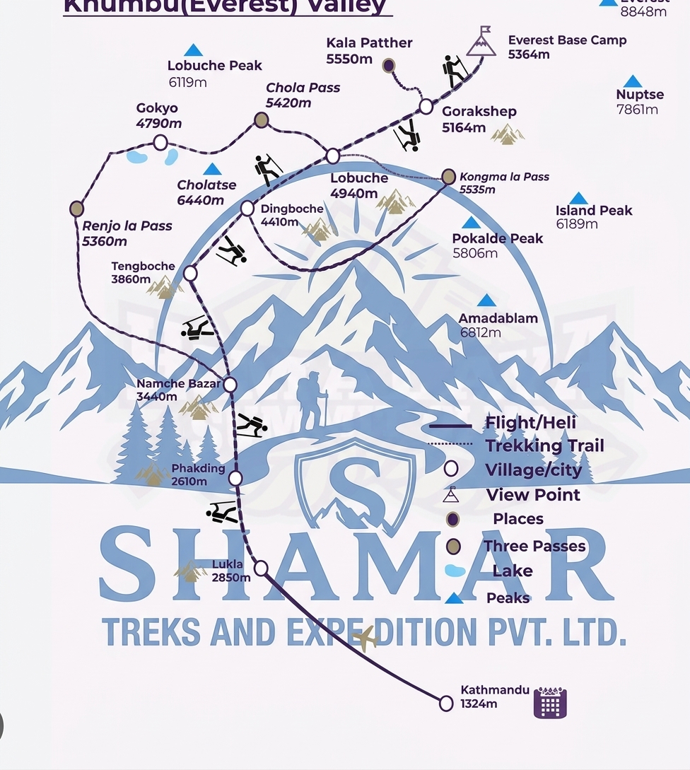
Route map image could not be loaded
Showing route for Everest Base Camp Trek
Route Information
Total Distance:130.5 km
Starting Point:Lukla
Ending Point:Lukla
Highest Point:Kala Patthar (5,545 m)
Key Locations
Lukla
Day 2
start
2,840 m
Namche Bazaar
Day 3
3,440 m
Tengboche
Day 5
3,860 m
Dingboche
Day 6
4,410 m
Lobuche
Day 8
4,940 m
Everest Base Camp
Day 9
landmark
5,364 m
Gorak Shep
Day 9
5,170 m
Kala Patthar
Day 10
viewpoint
5,545 m
Pheriche
Day 10
4,240 m
Frequently Asked Questions
No — and this surprises nearly everyone. From Base Camp itself the summit is hidden behind the Nuptse wall. Everest is visible in full from Kala Patthar at 5,545 m, which you climb before dawn the following morning. Any itinerary that includes Base Camp but not Kala Patthar has given you half the trek.
Still have questions?
Our travel experts are here to help you plan the perfect trip. Get in touch with us for personalized advice.
Reviews & Ratings
4.7
3 reviews
5★
1
4★
2
3★
0
2★
0
1★
0
James CarterVerified
26 Jun 2025
Amazing trip to Everest!
This trip exceeded all expectations. The guide was knowledgeable, and the itinerary was well-planned. Highly recommend!
William ParkerVerified
24 Jun 2025
Unforgettable Experience
The views were absolutely breathtaking...
Emma CollinsVerified
24 Jun 2025
Best Adventure of My Life
Our guide Sherpa was incredibly knowledgeable...
Share Your Experience
Have you completed this trek? Help other travelers by sharing your experience.
USD 1595
USD 1450
per person
Group Discount: 5% OFF
Quick Inquiry
Need Help?
Call Us
+977-9849052053
Email
shamartreks@gmail.com
WhatsApp
+977-9849052053
Why Choose Us?
✓ Licensed
Govt. Registered
✓ Insured
Full Coverage
✓ Expert
Local Guides
✓ Support
24/7 Help