
Everest Region (Khumbu), Nepal
Makalu Base Camp Trek
Nineteen days up the Barun valley to the foot of the world's fifth-highest mountain — three passes on the way in, no road, no shortcut, and a base camp amphitheatre that very few people ever stand in.
Package Overview
Best Time to Visit
March to May, September to November
Guided & Permitted
Licensed, insured guide and all trekking permits included
The fifth-highest mountain, and almost nobody at the bottom of it
Everest Base Camp takes tens of thousands of trekkers a year. Makalu Base Camp, beneath the fifth-highest mountain on earth and a two-day walk from Everest as the crow flies, takes a few hundred.
The difference is entirely logistical. Khumbu has an airstrip at Lukla that puts you in the mountains in forty minutes. Makalu has a flight to a Terai airstrip at Tumlingtar, a jeep to a roadhead, and then six days of walking with three passes in the way before you reach the valley you came for.
What you get in exchange is a base camp at 4,870 m where the 8,485 m south face fills an entire horizon, and where on most days your group will be the only one there. If you want that experience with lodges every night and a road never far away, Everest Base Camp is the trek to book instead — this one is for people who have already done that and want the version without the traffic.
The approach is the trek
This is the thing to understand before booking. On most base camp treks you follow one valley upwards. Here you cannot: the Barun valley is separated from the approach by a high ridge, and the route has to climb over it.
| Pass | Height | Where it sits |
|---|---|---|
| Kauma La | about 3,760 m | First of the three, above Khongma Danda |
| Shipton La | about 4,220 m | The main crossing into the Barun |
| Keke La | about 4,170 m | Immediately after, before the descent |
All three are crossed in a single long day from Khongma Danda, which is the hardest day of the approach and the one that decides how the rest of the trek feels. It is exposed, frequently snowbound in early spring, and there is no shelter between the start and the descent on the far side.
Shipton La is named for Eric Shipton, the British mountaineer and explorer who mapped much of this country in the 1950s. Walking it, you understand why the exploration took as long as it did.
How hard, and who this is for
Challenging. Nineteen days, of which fourteen are walking, mostly six to eight hours. You sleep above 3,500 m for a week and above 4,000 m for four consecutive nights. There is no technical ground and no equipment beyond boots, poles and warm clothing — but the sustained nature of it is the point.
The honest filter: if you have completed Everest Base Camp or the Annapurna Circuit and found them manageable rather than desperate, you are ready for this. If you have not done a long high trek before, this is the wrong one to start with, and we would rather say so now than at Khongma Danda.
Accommodation, and where it stops being lodges
Basic teahouses exist as far as Tashigaon. Above that the settlements are seasonal herders' huts and the accommodation ranges from very simple lodges to tents, depending on the season and what is open.
We carry camping capability from Khongma Danda upwards. In peak season parts of the upper valley have functioning simple lodges; outside it, they close. Rather than promise you a bed that may not exist at 4,800 m, we bring the alternative and use the lodge when there is one.
Food above Tashigaon is dal bhat, noodles, potatoes and eggs, and increasingly what our own kitchen cooks. Nothing up here is carried by road, so everything is carried by someone.
The Barun valley is the other reason to come
Makalu Barun National Park protects a valley that has never been logged or grazed at the intensity of most Nepali hill country, and the forest on the approach is genuinely exceptional — old growth oak, fir and rhododendron, hung with moss and lichen, with an understorey most trekkers in Nepal never see because it has long since been cleared elsewhere.
Red panda are present in these forests. So are Himalayan black bear and, at higher elevations, snow leopard, though seeing either is a matter of luck rather than planning. The birdlife through the middle elevations is among the best in the country.
It rains here more than in Khumbu, and that is precisely why the forest looks like this. Expect wet days on the approach even in a good season.
What you actually see from base camp
The base camp sits at 4,870 m on moraine at the head of the Barun glacier. Makalu's south face rises directly in front of it — a single unbroken wall of rock and ice that is difficult to take in, because there is no intervening ridge to give it scale.
From the slopes above camp, on a clear morning, Everest and Lhotse appear over the ridge to the west. Standing in one place with the fifth and first highest mountains in the world both in view is not something many treks offer, and it is the single image people come back with.
We schedule two nights at base camp for exactly this reason. One night means one chance at the weather.
Permits
- Makalu Barun National Park entry permit
- TIMS — Trekkers' Information Management System card
- A rural municipality entry permit, checked at Chichila on the way in
This is not a restricted area, so there is no agency-only permit and no minimum party size imposed by government. We set a two-person minimum ourselves because the trip requires a crew and the economics do not work otherwise.
The flight to Tumlingtar, and planning around it
Domestic flights in Nepal are weather-dependent and Tumlingtar is no exception. A cancellation costs a day, and on a nineteen-day itinerary with a fixed international flight at the end, days matter.
We build a spare day into the return in Kathmandu. We also strongly advise not booking your international departure for the morning after you are due back. If the Tumlingtar flight goes wrong on the way out, the alternative is a very long drive, and that is a better problem to have if there is slack in the schedule.
Season
Late September to November is the most reliable: clearer skies, the passes open, and the upper valley lodges running. March to May is beautiful in the forest, with rhododendron through the middle elevations, but the three passes frequently hold snow into April and the crossing day can become serious.
We do not run this trek in winter — the passes close — or in the monsoon, when the Barun approach is leech-ridden, landslide-prone and entirely cloud-bound.
Where this trek goes
- Kathmandu Valley — Seven UNESCO Monument Zones within an hour of each other
Related activities: Trekking in Nepal, Photography Tours in Nepal.
Or compare every trip we run: all trekking and tour packages.
Trip Highlights
Makalu (8,485 m), the fifth-highest mountain on earth, from its base camp
Makalu Base Camp at 4,870 m in a glacial amphitheatre
Three passes on the approach — Kauma La, Shipton La and Keke La
The Barun valley, among the least disturbed old-growth forest in the Himalaya
Everest and Lhotse from the ridge above base camp
A trek with no road access at either end of the walking
Live Weather
Detailed Itinerary
1
Day 1: Kathmandu to Tumlingtar (410 m), drive to Chichila (1,980 m)
A morning flight east to the Tumlingtar airstrip in the Arun valley, then three to four hours by jeep climbing into the hills to Chichila. The rural municipality permit is checked here. A gentle first day that covers a great deal of ground and drops you straight into hill country.
2
Day 2: Chichila to Num (1,560 m)
Three to four hours by jeep on rough road along a ridge with the Arun gorge dropping away on both sides, and first distant views of Makalu and Chamlang in clear weather. Num is a ridge-top village and the end of the road — everything beyond here is carried on someone's back.
3
Day 3: Num to Seduwa (1,500 m)
Five to six hours and a deceptive day: a steep descent of around 800 m to the Arun river, a suspension bridge crossing, and then the whole of it climbed straight back up the other side to Seduwa. The net height change is almost nothing and the legs will not agree. National park permit checked here.
4
Day 4: Seduwa to Tashigaon (2,100 m)
Five to six hours climbing steadily through farmland, small settlements and increasingly good forest. Tashigaon is the last permanent village on the route — beyond it there are only seasonal herders' settlements. It is the last place to buy anything, and the last hot shower for well over a week.
5
Day 5: Tashigaon to Khongma Danda (3,500 m)
A brutal day of six to seven hours with around 1,400 m of climbing, most of it steep and much of it on stone steps through dense old-growth forest. This is the hardest ascent of the trek and it is unrelenting. Khongma Danda is a small cluster of huts on a ridge with the first big mountain views. Camp or basic lodge.
6
Day 6: Khongma Danda to Dobato (3,600 m) over three passes
The crux of the approach: Kauma La at about 3,760 m, Shipton La at about 4,220 m and Keke La at about 4,170 m, crossed in a single seven to eight hour day with no shelter between them. Exposed, often snowbound in spring, and spectacular — the Barun valley finally opens below you from the last pass. A long descent to Dobato.
7
Day 7: Dobato to Yangle Kharka (3,600 m)
Five to six hours dropping into the Barun valley proper and then following it upstream through the finest forest on the trek — old growth fir and rhododendron, moss, waterfalls off the valley walls. Red panda live in this country though you are very unlikely to see one. Yangle Kharka is a herders' settlement on the valley floor.
8
Day 8: Yangle Kharka to Langmale Kharka (4,410 m)
Six to seven hours climbing steadily up the valley as the trees give out and the landscape turns to moraine, boulder and grazing. Peaks close in on both sides. It is a significant altitude gain and the day to walk deliberately slowly — Langmale is the last stop before base camp and the first night properly high.
9
Day 9: Langmale Kharka to Makalu Base Camp (4,870 m)
Four to five hours over moraine and glacier-side trail to the base camp at the head of the Barun glacier, where the 8,485 m south face of Makalu rises directly in front of you with nothing in between to give it scale. A short day by design, because arriving early at 4,870 m and resting is worth more than distance.
10
Day 10: Makalu Base Camp — exploration and second night
The reason there are two nights here. We walk up onto the slopes above camp, where on a clear morning Everest and Lhotse appear over the western ridge — the first and fifth highest mountains on earth in a single view. Four to five hours of walking, no pack, and a second chance at the weather if the first morning is grey.
11
Day 11: Makalu Base Camp to Yangle Kharka
Six to seven hours retracing the valley downhill, losing over 1,200 m. Easy underfoot and a genuine relief to the lungs, with the whole Barun ahead of you and the light running the other way down the valley walls.
12
Day 12: Yangle Kharka to Dobato (3,600 m)
Five to six hours back down and out of the valley floor, climbing again at the end towards the pass country. The forest section is even better in this direction because you are walking into it rather than out of it.
13
Day 13: Dobato to Khongma Danda (3,500 m) over the three passes
Seven to eight hours recrossing Keke La, Shipton La and Kauma La. It is a hard day in either direction and the weather decides how hard — we start early to be over the high ground before afternoon cloud builds. The last big mountain views of the trek are from the top of Shipton La.
14
Day 14: Khongma Danda to Tashigaon (2,100 m)
Four to five hours descending the 1,400 m you climbed on day five, on the same steep forest steps. Hard on the knees and much faster than the ascent. Tashigaon means a village, a shop, and a shower — after nine days above it, all three feel significant.
15
Day 15: Tashigaon to Seduwa (1,500 m)
Four to five hours on a gentle descent through farmland with the Arun valley opening below. Warm, green and sociable walking after the high country, through villages that see very few foreigners despite being on the main route in.
16
Day 16: Seduwa to Num (1,560 m)
Five to six hours: the day three crossing in reverse — a long drop to the Arun, the suspension bridge, and the full climb back to Num on the far side. The last walking day of the trek and, unfairly, one of the harder ones.
17
Day 17: Num to Tumlingtar (410 m)
Six to seven hours by jeep back down the ridge and out of the hills to the Arun valley floor. Rough for the first half. Overnight in Tumlingtar near the airstrip, with the first proper meal and cold drink in two and a half weeks.
18
Day 18: Tumlingtar to Kathmandu
A short morning flight west to Kathmandu, weather permitting, with the eastern Himalaya strung along the northern horizon if the sky is clear — Kanchenjunga, Makalu, Everest and Lhotse in sequence, which is a fair way to end a trek spent underneath one of them. Transfer to your hotel, and the rest of the day free. Most people spend it asleep, then eating.
19
Day 19: Kathmandu — spare day
Held against a cancelled Tumlingtar flight, which is common enough that building the buffer is standard practice rather than caution. If everything ran to schedule this is a free day in the city. We would also strongly advise not booking your international departure for the morning after this day.
Cost Details
What's Included
- Return flights, Kathmandu to Tumlingtar
- All jeep transfers, Tumlingtar to Num and return
- Makalu Barun National Park permit, rural municipality permit and TIMS card
- All accommodation on trek — lodges where they exist, tents where they do not
- Camping crew, cook and kitchen equipment for the upper valley
- Breakfast, lunch and dinner throughout the trek
- Two nights at Makalu Base Camp, for a second chance at the weather
- Licensed, insured English-speaking guide experienced on the Shipton La crossing
- Crew wages, insurance, equipment, food and accommodation
- Comprehensive first aid kit and pulse oximeter carried by the guide
- One spare night in Kathmandu against flight delays
- Government taxes and company service charge
What's Not Included
- International flights and Nepal visa
- Travel insurance — must cover helicopter evacuation to 5,000 m
- Accommodation and meals in Kathmandu beyond the spare night
- Porter — strongly recommended on a nineteen-day trek, available at a daily rate
- Hot showers, charging and bottled drinks where they exist
- Personal trekking equipment, sleeping bag rated to -20°C and insulated mat
- Tips for guide, cook and porters
- Any cost arising from flight cancellation, early descent or evacuation
Essential Information
- Maximum altitude: 4,870 m
- Trip duration: 19 days
- Difficulty: challenging
- Best season: March to May, September to November
- Group size: 2 to 10 trekkers
- Permits: Makalu Barun National Park entry permit; Rural municipality entry permit; TIMS card — all included and arranged by us
- Accommodation: Lodges to Tashigaon, then lodges or tents in the upper valley
- Guide: licensed and insured, English speaking
- Weather reference point: Makalu Base Camp
Important Cost Information
Payment Terms:
- • 25% deposit required to confirm booking
- • Balance payment due 30 days before departure
- • Full refund if cancelled 45+ days before
Fixed Departure Dates
Choose from our scheduled group departures with guaranteed departures.
Route Map
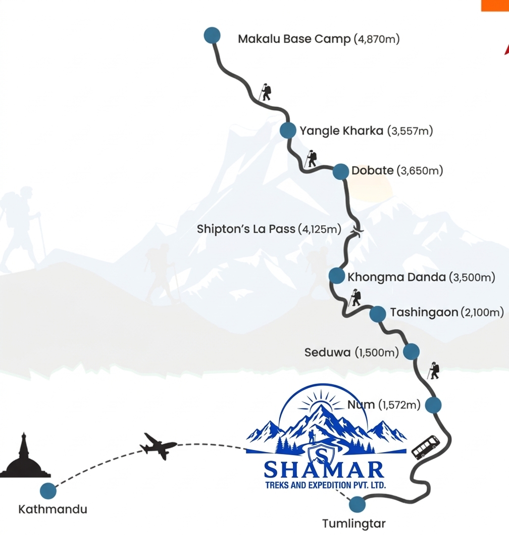
Route map image could not be loaded
Showing route for Makalu Base Camp Trek
Route Information
Starting Point:Num
Ending Point:Num
Highest Point:Makalu Base Camp (4,870 m)
Key Locations
Num
Day 2
start
1,560 m
Seduwa
Day 3
1,500 m
Tashigaon
Day 4
2,100 m
Khongma Danda
Day 5
3,500 m
Shipton La
Day 6
landmark
4,220 m
Yangle Kharka
Day 7
3,600 m
Langmale Kharka
Day 8
4,410 m
Makalu Base Camp
Day 9
viewpoint
4,870 m
Frequently Asked Questions
Makalu Base Camp is 4,870 m, at the head of the Barun glacier. Makalu itself is 8,485 m and is the fifth-highest mountain in the world. The highest point you cross on the approach is Shipton La at about 4,220 m.
Still have questions?
Our travel experts are here to help you plan the perfect trip. Get in touch with us for personalized advice.
Reviews & Ratings
—
0 reviews
5★
0
4★
0
3★
0
2★
0
1★
0
Share Your Experience
Have you completed this trek? Help other travelers by sharing your experience.