
Everest Region (Khumbu), Nepal
Gokyo Lakes Trek
Twelve days up the Dudh Koshi to the Gokyo lakes at 4,790 m, beside the longest glacier in Nepal, and up Gokyo Ri at 5,357 m for a panorama holding four of the world’s fourteen 8,000 m peaks.
Package Overview
Best Time to Visit
March to May, October to November
Guided & Permitted
Licensed, insured guide and all trekking permits included
A better view of Everest than Everest Base Camp gives you
This is the thing to settle first, because it decides which of the two treks you should book. You cannot see Everest from Everest Base Camp. The Nuptse ridge stands in the way. What you see at Base Camp is the Khumbu Icefall, which is magnificent, and a wall of rock where the mountain ought to be.
From the summit of Gokyo Ri at 5,357 m, you see Everest whole — and not only Everest. Four of the world's fourteen 8,000 m peaks stand in the same panorama:
| Peak | Altitude | Rank |
|---|---|---|
| Everest | 8,849 m | 1st |
| Lhotse | 8,516 m | 4th |
| Makalu | 8,485 m | 5th |
| Cho Oyu | 8,188 m | 6th |
Kala Patthar, the viewpoint on the Base Camp trek, does show you Everest properly. It does not show you that set. No other walkable summit in Nepal does.
And what you give up for it
You do not stand at Everest Base Camp. If the point of the trip is to have been there — and for a lot of people it legitimately is — then take the Base Camp trek and do not let anyone talk you out of it on the grounds of scenery.
What Gokyo gives in exchange is a quieter valley, a lake system nothing else in Nepal resembles, and the better photograph. The two trails run roughly parallel up neighbouring valleys and carry very different volumes of people.
| Gokyo Lakes | Everest Base Camp | |
|---|---|---|
| Days | 12 | 14 |
| Highest point | 5,357 m (Gokyo Ri) | 5,545 m (Kala Patthar) |
| See Everest from the top | Yes, with three more 8,000ers | Yes, from Kala Patthar |
| Stand at Base Camp | No | Yes |
| Foot traffic | Noticeably lower | High in season |
| Defining feature | Lakes and glacier | The Icefall |
The lakes, and why they are protected
There are six main lakes in the Gokyo system, strung up the valley on the western flank of the Ngozumpa Glacier. The village sits on the shore of the third and largest of the lower group, Dudh Pokhari, at 4,790 m.
The system was designated a Ramsar Wetland of International Importance in 2007 and is among the highest-altitude wetland systems anywhere on earth. The colour is the thing nobody is prepared for — a flat turquoise against grey moraine and brown hillside, holding that colour even under cloud.
They are also sacred. Hindu pilgrims come to the lakes during Janai Purnima, and there is a shrine at the second lake. Do not swim in them, and ask before photographing anyone at the water.
Ngozumpa, the longest glacier in Nepal
The trail to Gokyo runs along the lateral moraine of the Ngozumpa Glacier, which drains Cho Oyu and is the longest glacier in the Nepal Himalaya at roughly 36 km.
It is not the white glacier of the imagination. Its surface is buried under rock debris, pitted with melt ponds, and it cracks and shifts audibly — at night from the lodge you hear it working. Crossing it on the way to the Fifth Lake or over to the Three Passes route is a strange hour of walking over rubble with ice underneath.
How hard is it, and is 12 days enough
Moderate to strenuous. The walking is not technical anywhere — no pass, no glacier crossing on the standard itinerary, no fixed rope — but you sleep at 4,790 m and climb to 5,357 m, and that is the difficulty.
Twelve days carries two acclimatisation days, at Namche (3,440 m) and at Gokyo itself. That is the correct number and we will not sell you a shorter version. Operators advertising Gokyo in nine or ten days are cutting one of those, and the pass this trek does not have is not what hurts people — the altitude is.
| Day | Walking | What makes it hard |
|---|---|---|
| 3 | 5–6 hrs | The climb to Namche — steep, and your first real altitude |
| 6 | 5–6 hrs | Dole to Machhermo, above the treeline all day |
| 7 | 4–5 hrs | Short but thin — the lakes appear one at a time |
| 8 | 3–4 hrs | Gokyo Ri before dawn, 570 m straight up in the cold |
| 10 | 6–7 hrs | A long descent, and the day knees complain about |
The Lukla flight, honestly
Getting to Lukla means a flight that cancels. Weather closes it regularly in both main seasons, and during peak months the flight often operates from Ramechhap rather than Kathmandu, which adds a four to five hour pre-dawn drive at the start and end.
We build the itinerary expecting this and we will tell you which airport you are flying from as soon as it is confirmed rather than on the night before. Keep at least two spare days at the end of your trip. Anyone who tells you Lukla is reliable has not run enough departures.
Permits
- Sagarmatha National Park entry permit
- Khumbu Pasang Lhamu Rural Municipality fee
Both included. TIMS is not required in Khumbu — the municipality fee replaced it here, and operators still charging you for a TIMS card on an Everest-region trek are charging you for a permit you do not need. The park permit can be issued in Kathmandu or at Monjo; the municipality fee is collected at Lukla.
When to come
Late September to November is the most settled and the clearest, and it is when the lakes hold their colour best. March to May is warmer with more haze building through the afternoon, and the lakes may still be partly frozen in March.
Winter is possible and spectacularly clear, but the lodges above Dole thin out and nights at Gokyo are severe. We do not run this in the monsoon — the views are the reason to come and in July they are not there.
Where it goes from here
Gokyo is one third of the Everest Three Passes trek, which links this valley to the Base Camp trail over the Cho La and comes back over the Renjo La. If you are fit, experienced at altitude and have three weeks, that is the better trip and this one is a component of it.
The Everest region guide sets out every route in Khumbu, from Lukla day-walks to the peaks.
Where this trek goes
Related activities: Trekking in Nepal, Photography Tours in Nepal.
Or compare every trip we run: all trekking and tour packages.
Trip Highlights
Four 8,000 m peaks in one panorama from Gokyo Ri (5,357 m)
The Gokyo lakes — a Ramsar wetland of international importance
Walking the edge of the Ngozumpa Glacier, the longest in Nepal
Dudh Pokhari at 4,790 m, turquoise against brown moraine
A quieter valley than the Base Camp trail that runs parallel to it
Cho Oyu (8,188 m) at the head of the valley the whole way up
Live Weather
Detailed Itinerary
1
Day 1: Fly to Lukla (2,840 m), trek to Phakding (2,610 m)
An early flight into Lukla — or a pre-dawn drive to Ramechhap and a flight from there in peak season — then three to four hours of easy walking down the Dudh Koshi to Phakding. A deliberately short first day: you have gained a lot of height in a thirty-minute flight and the walking is mostly downhill, which is exactly what the first afternoon should be.
2
Day 2: Phakding to Namche Bazaar (3,440 m)
Five to six hours up the valley, crossing the river repeatedly on high suspension bridges, entering Sagarmatha National Park at Monjo. The last two hours are the steep climb to Namche, and on a clear day there is a first sight of Everest from a bend in the trail partway up. Namche is a horseshoe of lodges, bakeries and gear shops built into a natural bowl.
3
Day 3: Namche — acclimatisation day
Not a rest day. We climb several hundred metres and come back down to sleep, which is what makes the rest of the trek work. Options are the Everest View Hotel at 3,880 m for the Ama Dablam panorama, or Khumjung village with its monastery and school. The Sherpa culture museum above the town is worth an hour of the afternoon.
4
Day 4: Namche to Dole (4,200 m)
Five to six hours, and the day the route leaves the Base Camp trail. Climbing to Mong La on the ridge, then descending to the Dudh Koshi before a sustained climb into the Gokyo valley. The foot traffic drops away almost immediately after the junction. Dole sits among the last of the rhododendron and birch; above here the vegetation stops.
5
Day 5: Dole to Machhermo (4,470 m)
Five to six hours on a high traverse above the valley floor, treeless and open the whole way, with Cho Oyu ahead and Kangtega and Thamserku behind. Only 270 m of net gain, taken slowly on purpose. Machhermo has a Himalayan Rescue Association aid post that runs a free altitude talk most afternoons in season — go to it, even if you think you know the material.
6
Day 6: Machhermo to Gokyo (4,790 m)
Four to five hours alongside the terminal moraine of the Ngozumpa Glacier, passing the first lake and then the second before Dudh Pokhari — the third and largest — appears with the village on its shore. The colour is the thing people stop walking for. Short in distance, slow in the air at this height.
7
Day 7: Gokyo Ri (5,357 m), then Gokyo
Up before dawn for three to four hours on the round trip, climbing around 570 m of steep zigzags above the lake in the cold and dark. The summit holds Everest, Lhotse, Makalu and Cho Oyu in one sweep, with the Ngozumpa running away below and the lakes strung out behind. Back down for a late breakfast. The afternoon is free for the Fourth Lake or simply for sitting still.
8
Day 8: Gokyo — acclimatisation and the Fifth Lake
A second night at 4,790 m, which is the point of the day. Those who want it walk north to the Fifth Lake, Ngozumpa Tsho, for the view of Everest’s western flank from Scoundrel’s Viewpoint — five to six hours there and back, and the quietest ground on the trek. Those who do not stay at the lake and do nothing, which is a legitimate use of the day.
9
Day 9: Gokyo to Dole (4,200 m)
Five to six hours retracing the traverse past Machhermo, losing almost 600 m. Descending in Khumbu is a physical relief that arrives within the hour — the air thickens, appetite comes back, and people who have been quiet for two days start talking again. The valley looks entirely different walked downhill.
10
Day 10: Dole to Namche Bazaar (3,440 m)
Six to seven hours back over Mong La and down to Namche, the longest descent of the trek at around 760 m net with a stiff climb in the middle of it. This is the day for poles. Namche after a week above the treeline feels like a city, and the bakeries are not a joke.
11
Day 11: Namche to Lukla (2,840 m)
Six to seven hours back down the Dudh Koshi to Lukla, retracing the first two days in one. A long day but a steadily easier one as the air thickens. The last hour climbs again into Lukla, which nobody enjoys and everybody survives. Last night on the trail.
12
Day 12: Fly Lukla to Kathmandu
A morning flight out, weather permitting — the operative phrase for the whole trek. Flights go early because the wind rises through the day. If Lukla is closed we hold, and we will discuss a helicopter transfer with you at cost rather than leaving you to arrange it. This is why the spare days at the end of your trip matter.
Cost Details
What's Included
- Kathmandu–Lukla–Kathmandu flights, including Ramechhap transfers if required
- All lodge accommodation on trek, twin share
- Breakfast, lunch and dinner throughout the trek
- Sagarmatha National Park entry permit and Khumbu Pasang Lhamu Rural Municipality fee
- Licensed, insured English-speaking guide experienced in the Gokyo valley
- Guide wages, insurance, equipment, food and accommodation
- First aid kit and pulse oximeter carried by the guide
- Government taxes and company service charge
What's Not Included
- International flights and Nepal visa
- Travel insurance — must cover helicopter evacuation above 5,000 m
- Accommodation and meals in Kathmandu
- Porter — available on request at a daily rate
- Hot showers, wifi, charging and bottled drinks in lodges
- Personal trekking equipment and a sleeping bag rated to -15°C
- Tips for guide and porter
- Helicopter transfer if Lukla closes, and any cost arising from early descent or evacuation
Essential Information
- Maximum altitude: 5,357 m
- Trip duration: 12 days
- Difficulty: challenging
- Best season: March to May, October to November
- Group size: 1 to 12 trekkers
- Permits: Sagarmatha National Park entry permit; Khumbu Pasang Lhamu Rural Municipality fee — all included and arranged by us
- Accommodation: Lodges throughout, twin share
- Guide: licensed and insured, English speaking
- Weather reference point: Gokyo
Important Cost Information
Payment Terms:
- • 25% deposit required to confirm booking
- • Balance payment due 30 days before departure
- • Full refund if cancelled 45+ days before
Fixed Departure Dates
Choose from our scheduled group departures with guaranteed departures.
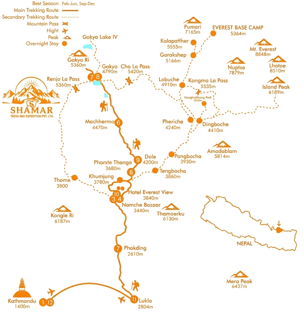
Route Map
Route map image could not be loaded
Showing route for Gokyo Lakes Trek
Route Information
Starting Point:Lukla
Ending Point:Lukla
Highest Point:Gokyo Ri (5,357 m)
Key Locations
Lukla
Day 1
start
2,840 m
Phakding
Day 1
2,610 m
Namche Bazaar
Day 2
3,440 m
Dole
Day 4
4,200 m
Machhermo
Day 5
4,470 m
Gokyo
Day 6
4,790 m
Gokyo Ri
Day 7
landmark
5,357 m
Lukla
Day 11
end
2,840 m
Frequently Asked Questions
Yes, and better than from Everest Base Camp, where Everest is hidden behind the Nuptse ridge and cannot be seen at all. From the summit of Gokyo Ri at 5,357 m you see Everest whole, together with Lhotse at 8,516 m, Makalu at 8,485 m and Cho Oyu at 8,188 m — four of the world’s fourteen 8,000 m peaks in one panorama.
Still have questions?
Our travel experts are here to help you plan the perfect trip. Get in touch with us for personalized advice.
Reviews & Ratings
—
0 reviews
5★
0
4★
0
3★
0
2★
0
1★
0
Share Your Experience
Have you completed this trek? Help other travelers by sharing your experience.