
Everest Region (Khumbu), Nepal
Everest Three Passes Trek
Nineteen days over the Kongma La, Cho La and Renjo La, taking in Everest Base Camp, Kala Patthar and the Gokyo lakes — the hardest trek in Nepal that still sleeps in lodges every night.
Package Overview
Best Time to Visit
April to May, October to early November
Guided & Permitted
Licensed, insured guide and all trekking permits included
The hardest teahouse trek in Nepal
That is not marketing. Three passes above 5,300 m, nineteen days, nine nights above 4,500 m, and a short glaciated section that occasionally needs crampons. It is still a lodge trek — you sleep indoors and eat cooked food every night — but within that category nothing else in Nepal asks this much.
The circuit links the two valleys most people choose between. You walk to Everest Base Camp, climb Kala Patthar, cross into the Gokyo valley over the Cho La, climb Gokyo Ri, and come out over the Renjo La into the Bhote Koshi. Almost nothing is walked twice.
| Pass | Altitude | Crossed on | The difficulty |
|---|---|---|---|
| Kongma La | 5,535 m | Day 9 | Longest day, least walked, boulder fields |
| Cho La | 5,420 m | Day 13 | A glacier crossing — the technical crux |
| Renjo La | 5,360 m | Day 16 | Steepest descent, best view |
The Cho La is the part to understand before you book
Most pages call this trek "challenging" and leave it at that. Here is the specific thing.
The eastern approach to the Cho La climbs a steep boulder slope, and the top section crosses a small glacier. It is short — well under an hour — and it is not mountaineering. But it is ice, it holds crevasses in places, and depending on conditions and the time of year it may need microspikes or crampons. Early in the season or after fresh snow, it may need a rope for the group.
We carry traction for everyone on this trek as standard rather than hoping it is bare that week. If conditions on the morning are poor, the pass does not get crossed and we route around it via Namche — which costs two days and is a decision the guide makes on the ground, not one made in an office to protect an itinerary.
The descent on the western side is loose rock and ice over a drop, and it is where people actually fall. Poles, and not rushing.
Kongma La is the one people underestimate
It is the highest of the three at 5,535 m, it is the least trafficked, and it comes first — before you have a fortnight of altitude behind you.
The day from Chhukung is eight to ten hours. There is no lodge, no teahouse and no shelter between the two ends of it, and the ground on the eastern side is an exhausting boulder field with cairns rather than a trail. It finishes by crossing the Khumbu Glacier to reach Lobuche. People who find the Cho La frightening generally find the Kongma La simply long, and it is the one that most often gets abandoned.
We spend two nights at Chhukung before it. That is not padding.
Renjo La, and the best view on the circuit
If the trek has a single moment, it is the top of the Renjo La at 5,360 m looking back east. Everest stands at the head of the valley with the Gokyo lakes laid out below and the Ngozumpa running between them. Gokyo Ri gives you the four-eight-thousander panorama; the Renjo La gives you the composition.
The western descent is the steepest sustained downhill on the trek — a long staircase of stone slabs that is genuinely unpleasant in snow.
Who should not book this
We would rather say this now than at Chhukung.
- If you have never been above 5,000 m, this should not be the trip where you find out how you respond. Do Base Camp or Gokyo first.
- If you have not walked for two consecutive weeks before, the issue is not any single day but day fourteen with ten more to come.
- If your schedule has no slack, a weather day on a pass, or a Lukla closure, breaks a tight return flight.
- If you need to be certain of the full route, book something else. Any of the three passes can close, and roughly one departure in five does not cross all three.
None of that is a reason for a fit, experienced walker to hesitate. It is a reason for the wrong person not to find out the hard way at 5,000 m.
Acclimatisation, which is what 19 days buys
You could compress this to fifteen days. People sell it. What gets cut is always acclimatisation, and on a route with nine nights above 4,500 m that is the one thing worth paying for.
This itinerary carries four acclimatisation nights — Namche, Dingboche, a second night at Chhukung before the Kongma La, and a second at Gokyo. Each one sits immediately before a step up, which is where they do their work.
| Night | Sleeping altitude | Why it is there |
|---|---|---|
| Namche ×2 | 3,440 m | The standard first adjustment |
| Dingboche ×2 | 4,410 m | Before the push above 4,900 m |
| Chhukung ×2 | 4,730 m | Directly before the Kongma La |
| Gokyo ×2 | 4,790 m | Before Gokyo Ri and the Renjo La |
Permits
- Sagarmatha National Park entry permit
- Khumbu Pasang Lhamu Rural Municipality fee
Both included, and that is the full list. TIMS is not required in Khumbu. None of the three passes is a restricted area and there is no additional permit for them, whatever you may be quoted elsewhere.
When to go
The window is narrower than for the valley treks, because passes close.
Mid-October to early November is the most reliable: settled weather, the passes usually clear of fresh snow, cold but manageable nights. April to mid-May is the other window, warmer with more afternoon cloud, and with the chance of lingering winter snow on the Cho La in early April.
We do not run this trek in winter — the passes hold snow and the high lodges close — and we do not run it in the monsoon.
What happens if a pass is closed
You still get a very good trek. The fallbacks are worked out in advance: skip the Kongma La and walk the valley to Lobuche; bypass the Cho La by dropping to Namche and climbing the other valley; skip the Renjo La and descend from Gokyo the way the Gokyo trek does.
Every one of those still reaches Base Camp and Gokyo. We would rather set that out now than have the conversation at 4,800 m in bad weather. The Everest region guide covers how the valleys connect.
Where this trek goes
Related activities: Trekking in Nepal, Photography Tours in Nepal.
Or compare every trip we run: all trekking and tour packages.
Trip Highlights
Three passes above 5,300 m — Kongma La, Cho La and Renjo La
Everest Base Camp (5,364 m) and Kala Patthar (5,545 m)
The Gokyo lakes and Gokyo Ri, included rather than an add-on
The Renjo La view — Everest above the lakes, the best on the circuit
Crossing the Ngozumpa Glacier on foot
A complete loop of Khumbu with almost no ground walked twice
Live Weather
Detailed Itinerary
1
Day 1: Fly to Lukla (2,840 m), trek to Phakding (2,610 m)
Flight into Lukla, or a pre-dawn drive to Ramechhap and a flight from there in peak season, then three to four hours down the Dudh Koshi. Short and downhill on purpose after a morning of altitude gained in a thirty-minute flight. Nineteen days starts gently; it does not stay that way.
2
Day 2: Phakding to Namche Bazaar (3,440 m)
Five to six hours up the valley on high suspension bridges, into Sagarmatha National Park at Monjo, then the steep climb to Namche. On a clear day Everest appears from a bend partway up. Namche is the last place with bank machines, gear shops and reliable wifi, and the last place to buy anything you have forgotten.
3
Day 3: Namche — acclimatisation day
An active day rather than a rest. Up to the Everest View Hotel at 3,880 m or across to Khumjung and back, climbing several hundred metres and returning to sleep low. We also check kit properly today, because what you are carrying matters more on this route than on any other lodge trek in Nepal.
4
Day 4: Namche to Tengboche (3,860 m)
Five to six hours, descending to the Dudh Koshi at Phunki Thenga and then climbing steadily through forest to the monastery. Tengboche Gompa is the spiritual centre of Khumbu and sits on a shelf facing Ama Dablam, Everest and Lhotse. The afternoon prayer ceremony is open to visitors and worth planning the day around.
5
Day 5: Tengboche to Dingboche (4,410 m)
Five to six hours through Pangboche, where the older gompa above the village is the oldest in Khumbu, then up into the Imja valley as the last of the trees give out. Dingboche is a village of stone-walled fields at 4,410 m. The air is noticeably different here and most people feel it on the last climb into the village.
6
Day 6: Dingboche — acclimatisation day
Up Nangkartshang Peak above the village to around 5,080 m, four to five hours there and back, then down to sleep at 4,410 m. This is the first time most people go above 5,000 m on the trek and it is a useful rehearsal — both for the body and for finding out how you actually respond before a pass depends on it.
7
Day 7: Dingboche to Chhukung (4,730 m)
Two to three hours up the Imja valley, short and deliberately easy, with Lhotse’s south face filling the view ahead and Ama Dablam behind. Chhukung is a small cluster of lodges rather than a village. The afternoon is free, and the point of the day is to arrive without effort before the hardest day of the trek.
8
Day 8: Chhukung — acclimatisation day
Chhukung Ri, around 5,550 m, for those going well — four to five hours and the best preparation available for the Kongma La, which is the same height and considerably longer. Anyone not going well stays put, and that is a legitimate choice rather than a failure. Early night: tomorrow starts in the dark.
9
Day 9: Kongma La (5,535 m) to Lobuche (4,940 m)
The hardest day of the trek. Eight to ten hours with no shelter of any kind between Chhukung and Lobuche. A long climb past the Nuptse glacier lakes onto a boulder field marked by cairns rather than a trail, then the pass itself at 5,535 m with prayer flags and a view down both sides. The descent crosses the Khumbu Glacier — loose moraine, slow going — before the last pull up to Lobuche.
10
Day 10: Lobuche to Gorak Shep (5,170 m) and Everest Base Camp (5,364 m)
Six to seven hours in total. Two to three hours along the Khumbu Glacier’s lateral moraine to Gorak Shep, then the walk out to Base Camp at 5,364 m and back. Base Camp is about the Khumbu Icefall rather than about Everest, which is not visible from here. In spring the tents of the expeditions are spread across the moraine. Back to Gorak Shep for the night.
11
Day 11: Kala Patthar (5,545 m), then Dzongla (4,830 m)
Before dawn up Kala Patthar, the highest point of the trek at 5,545 m, for Everest’s south-west face catching first light with Nuptse and Pumori alongside. Cold and steep and the best hour on this side of the circuit. Then back down and a four to five hour traverse to Dzongla, a handful of lodges on a shelf below the Cho La.
12
Day 12: Dzongla — weather and rest day
A buffer day, and the most useful day in the itinerary. If the Cho La is in condition we use it to rest, acclimatise and prepare. If it is not, we have a day in hand to wait rather than crossing a glaciated pass in poor visibility because the schedule says so. Most itineraries sold at fifteen days are missing exactly this day.
13
Day 13: Cho La (5,420 m) to Thagnak (4,700 m)
Seven to eight hours and the technical crux. An early start for the steep boulder climb to the pass, with a short glaciated section near the top where we put traction on — crevasses in places, and roped if conditions require it. The pass itself is narrow with prayer flags and a drop on the far side. The western descent is loose rock over ice and is where care matters most. Thagnak is a few lodges on the edge of the Ngozumpa.
14
Day 14: Thagnak to Gokyo (4,790 m)
Three to four hours, most of it crossing the Ngozumpa Glacier itself — an hour or more of walking over rock-covered ice, past melt ponds, with the surface cracking audibly underfoot. Strange ground, and unlike anything else on the trek. Gokyo appears on the far side on the shore of Dudh Pokhari, and after two hard days the lake is a shock of colour.
15
Day 15: Gokyo Ri (5,357 m), then Gokyo
Up before dawn for 570 m of steep zigzags above the lake, three to four hours there and back. The summit holds Everest, Lhotse, Makalu and Cho Oyu in one panorama with the lakes strung out below. Back for a late breakfast, then a second night at 4,790 m — rest before the last pass, and the free afternoon most people need by now.
16
Day 16: Renjo La (5,360 m) to Lungden (4,380 m)
Seven to eight hours. A steady three to four hour climb on the western side of the lake to the pass, and the view back east is the one people remember: Everest at the head of the valley, the Gokyo lakes below, the Ngozumpa between them. The descent is the steepest sustained downhill of the trek, a long staircase of stone slabs, before easing into the Bhote Koshi valley at Lungden.
17
Day 17: Lungden to Namche Bazaar (3,440 m)
Six to seven hours down the Bhote Koshi through Thame, whose monastery is among the oldest in Khumbu and which is the home village of a long line of Everest summiteers. The valley is quiet — few trekkers come this way — and the descent of nearly 950 m is felt mostly as relief. Namche, after sixteen days, is overwhelming in a pleasant way.
18
Day 18: Namche to Lukla (2,840 m)
Six to seven hours retracing the first two days in one, down the steep hill out of Namche, back across the suspension bridges and along the Dudh Koshi. A long day that gets easier with every hundred metres lost. The final climb into Lukla is a last unwelcome effort. Last night on the trail, and traditionally the one where the guides are bought a drink.
19
Day 19: Fly Lukla to Kathmandu
A morning flight out, weather permitting. Flights go early because wind builds through the day, and if Lukla is closed we hold and discuss a helicopter transfer at cost. After nineteen days, the thirty-minute flight back over country it took you a fortnight to cross is the strangest part of the trip.
Cost Details
What's Included
- Kathmandu–Lukla–Kathmandu flights, including Ramechhap transfers if required
- All lodge accommodation on trek, twin share
- Breakfast, lunch and dinner throughout the trek
- Sagarmatha National Park entry permit and Khumbu Pasang Lhamu Rural Municipality fee
- Microspikes or crampons for the Cho La crossing, and a rope carried by the guide
- Licensed, insured English-speaking guide experienced on all three passes
- Guide wages, insurance, equipment, food and accommodation
- First aid kit and pulse oximeter carried by the guide
- Government taxes and company service charge
What's Not Included
- International flights and Nepal visa
- Travel insurance — must cover helicopter evacuation above 5,500 m
- Accommodation and meals in Kathmandu
- Porter — strongly recommended on this route, at a daily rate
- Hot showers, wifi, charging and bottled drinks in lodges
- Personal trekking equipment and a sleeping bag rated to -20°C
- Tips for guide and porter
- Helicopter transfer if Lukla closes, and any cost arising from early descent or evacuation
Essential Information
- Maximum altitude: 5,545 m
- Trip duration: 19 days
- Difficulty: expert
- Best season: April to May, October to early November
- Group size: 1 to 10 trekkers
- Permits: Sagarmatha National Park entry permit; Khumbu Pasang Lhamu Rural Municipality fee — all included and arranged by us
- Accommodation: Lodges throughout, twin share
- Guide: licensed and insured, English speaking
- Weather reference point: Lobuche
Important Cost Information
Payment Terms:
- • 25% deposit required to confirm booking
- • Balance payment due 30 days before departure
- • Full refund if cancelled 45+ days before
Fixed Departure Dates
Choose from our scheduled group departures with guaranteed departures.
Route Map
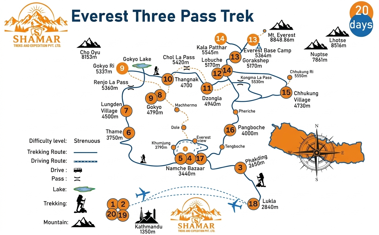
Route map image could not be loaded
Showing route for Everest Three Passes Trek
Route Information
Starting Point:Lukla
Ending Point:Lukla
Highest Point:Kala Patthar (5,545 m)
Key Locations
Lukla
Day 1
start
2,840 m
Namche Bazaar
Day 2
3,440 m
Tengboche
Day 4
3,860 m
Dingboche
Day 5
4,410 m
Chhukung
Day 7
4,730 m
Kongma La
Day 9
landmark
5,535 m
Lobuche
Day 9
4,940 m
Everest Base Camp
Day 10
landmark
5,364 m
Gorak Shep
Day 10
5,170 m
Kala Patthar
Day 11
landmark
5,545 m
Dzongla
Day 11
4,830 m
Cho La
Day 13
landmark
5,420 m
Gokyo
Day 14
4,790 m
Renjo La
Day 16
landmark
5,360 m
Lukla
Day 18
end
2,840 m
Frequently Asked Questions
It is the hardest teahouse trek in Nepal. Three passes above 5,300 m, nineteen days, nine nights above 4,500 m, and days of eight to ten hours on the pass crossings. The walking is not technical except for a short glaciated section on the Cho La, but the sustained altitude and the length are what make it hard. You should have trekked at altitude before.
Still have questions?
Our travel experts are here to help you plan the perfect trip. Get in touch with us for personalized advice.
Reviews & Ratings
—
0 reviews
5★
0
4★
0
3★
0
2★
0
1★
0
Share Your Experience
Have you completed this trek? Help other travelers by sharing your experience.