
Annapurna Region, Nepal
Mohare Danda Trek
Four days on a trail whose lodges are owned by the villages that run them, climbing to a 3,300 m ridge with Dhaulagiri directly opposite, and finishing over Poon Hill from the quiet side.
Package Overview
Best Time to Visit
March to May, September to December
Guided & Permitted
Licensed, insured guide and all trekking permits included
A trail the villages own outright
Plenty of trekking companies talk about community benefit. On the Mohare Danda trail the lodges are the community's property — built, owned and staffed by village committees in Myagdi, with the surplus going into local institutions rather than to a lodge owner in Pokhara.
The trail grew out of work by Mahabir Pun, a teacher from the village of Nangi who returned home after studying abroad and spent years building schools, a wireless network across the ridges, and eventually a set of community lodges he called the Communities Eco-Lodge Trek. He received the Ramon Magsaysay Award in 2007 for that work, largely for connecting remote Myagdi villages to the internet using improvised equipment.
What you get as a result is not a better bed. It is a different transaction: your room charge and your dinner are village revenue, and the committee decides what it funds. That is the honest version of "sustainable trekking" — unglamorous, accounted for, and visible in the school buildings you walk past.
Dhaulagiri, from the seat opposite
Mohare Danda sits on the ridge dividing the Kali Gandaki from the Modi valley, and its particular gift is Dhaulagiri I (8,167 m) directly across the gorge — not glimpsed past a shoulder, but filling the western sky from base to summit.
That is unusual. From Poon Hill, three hours further east, Dhaulagiri is impressive but further off and partly foreshortened. Here the Kali Gandaki — the deepest gorge on earth by some measures, running between Dhaulagiri and Annapurna I — does the work of clearing the foreground for you.
| Peak | Height | From Mohare Danda |
|---|---|---|
| Dhaulagiri I | 8,167 m | Due west, unobstructed, dominant |
| Annapurna I | 8,091 m | North-east |
| Annapurna South | 7,219 m | East |
| Nilgiri | 7,061 m | North, above the gorge |
| Machhapuchhre | 6,993 m | East, in profile |
| Tukuche Peak | 6,920 m | North-west, on the Dhaulagiri massif |
Why this route rather than Poon Hill
This trek ends over Poon Hill, so it is not a choice between the two so much as a question of how you get there.
| Mohare Danda route | Standard Poon Hill route | |
|---|---|---|
| Trekkers on the trail | Very few until the last day | Busy throughout |
| Highest point | 3,300 m at Mohare | 3,210 m at Poon Hill |
| Lodge ownership | Village committees | Private, mostly non-local |
| Accommodation standard | Simple; homestay on night one | Comfortable, with choice |
| Poon Hill at sunrise | Reached from the west, with the crowd | Same |
| Repeated ground | None | None |
The practical difference is the first two days. You spend them on a trail where you may not see another foreign trekker, in villages that are not organised around your arrival — and then you rejoin the main route at the end, which is when the company appears.
If you want the classic version with better lodges and no homestay, take Ghorepani Poon Hill. If you want the quiet approach and the community model, take this.
What the walking is actually like
Four days, around 40 km, and a shape that front-loads the effort.
| Day | Distance | Walking | Height change |
|---|---|---|---|
| 1 | about 8 km | 5–6 hrs after a 2 hr drive | Steady climb to 1,450 m |
| 2 | about 12 km | 6–7 hrs | +1,850 m to 3,300 m |
| 3 | about 9 km | 5–6 hrs | Over 3,210 m, down to 2,874 m |
| 4 | about 11 km | 4–5 hrs, then a drive | −1,800 m to the road |
Day two is the day. Around 1,850 m of ascent, beginning with roughly two hours of stone staircase before the trail settles into forest. It is the biggest single climb on any of our four-day treks and the reason this is graded moderate rather than easy. Nobody finds it trivial; almost everybody finishes it.
Day one is gentler than the distance suggests — a long, steadily rising path rather than a climb, which is why it works as a first walking day straight off a drive.
Lespar, and what a homestay night involves
Lespar is a Magar village at around 1,450 m and you sleep in someone's house. That is worth being specific about, because expectations cause more disappointment here than conditions do.
You get a room with a bed and blankets, an outside or shared toilet, a bucket of hot water if you want to wash, and dinner cooked on the family's stove from what the family grows — rice, lentils, seasonal greens, pickle, possibly chicken if it has been arranged. You eat when the household eats. There is no menu and no bar.
In exchange you are in a working Magar house in Myagdi with people who are hosting rather than serving. If that sounds like the good part, this trek is for you. If you would rather have a lockable door and a hot shower, say so at booking and we will route you through lodge accommodation instead where it exists.
Mohare Danda itself
The ridge-top accommodation is a community eco-lodge at 3,300 m — proper rooms, a dining room with a stove, solar power and a view from the windows that most hotels charge four figures for. It is the most comfortable high-altitude night on any of our short treks, which surprises people who assume community-run means rough.
There is a small tower on the ridge for the full panorama. Sunset is usually the better light here: Dhaulagiri faces west, so it takes the last of the sun full-on while Annapurna has already gone into shadow.
Kokhe Danda and rejoining the crowd
Day three traverses east along the ridge over Kokhe Danda and on to Poon Hill, dropping to Ghorepani for the night. It is a fine ridge walk with the whole Dhaulagiri–Annapurna arc on your left, and for most of it you will still be on your own.
Then you reach Poon Hill, and in October there will be a few hundred people on it. This is not a flaw in the itinerary; it is the reality of the most accessible sunrise viewpoint in Nepal. Having spent two days with the same mountains to yourself, most of our clients find it more funny than annoying.
If solitude matters more than ticking Poon Hill, the Muldai View Point trek reaches a higher, emptier viewpoint in the same four days.
Permits
Both included and arranged by us in Pokhara:
- ACAP — Annapurna Conservation Area Project entry permit
- TIMS — Trekkers' Information Management System card
Bring your passport and two passport photographs. Checkpoints on this route are at the ACAP post near the start and again at Ghorepani.
Season
October and November are the clearest and Dhaulagiri is at its best. March to May adds rhododendron through the forest belt on day two and warmer nights in Lespar. December works well — the ridge lodge is heated in the dining room and the air is exceptionally clear — but expect hard frost at 3,300 m.
We do not run this in the monsoon. The day-two staircase is dangerous when wet, the views are the whole point, and the lower forest has leeches.
Where this trek goes
- Pokhara — A lakeside town at 820 m with the Annapurnas 30 km away
Related activities: Trekking in Nepal.
Or compare every trip we run: all trekking and tour packages.
Trip Highlights
Mohare Danda (3,300 m) with Dhaulagiri I straight across the valley
Lodges owned and run by the villages, with profits funding local schools
Lespar — a Magar homestay village, and the reason this route feels different
Finishes over Kokhe Danda and Poon Hill (3,210 m) from the empty side
Two 8,000 m peaks visible from the ridge: Dhaulagiri I and Annapurna I
Four days from Pokhara, no flight, no repeated ground
Live Weather
Detailed Itinerary
1
Day 1: Pokhara to Patichaur, trek to Lespar (1,450 m)
Around two hours west on the Baglung highway to Patichaur, then five to six hours of walking — roughly 8 km on a path that rises steadily rather than climbing hard, through farmland and small Magar settlements. It is an easy introduction and deliberately so, given you started the day in a vehicle. Homestay in Lespar: a family house, a shared meal cooked on the household stove, and no other trekkers in the village.
2
Day 2: Lespar to Mohare Danda (3,300 m)
The hard day — around 12 km and 1,850 m of ascent over six to seven hours. It opens with roughly two hours of stone staircase, then eases into oak and rhododendron forest before breaking out onto the ridge. Take it slowly; there is no prize for arriving early. The reward is the community eco-lodge on the ridge, a genuine room with a stove in the dining hall, and Dhaulagiri I filling the western sky. Sunset is the better light here.
3
Day 3: Mohare Danda to Ghorepani (2,874 m) via Kokhe Danda and Poon Hill (3,210 m)
Five to six hours and about 9 km of ridge walking east over Kokhe Danda, with the Dhaulagiri and Annapurna massifs on your left the whole way and almost nobody else on the trail. The route joins the main path shortly before Poon Hill, where you will meet the crowds for the first time in three days, then drops a short way into Ghorepani for the night — a proper trekking village with hot showers and a choice of dinner.
4
Day 4: Ghorepani to Pokhara
Optionally back up to Poon Hill for sunrise, which takes an hour each way, then the descent — four to five hours and around 1,800 m down through Ulleri and its long stone staircase to the road at Hile or Tikhedhunga. A drive of around two hours brings you into Pokhara in the afternoon.
Cost Details
What's Included
- Private vehicle, Pokhara to Patichaur and return from Hile or Tikhedhunga
- One night homestay in Lespar, two nights in community lodges
- Breakfast, lunch and dinner throughout the trek
- Rooms booked in advance at the Mohare Danda community lodge
- Licensed, insured English-speaking trekking guide
- ACAP entry permit and TIMS card
- Guide wages, insurance, food and accommodation
- First aid kit carried by the guide
- Government taxes and company service charge
What's Not Included
- International flights and Nepal visa
- Travel insurance — must cover helicopter evacuation
- Accommodation and meals in Pokhara
- Porter — available on request, hired through the village committees
- Hot showers, wifi, charging and bottled drinks
- Personal trekking equipment, sleeping bag and poles
- Tips for guide and porter
- Any cost arising from early descent or trip changes
Essential Information
- Maximum altitude: 3,300 m
- Trip duration: 4 days
- Difficulty: moderate
- Best season: March to May, September to December
- Group size: 1 to 12 trekkers
- Permits: ACAP entry permit; TIMS card — all included and arranged by us
- Accommodation: Community eco-lodges and one village homestay
- Guide: licensed and insured, English speaking
- Weather reference point: Ghorepani
Important Cost Information
Payment Terms:
- • 25% deposit required to confirm booking
- • Balance payment due 30 days before departure
- • Full refund if cancelled 45+ days before
Fixed Departure Dates
Choose from our scheduled group departures with guaranteed departures.
Route Map
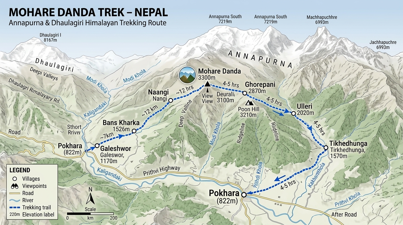
Route map image could not be loaded
Showing route for Mohare Danda Trek
Route Information
Starting Point:Patichaur
Ending Point:Ghorepani
Highest Point:Mohare Danda (3,300 m)
Key Locations
Patichaur
Day 1
start
1,100 m
Lespar
Day 1
1,450 m
Mohare Danda
Day 2
3,300 m
Poon Hill
Day 3
viewpoint
3,210 m
Ghorepani
Day 3
end
2,874 m
Frequently Asked Questions
Mohare Danda is 3,300 m, the highest point of the trek and slightly higher than Poon Hill at 3,210 m, which you cross on day three. You sleep at the community eco-lodge on the Mohare ridge.
Still have questions?
Our travel experts are here to help you plan the perfect trip. Get in touch with us for personalized advice.
Reviews & Ratings
—
0 reviews
5★
0
4★
0
3★
0
2★
0
1★
0
Share Your Experience
Have you completed this trek? Help other travelers by sharing your experience.