
Everest Region (Khumbu), Nepal
Island Peak with Everest Base Camp
Fifteen days combining the walk to Everest Base Camp with the ascent of Island Peak at 6,189 m — the most accessible first 6,000 m summit in Nepal, and considerably more technical than the phrase "trekking peak" suggests.
Package Overview
Best Time to Visit
April to May, October to November
Guided & Permitted
Licensed, insured guide and all trekking permits included
"Trekking peak" is a permit category, not a difficulty rating
Island Peak is classified by the Nepal Mountaineering Association as a trekking peak. That phrase has probably caused more disappointment on this mountain than any other single thing, because it describes how the permit is administered and nothing whatever about what the climb involves.
Here is what it actually involves: a roped glacier crossing with crevasses, a steep headwall of snow and ice climbed on fixed rope with a jumar, and an exposed summit ridge. You will wear a harness, a helmet and crampons, you will be roped to a guide, and you will use an ice axe.
It is the most accessible 6,000 m summit in Nepal and a superb first one. It is not a walk.
What you actually need to be able to do
No previous mountaineering experience is required, which is true and regularly misunderstood. What is required is this.
| Requirement | Why |
|---|---|
| Comfortable walking 6–8 hrs on consecutive days | The approach is a full Everest Base Camp trek |
| Steady in exposed places | The summit ridge has serious drops on both sides |
| Willing to be taught rope skills in a day | We run a dedicated skills session at base camp |
| Able to start walking at 1 or 2 am | Summit day is 10–14 hours from high camp |
| Prepared to turn around | The guide's decision is final and not refundable against |
The skills day at base camp is where you learn to use a jumar, walk in crampons, and move roped on a glacier. It is not a formality and we will not take a client onto the headwall who has not done it.
Why the Base Camp trek comes first
You could reach Island Peak in far fewer days by going straight up the Imja valley. Almost nobody who does that summits.
The itinerary walks to Everest Base Camp (5,364 m) and climbs Kala Patthar (5,545 m) before turning into the Imja valley, which means that by the time you reach Island Peak Base Camp at 5,087 m you have already been above 5,500 m and slept at over 5,000 m repeatedly. That is not sightseeing bolted onto a climb — it is the acclimatisation programme, and it is the single biggest factor in whether you stand on top.
It also means that if the summit does not happen, you have still done one of the great treks in the world rather than nothing.
Summit day, hour by hour
From high camp at around 5,600 m, and it is long.
- 1–2 am: away by headtorch on rock and scree, gaining height steadily in the dark.
- Around dawn: the glacier. Crampons on, rope on, and a crossing that may involve stepping over crevasses or a ladder, depending on the year.
- Mid-morning: the headwall — roughly 100 to 150 m of steep snow and ice on fixed rope, climbed with a jumar. This is the part people find hardest and it is entirely about pacing.
- The ridge: narrow, corniced, exposed, and short. Then the summit at 6,189 m, with Lhotse filling the sky directly north.
- Afternoon: all the way back down to base camp. The descent is where accidents happen, which is why we do not linger on top.
On summit success rates
We will not publish one. Any operator quoting you a percentage for Island Peak is quoting a number nobody can verify, drawn from a sample they chose, and the honest position is that it depends on three things: the weather window, how you acclimatised, and whether the fixed rope on the headwall is in good condition on the day.
What we will commit to is this. One guide per climber on summit day. A full acclimatisation programme rather than a compressed one. And a guide who will turn you around when they should, with the company's backing, because a client who is talked into continuing is the failure mode that actually kills people on this mountain.
Island Peak, Lobuche or Mera — choosing between them
| Island Peak | Lobuche East | Mera Peak | |
|---|---|---|---|
| Height | 6,189 m | 6,119 m | 6,476 m |
| Days with EBC | 15 | 15 | 18 |
| Summit day difficulty | Headwall and exposed ridge | Steeper, more sustained | Technically the easiest |
| Hardest element | The headwall | The climb itself | Amphu Laptsa, not the peak |
| Best for | A first 6,000 m peak | A short trip with real climbing | Height, and remoteness |
If you want the highest summit, Mera Peak is higher and its summit slope is easier — but reaching Everest Base Camp from it requires a technical pass. If you have less time, Lobuche East climbs directly off the Base Camp trail.
Permits, and why there are four
- NMA climbing permit for Island Peak — the fee is seasonal, higher in spring and autumn
- Sagarmatha National Park entry permit
- Khumbu Pasang Lhamu rural municipality fee, collected locally at Lukla
- TIMS card
All four are included. Solo climbing is not permitted on Island Peak: the NMA permit requires a certified climbing guide, which is why there is no version of this trip without one.
Equipment — what we provide and what you bring
We provide the group climbing hardware: ropes, ice screws, snow bars and the fixed line, plus a harness, helmet, jumar, carabiners and ice axe if you need them. Say so at booking and they will be waiting for you.
You bring, or rent in Kathmandu: mountaineering boots stiff enough to take a crampon, a down jacket rated for 6,000 m, a sleeping bag to -20°C, and proper gloves. Boots are the one item not to rent if you can avoid it — cold feet on the headwall end more summit attempts than anything except weather.
Season
April to May and October to November, and within those the middle weeks. Spring generally has more settled snow on the headwall; autumn has clearer air and colder nights. Outside these windows the mountain is not a reasonable objective and we do not run it.
Where this trek goes
- Kathmandu Valley — Seven UNESCO Monument Zones within an hour of each other
Related activities: Peak Climbing in Nepal, Trekking in Nepal.
Or compare every trip we run: all trekking and tour packages.
Trip Highlights
Island Peak (Imja Tse) at 6,189 m — a genuine glaciated summit
Everest Base Camp (5,364 m) and Kala Patthar (5,545 m) beforehand
A dedicated skills day at base camp before the climb
Ama Dablam, Lhotse and Nuptse at close range from the Imja valley
Acclimatisation built by the Base Camp trek rather than rushed
One climber to one guide on summit day
Live Weather
Detailed Itinerary
1
Day 1: Fly to Lukla (2,840 m), trek to Phakding (2,610 m)
The flight in is thirty minutes and lifts you from 1,400 m to 2,840 m, so the first afternoon deliberately loses height again: three to four hours downhill beside the Dudh Koshi. In peak season the flight leaves from Ramechhap instead of Kathmandu, which means a drive before dawn. Harnesses, boots and crampons get checked over dinner — this version has no Kathmandu day, so anything missing has to be solved in Namche.
2
Day 2: Phakding to Namche Bazaar (3,440 m)
Five to six hours, ending with the hill everyone remembers: a relentless 600 m zigzag from the Hillary bridge up to the town. Everest shows briefly through a gap on the way if the cloud is kind. Namche is the last gear shop in the valley and the last bank machine, and a climbing party that needs a spare carabiner or a warmer glove buys it here or does without.
3
Day 3: Namche Bazaar — acclimatisation day
Untouched by the shortening, and the first of the two days this climb genuinely rests on. We walk up several hundred metres — Khumjung, or the viewpoint above the airstrip — and come back to sleep at Namche. Your guide starts taking oxygen saturation readings today, so there is a baseline to compare against when it matters at 5,000 m.
4
Day 4: Namche to Tengboche (3,860 m)
Five to six hours with a sting: a long contour, a drop of 300 m to the river at Phunki Thenga, then the climb back up through forest to the monastery. Tengboche faces Ama Dablam square on, and Ama Dablam is the mountain most people photograph thinking it is Everest. Cold evening on this shelf — the first night you want the down jacket out of the bag.
5
Day 5: Tengboche to Dingboche (4,410 m)
Five to six hours. Through Pangboche, where the old gompa sits above the village, then out of the trees for good into the open Imja valley. You will notice the change in your own breathing somewhere around Shomare. Dingboche is a scatter of stone-walled potato fields, and the walk in feels longer than the distance warrants.
6
Day 6: Dingboche — acclimatisation day
The second untouched day. Up the ridge of Nangkartshang to roughly 5,080 m and straight back down to sleep at 4,410 m — four to five hours of work for no distance gained, which is exactly the point. For most climbers this is the first time above 5,000 m, and how you move on it tells your guide more than any questionnaire.
7
Day 7: Dingboche to Lobuche (4,940 m)
Five to six hours, flat for the first half and then up the moraine wall at Thukla to the memorial ridge, where the cairns stand for people who did not come back from Everest — a disproportionate number of them Sherpas. Worth walking slowly through. Lobuche beyond it is cold, basic and perched on glacial rubble.
8
Day 8: Lobuche to Everest Base Camp (5,364 m), night at Gorak Shep (5,170 m)
Six to seven hours all told, and the slowest ground yet: broken moraine beside the Khumbu Glacier to Gorak Shep, drop the packs, then out and back to Base Camp. Everest is not visible from Base Camp — Nuptse blocks it — and what you have come to see is the Icefall, which is enough. Sleeping at 5,170 m is harder than reaching it.
9
Day 9: Kala Patthar (5,545 m), descend to Dingboche (4,410 m)
Dark start for the 375 m grind up Kala Patthar, where Everest finally stands clear with Pumori behind you. This is the highest you go on foot before the mountain, and it is the whole reason Base Camp comes first in this itinerary rather than after. Then more than 1,100 m of descent to Dingboche, which is medicine: you sleep low tonight and climb better for it.
10
Day 10: Dingboche to Chhukung (4,730 m)
Two to three hours up the Imja valley, short and easy on purpose, with the south face of Lhotse filling the view ahead and Ama Dablam behind. The afternoon is rest, and the guide goes through the technical kit with you so nothing is unfamiliar tomorrow.
11
Day 11: Chhukung to Island Peak Base Camp (5,087 m), skills afternoon
Three to four hours up the valley to the base camp on open ground below the moraine. The afternoon is the climbing skills session: crampons, harness, jumar and figure-of-eight, fixed-rope technique and a ladder crossing. On the nineteen-day version this had a full day to itself. Here it is an afternoon — enough if you arrive having practised at home, and not enough if you have not.
12
Day 12: Summit Island Peak (6,189 m), descend to Chhukung
The long day. Away between one and two in the morning, twelve to sixteen hours round trip. A scramble and a gully to the glacier, a roped crossing with crevasses, then the headwall — roughly 100 to 150 m of fixed rope at up to 45 degrees — and a narrow, exposed summit ridge. We climb from Base Camp rather than from a high camp at 5,600 m: a longer day, in exchange for not sleeping at that height. Down to Chhukung to sleep.
13
Day 13: Chhukung to Namche Bazaar (3,440 m)
Seven to eight hours and a descent of nearly 1,300 m through Pangboche and Tengboche. Hard on the knees and easy on the lungs. It is the first day in two weeks on which breathing is not something you think about, and the appetite comes back within the hour.
14
Day 14: Namche Bazaar to Lukla (2,840 m)
Six to seven hours retracing the first two days in one: the steep hill out of Namche, back across the suspension bridges and down the Dudh Koshi, with a final unwelcome climb into Lukla at the end of it. Last night on the trail, and traditionally the one where the guides get bought a drink.
15
Day 15: Fly Lukla to Kathmandu
A morning flight out, weather permitting. Flights go early because the wind builds through the day, and if Lukla is closed we hold and discuss a helicopter transfer at cost. This itinerary carries no spare day, so keep real slack between landing in Kathmandu and your international flight.
Cost Details
What's Included
- Return flights, Kathmandu to Lukla
- NMA climbing permit for Island Peak
- Sagarmatha National Park permit, municipality fee and TIMS card
- All lodge accommodation on trek, twin share
- Tented base camp and high camp with full crew and cook
- Breakfast, lunch and dinner throughout
- Certified climbing guide, one to one on summit day
- A dedicated climbing skills day at base camp
- All group climbing equipment: ropes, ice screws, snow bars, fixed line
- Personal climbing hardware on request: harness, helmet, jumar, ice axe, crampons
- Crew wages, insurance, equipment, food and accommodation
- First aid kit, pulse oximeter and emergency oxygen
- One contingency day for the summit and one spare day in Kathmandu
- Government taxes and company service charge
What's Not Included
- International flights and Nepal visa
- Travel insurance — must cover peak climbing to 6,500 m and helicopter evacuation
- Accommodation and meals in Kathmandu beyond arrival night
- Mountaineering boots, down jacket and sleeping bag — rentable in Kathmandu
- Hot showers, wifi, charging and bottled drinks in lodges
- Summit bonus for the climbing guide, which is customary
- Tips for guide, cook and porters
- Any cost arising from an aborted summit attempt, early descent or evacuation
Essential Information
- Maximum altitude: 6,189 m
- Trip duration: 15 days
- Difficulty: expert
- Best season: April to May, October to November
- Group size: 2 to 8 trekkers
- Permits: NMA climbing permit for Island Peak (Imja Tse); Sagarmatha National Park entry permit; Khumbu Pasang Lhamu rural municipality fee; TIMS card — all included and arranged by us
- Accommodation: Lodges on trek, tented base camp and high camp on the peak
- Guide: licensed and insured, English speaking
- Weather reference point: Chhukung
Important Cost Information
Payment Terms:
- • 25% deposit required to confirm booking
- • Balance payment due 30 days before departure
- • Full refund if cancelled 45+ days before
Fixed Departure Dates
Choose from our scheduled group departures with guaranteed departures.
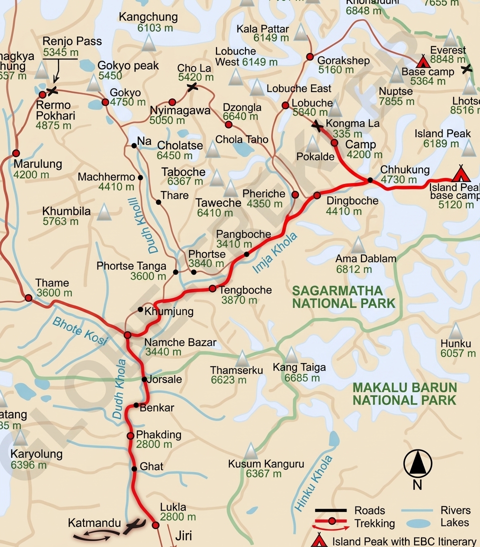
Route Map
Route map image could not be loaded
Showing route for Island Peak with Everest Base Camp
Route Information
Starting Point:Lukla
Ending Point:Lukla
Highest Point:Island Peak (Imja Tse) (6,189 m)
Key Locations
Lukla
Day 1
start
2,840 m
Namche Bazaar
Day 2
3,440 m
Tengboche
Day 4
3,860 m
Dingboche
Day 5
4,410 m
Lobuche
Day 7
4,940 m
Everest Base Camp
Day 8
landmark
5,364 m
Kala Patthar
Day 9
landmark
5,545 m
Island Peak Base Camp
Day 11
5,087 m
Island Peak summit
Day 12
landmark
6,189 m
Frequently Asked Questions
Island Peak, known locally as Imja Tse, is 6,189 m. Base camp is at 5,087 m and high camp at around 5,600 m. On the way in you also reach Everest Base Camp at 5,364 m and Kala Patthar at 5,545 m, which is how the acclimatisation is built.
Still have questions?
Our travel experts are here to help you plan the perfect trip. Get in touch with us for personalized advice.
Reviews & Ratings
—
0 reviews
5★
0
4★
0
3★
0
2★
0
1★
0
Share Your Experience
Have you completed this trek? Help other travelers by sharing your experience.