
Annapurna Region, Nepal
Khumai Danda Trek
Three days, one ridge, and Machhapuchhre close enough to pick out individual gullies — the shortest route from Pokhara to a genuine high viewpoint, on a trail the villages below built themselves.
Package Overview
Best Time to Visit
March to May, September to December
Guided & Permitted
Licensed, insured guide and all trekking permits included
The shortest honest route to a real mountain view
Most three-day treks out of Pokhara are compromises. You either drive most of the way and walk a little, or you walk hard and reach a hill that is pleasant rather than remarkable. Khumai Danda is the exception, for a geographical reason: the ridge runs directly towards Machhapuchhre, and Pokhara is closer to Machhapuchhre than it is to any other mountain of that size.
From the top at 3,245 m the fishtail summit is roughly twelve kilometres away. You can pick out individual gullies and the hanging ice under the south face. Compare that to Poon Hill, where every peak you photograph is thirty to forty kilometres off.
The trek is also, in trekking terms, almost brand new. It is promoted locally as the Machhapuchhre Model Trek, a name that came out of a village development effort rather than a marketing department, and the trail exists because the settlements below it cut and maintain it.
What "new trail" actually means for you
This matters more than the romance of it, so here it is plainly.
| Khumai Danda | An established trail like Poon Hill | |
|---|---|---|
| Lodges per night | One or two, sometimes a homestay | Six to twenty, with a choice |
| If a lodge is full | There is no second option | Walk next door |
| Menu | Dal bhat, noodles, eggs, little else | Full trekking menu |
| Trail marking | Sparse; forks are genuinely ambiguous | Obvious, signposted |
| Other trekkers | Often none all day | Constant |
| Water on the ridge | Carried or collected; limited | Piped and sold |
The sparse marking is the practical one. Above Hile Kharka the route crosses open grazing ground where the herders' paths and the trekking route look identical, and cloud comes up the valley in the afternoon. This is not a trail to attempt without a guide who has walked it, and that is not a sales line — it is the single most common reason people have a bad day here.
Machhapuchhre, and why nobody stands on top of it
Machhapuchhre is 6,993 m and has never been officially summited. In 1957 a British expedition led by Jimmy Roberts reached roughly 150 m below the top and stopped, having agreed not to set foot on the summit itself. The mountain has been closed to climbing ever since, sacred to Shiva and left alone.
It is worth knowing this while you are looking at it. Everything else on that skyline — Annapurna I, Annapurna South, Hiunchuli — has been climbed repeatedly. The one mountain directly in front of you, the most photographed in Nepal, has not, and will not be.
Where it sits against Mardi Himal
These two treks are neighbours on adjacent ridges and buyers compare them constantly, usually without being told the real difference.
| Khumai Danda | Mardi Himal | |
|---|---|---|
| Days | 3 | 4 |
| Highest point | 3,245 m (3,660 m with Korchon) | 4,500 m at Upper Viewpoint |
| Crowds | Very few | Busy; High Camp fills |
| Lodge standard | Basic, community-run | Established, comfortable |
| Closest view | Machhapuchhre south face | Machhapuchhre and the Mardi wall |
| Best for | Quiet, and a tight schedule | Higher altitude and reliable beds |
If you have four days and want the higher ridge with dependable lodges, take Mardi Himal. If you have three days, or you have done Mardi and want the same mountains without the traffic, this is the trek.
Difficulty: short is not the same as easy
Three days sounds gentle. The numbers are less gentle: you gain roughly 1,750 m from the roadhead to the ridge across two days, and you give all of it back on the third.
Day two is the one that surprises people — a steady climb of around 1,085 m on a forest trail that does not level off, finishing on exposed grazing ground where the wind picks up. Day three is a single long descent of nearly 1,800 m, which is a lot of downhill for one morning and the reason we recommend poles.
At 3,245 m altitude sickness is unlikely but not impossible, particularly given how fast you arrive. If you sleep badly and wake with a headache, tell your guide rather than pushing through the Korchon extension.
The Korchon extension, and when to take it
From Khumai Danda the ridge continues north to Korchon Danda at 3,660 m. It is an unremarkable walk on easy ground, two to three hours up, and it widens the view considerably — you gain the western Annapurnas and, on a clear morning, Dhaulagiri.
We offer it as a sunrise option on day three for anyone who slept well and is moving comfortably. It adds four to five hours to a day that already involves a 1,800 m descent, so it is a genuine decision rather than a formality, and we will tell you honestly on the morning whether we think you should.
Lodges, homestays and the Gurung villages below
You sleep at Hile Kharka (2,160 m) on night one and on the ridge at Khumai Danda on night two. Both are simple: a bed, blankets, a shared toilet, and a dining space with a stove. The kitchen cooks what is in the kitchen.
The villages at the foot of the trail — Lahachok and Ghachok — are working Gurung settlements that farm rather than host trekkers, which is exactly why the reception is warm rather than transactional. Nobody here has been asked the same question five thousand times.
Permits
The route sits inside the Annapurna Conservation Area, so you need:
- ACAP — Annapurna Conservation Area Project entry permit
- TIMS — Trekkers' Information Management System card
Both are included and arranged by us in Pokhara. Bring your passport and two passport photographs.
Season
October and November give the sharpest views of Machhapuchhre. March to May is warmer with rhododendron in the forest below Hile Kharka. December and January are clear and near-empty but genuinely cold on an exposed ridge with no heating. We advise against the monsoon months, when the ridge is in cloud and the trail — poorly marked at the best of times — becomes harder to follow.
Where this trek goes
- Pokhara — A lakeside town at 820 m with the Annapurnas 30 km away
Related activities: Trekking in Nepal.
Or compare every trip we run: all trekking and tour packages.
Trip Highlights
Machhapuchhre (6,993 m) from closer than any other three-day trek reaches
Khumai Danda ridge at 3,245 m, on open grazing land rather than in a village
Optional extension to Korchon Danda (3,660 m) for a wider Annapurna arc
A community-built trail with almost no other trekkers on it
Lahachok and Ghachok — working Gurung villages, not trekking stops
Three days from Pokhara, no flight, no long drive
Live Weather
Detailed Itinerary
1
Day 1: Pokhara to Lahachok, trek to Hile Kharka (2,160 m)
A short drive of around an hour and a half north-west to Lahachok, through Ghachok and the last of the farmland. Then four hours of walking, climbing steadily through terraced fields and into oak and rhododendron forest to the community lodge at Hile Kharka. It is a gentle introduction and you arrive with the afternoon to spare. First views of Machhapuchhre through the trees on the last stretch.
2
Day 2: Hile Kharka to Khumai Danda (3,245 m)
Four to five hours and the real work of the trek — around 1,085 m of climbing on a forest trail that rarely levels off, then out onto open grazing ground for the final push to the ridge. Above the treeline the route crosses herders' pasture where the paths multiply and the correct line is not obvious; afternoon cloud can arrive quickly. Khumai Danda itself is a ridge camp, not a village: a lodge, some grazing, and Machhapuchhre filling the northern sky.
3
Day 3: Khumai Danda to Pokhara, with optional Korchon Danda (3,660 m)
Sunrise from the ridge, with the option of continuing two to three hours north to Korchon Danda for a wider view taking in the western Annapurnas and, on a good morning, Dhaulagiri — a decision made on the day based on how you slept. Then the long descent, nearly 1,800 m back through the forest to the road, and a drive of an hour and a half to Pokhara. Six to eight hours of walking without the extension, nine to eleven with it.
Cost Details
What's Included
- Private vehicle, Pokhara to Lahachok and return
- All accommodation on trek, twin share in lodges and homestays
- Breakfast, lunch and dinner throughout the trek
- Rooms booked in advance, where options are limited to one lodge
- Licensed, insured English-speaking guide who has walked this route
- ACAP entry permit and TIMS card
- Guide wages, insurance, food and accommodation
- First aid kit carried by the guide
- Government taxes and company service charge
What's Not Included
- International flights and Nepal visa
- Travel insurance — must cover helicopter evacuation
- Accommodation and meals in Pokhara
- Porter — available on request at a daily rate
- Hot showers, charging and bottled drinks in lodges
- Personal trekking equipment, sleeping bag and poles
- Tips for guide and porter
- Any cost arising from early descent or trip changes
Essential Information
- Maximum altitude: 3,245 m
- Trip duration: 3 days
- Difficulty: moderate
- Best season: March to May, September to December
- Group size: 1 to 10 trekkers
- Permits: ACAP entry permit; TIMS card — all included and arranged by us
- Accommodation: Community lodges and homestays
- Guide: licensed and insured, English speaking
- Weather reference point: Ghachok
Important Cost Information
Payment Terms:
- • 25% deposit required to confirm booking
- • Balance payment due 30 days before departure
- • Full refund if cancelled 45+ days before
Fixed Departure Dates
Choose from our scheduled group departures with guaranteed departures.
Route Map
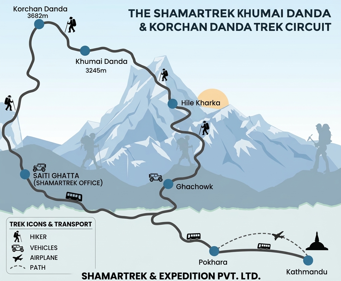
Route map image could not be loaded
Showing route for Khumai Danda Trek
Route Information
Starting Point:Lahachok
Ending Point:Lahachok
Highest Point:Khumai Danda (3,245 m)
Key Locations
Lahachok
Day 1
start
1,100 m
Hile Kharka
Day 1
2,160 m
Khumai Danda
Day 2
3,245 m
Lahachok
Day 3
end
1,100 m
Frequently Asked Questions
Khumai Danda is 3,245 m. The optional extension along the ridge to Korchon Danda reaches 3,660 m. You sleep on the ridge at Khumai Danda, which is the highest night of the trek.
Still have questions?
Our travel experts are here to help you plan the perfect trip. Get in touch with us for personalized advice.
Reviews & Ratings
—
0 reviews
5★
0
4★
0
3★
0
2★
0
1★
0
Share Your Experience
Have you completed this trek? Help other travelers by sharing your experience.