
Manaslu Region, Nepal
Manaslu Circuit Trek
Twelve days up the Budhi Gandaki and around Manaslu, the eighth-highest mountain on earth, finishing over the 5,106 m Larke La into the Annapurna trail.
Package Overview
Best Time to Visit
March to May, September to November
Guided & Permitted
Licensed, insured guide and all trekking permits included
The Annapurna Circuit as it was before the road
People say this often enough that it has become a cliché, and it also happens to be accurate. Manaslu is a single long walk up one river system to a high pass and down into different country on the far side — which is exactly what the Annapurna Circuit was before jeep tracks reached Manang and Muktinath.
The difference you will notice is not scenery, it is traffic. Restricted-area permits are expensive and must be arranged through an agency, and the effect is a 5,106 m pass crossing with a fraction of the people on it.
The trade is comfort. Expect plainer rooms than you would get on the popular trails, four days of hard walking before the views start, and a very short menu once you are past Samagaun.
Twelve days, and what that costs you
Most operators sell this in fourteen or fifteen days. We sell a twelve-day version and we will be straight about the difference, because it is the only thing that really separates the itineraries.
| This 12-day trip | The 14–15 day version | |
|---|---|---|
| Acclimatisation days | One, at Samagaun | Two — Samagaun and Samdo |
| Highest sleep before the pass | Dharamsala, 4,460 m | Same |
| Side trips | One, from Samagaun | Birendra Lake, Manaslu BC and Pungyen Gompa |
| Suits | Experienced trekkers on a tight schedule | A first trip above 5,000 m |
The single acclimatisation day at Samagaun is the one that matters most, and it stays. What the shorter trip loses is the second rest day at Samdo and the time for the other side walks.
If you have never been above 5,000 m, take the longer version — ask us and we will price it. If you have crossed a high pass before and your dates are tight, twelve days works and this is the honest way to do it.
Four permits, all in the price, and one rule that has changed
This trip carries more paperwork than any other we sell outside Dolpo, and all of it is in the quoted figure rather than payable on arrival. You are covered for the restricted-area permit, the conservation area, ACAP for the exit through Dharapani, and a TIMS card.
One thing is worth flagging because a great deal of published advice still gets it wrong. You no longer need a second trekker. Solo travellers used to be refused a restricted-area permit outright and turned back at the Jagat checkpost; that requirement ended in March 2026. We run this trek for single travellers now, and the only conditions still attached are that an agency applies for the permit and that you walk with a licensed guide — both of which are our job rather than yours.
Our permits guide sets out what every region requires.
Larke La is the longest pass day in Nepali teahouse trekking
This deserves its own section because people underestimate it, and because it is not the climb that catches them.
From Dharamsala at 4,460 m you start before dawn and climb four to five hours to the pass at 5,106 m. That part is cold and slow but straightforward. Then you descend more than 1,380 m to Bimthang, much of it on loose moraine, and the whole day runs to eight or nine hours.
It is longer than Thorong La and considerably longer than anything on the Everest trail. Trekking poles matter more here than anywhere else on this route, and so does starting on time.
The pass holds snow into spring and can close after heavy weather. We keep a spare margin in the itinerary for that, because the only alternative to crossing is walking the entire gorge back out.
The first four days are the ones to be ready for
People brace for the pass and are caught out by the approach. Days two to five do more climbing and descending than the profile implies, on trail that is narrow, exposed in places and consistently rougher underfoot than anything on the Annapurna or Everest trails.
There is also a psychological element worth naming: you are four days in before the country opens out and starts to look like the photographs. Until Namrung it is forest, river noise and suspension bridges. Trekkers who booked for mountain views sometimes wonder on day three whether they have made a mistake, and then day five arrives and the question stops.
The practical consequence is that your boots and knees get tested early, before altitude is a factor at all. Poles from day two, not day nine.
What to do with your day at Samagaun
The single acclimatisation day is at 3,530 m, and it is spent climbing rather than resting — several hundred metres up and back down to the same bed, which is the mechanism that gets you over Larke La four days later.
Your guide chooses between three walks on the morning, based on the weather and how the group is moving:
| Walk | Effort | Worth picking when |
|---|---|---|
| Birendra Lake | 2 hrs, easy | Someone in the group is struggling and needs a light day |
| Manaslu Base Camp | 6–7 hrs, hard | Everyone is moving well — far the best acclimatisation |
| Pungyen Gompa | 4–5 hrs, moderate | The middle option, and the best views of the glacier |
If you only remember one thing from this page: take the Base Camp walk if you can. The difference it makes on the pass is larger than anything else available to you.
How it compares with the Annapurna Circuit
| Manaslu Circuit | Annapurna Circuit | |
|---|---|---|
| Pass | Larke La, 5,106 m | Thorong La, 5,416 m |
| Permits | Restricted — agency and guide required | ACAP and TIMS only |
| Traffic | Light | Heavy in season |
| Lodges | Basic above Samagaun | Good throughout |
| Road intrusion | Minimal | Significant at both ends |
| Shortening it partway | Not practical | Easy |
Choose Manaslu for quiet and a continuous route. Choose the Annapurna Circuit for better lodges, no permit restrictions, and side trips like Tilicho. The Manaslu region guide covers both the circuit and the Tsum branch.
Adding Tsum on the way through
You pass the turning on day three. Tsum heads north where the main trail continues west, so bolting it on costs roughly six days and one more permit, with no ground walked twice.
Whether to do it is a question of what you want from the fortnight rather than of value for money. Tsum is a monastery valley at modest altitude; this is a pass crossing. Joined together they make an unusually complete trip, and separately they are each better than half of a rushed one. Tell us which you are leaning towards and we will say honestly whether the extra week earns its place for you.
When to book it
Two windows, and they are not interchangeable.
Autumn, from late September, is the safer bet for the pass and the busier one on the trail — which on this route still means quiet. Spring, March into May, is emptier and greener low down, with the real possibility that Larke La is still under snow in early April. If your dates fall in that first fortnight of spring, ask us what the pass has been doing before you commit; we will have had people over it that week.
We close bookings in winter, when the pass is impassable, and through the monsoon — and in the monsoon the reason is the lower gorge, not the pass. That stretch takes landslides, and it is four days long with no way around it.
Where this trek goes
- Kathmandu Valley — Seven UNESCO Monument Zones within an hour of each other
Related activities: Trekking in Nepal, Photography Tours in Nepal.
Or compare every trip we run: all trekking and tour packages.
Trip Highlights
Manaslu (8,163 m), the eighth-highest mountain in the world
Larke La (5,106 m) — the longest pass day in Nepali teahouse trekking
Days of narrow gorge trail above the Budhi Gandaki
Samagaun, Birendra Lake and the Manaslu Base Camp side walk
Restricted-area permits keep the trail far quieter than Annapurna
Finishes onto the Annapurna Circuit at Dharapani — no backtracking
Live Weather
Detailed Itinerary
1
Day 1: Kathmandu to Machha Khola (900 m)
Eight to nine hours by private jeep, west to Dhading Besi and then north up the Budhi Gandaki on a road that deteriorates steadily. A long, dusty day and the price of a trailhead this remote. Overnight in a simple lodge beside the river, with the gorge already closing in above the village.
2
Day 2: Machha Khola to Jagat (1,340 m)
Six to seven hours up the gorge, crossing and re-crossing on suspension bridges, past the hot springs at Tatopani. The trail is narrow in places and carved into the hillside well above the water. Jagat is a flagstoned village and the restricted-area checkpost — this is where the permit is registered and where the trail stops being public.
3
Day 3: Jagat to Deng (1,804 m)
Seven to eight hours and the longest day of the lower gorge. Past Philim, where the Tsum Valley trail branches north at Lokpa, and on through a narrowing canyon with the river loud below. Deng is a small village where the valley finally begins to open and the first mani walls appear beside the path.
4
Day 4: Deng to Namrung (2,630 m)
Six to seven hours climbing steadily as the country changes character entirely — pine and rhododendron replace the subtropical scrub, chortens appear, and the architecture turns Tibetan. Namrung sits above a gorge with a checkpost and the first clear views ahead to Himalchuli and Ganesh Himal. The air is noticeably cooler.
5
Day 5: Namrung to Lho (3,180 m)
Four to five hours through Lihi and Sho, past barley terraces and long mani walls, with Manaslu itself appearing ahead for the first time. Lho is a village of flat-roofed stone houses with Ribung Gompa above it — worth the short climb at the end of the afternoon for the view of the mountain at sunset.
6
Day 6: Lho to Samagaun (3,530 m)
Four to five hours through Shyala, where the valley opens into a broad bowl with Manaslu directly ahead and Himalchuli behind. A short day by design. Samagaun is the largest village on the route, a substantial Tibetan-culture settlement under the north face, and you have two nights here.
7
Day 7: Samagaun — acclimatisation day
Not a rest day. We climb several hundred metres and return to sleep at the same height, which is what makes the pass possible. Three choices depending on conditions and pace: Birendra Lake below the icefall, the harder climb to Manaslu Base Camp at around 4,800 m, or Pungyen Gompa on its shelf above the glacier. The Base Camp walk is the best acclimatisation of the three.
8
Day 8: Samagaun to Samdo (3,875 m)
Three to four hours up a widening, treeless valley past the turnoff to the Tibetan border trade route. Samdo is the last permanent village before the pass — a Tibetan settlement whose families crossed the border and resettled here, with yak pasture all around it. Short and deliberate: the altitude is gained slowly from here on.
9
Day 9: Samdo to Dharamsala (4,460 m)
Three to four hours and only about 600 m, but at this altitude that is enough. Dharamsala, also called Larkya Phedi, is not a village — it is a handful of basic buildings in an exposed bowl beneath the pass, cold and crowded in season. Early dinner and an attempt at sleeping, which few people manage well at 4,460 m.
10
Day 10: Larke La (5,106 m) to Bimthang (3,720 m)
The big day, and the longest pass day in Nepali teahouse trekking. Away before dawn for four to five hours of steady climbing on moraine and snow to the prayer flags at 5,106 m, with Himlung, Cheo Himal and Annapurna II opening out beyond. Then a descent of more than 1,380 m on loose ground to Bimthang — eight to nine hours in total, and far harder on the knees than the climb is on the lungs.
11
Day 11: Bimthang to Dharapani (1,860 m)
Six to seven hours dropping through rhododendron and pine into the Marsyangdi valley, losing nearly 1,900 m. The vegetation changes hour by hour and the air thickens with it. Dharapani is on the Annapurna Circuit trail, so the last hour is a strange re-entry into a world with other trekkers, bakeries and menus in it.
12
Day 12: Dharapani to Kathmandu
A jeep down the Marsyangdi to Besisahar, around four hours on rough road, then six to seven hours of progressively better highway to Kathmandu. A long day in a vehicle. If you would rather finish in Pokhara the drive is shorter and we can route you that way at no extra cost.
Cost Details
What's Included
- Private jeep, Kathmandu to Machha Khola and Dharapani to Kathmandu
- Manaslu Restricted Area Permit
- Manaslu Conservation Area permit, ACAP permit and TIMS card
- All teahouse accommodation on trek, twin share where rooms allow
- Breakfast, lunch and dinner throughout the trek
- An acclimatisation day at Samagaun with a guided side walk
- Licensed, insured English-speaking guide experienced on Larke La
- Guide wages, insurance, equipment, food and accommodation
- First aid kit and pulse oximeter carried by the guide
- Government taxes and company service charge
What's Not Included
- International flights and Nepal visa
- Travel insurance — must cover helicopter evacuation to 5,500 m
- Accommodation and meals in Kathmandu
- Porter — strongly recommended, available at a daily rate
- Tsum Valley extension, quoted separately
- Hot showers, wifi, charging and bottled drinks in lodges
- Personal trekking equipment and a sleeping bag rated to -15°C
- Tips for guide and porter
- Any cost arising from a closed pass, early descent or evacuation
Essential Information
- Maximum altitude: 5,106 m
- Trip duration: 12 days
- Difficulty: challenging
- Best season: March to May, September to November
- Group size: 1 to 10 trekkers
- Permits: Manaslu Restricted Area Permit — issued only through a registered agency; Manaslu Conservation Area permit; ACAP entry permit, because the circuit exits through the Annapurna area; TIMS card — all included and arranged by us
- Accommodation: Teahouses throughout, basic above Samagaun
- Guide: licensed and insured, English speaking
- Weather reference point: Samagaun
Important Cost Information
Payment Terms:
- • 25% deposit required to confirm booking
- • Balance payment due 30 days before departure
- • Full refund if cancelled 45+ days before
Fixed Departure Dates
Choose from our scheduled group departures with guaranteed departures.
Route Map
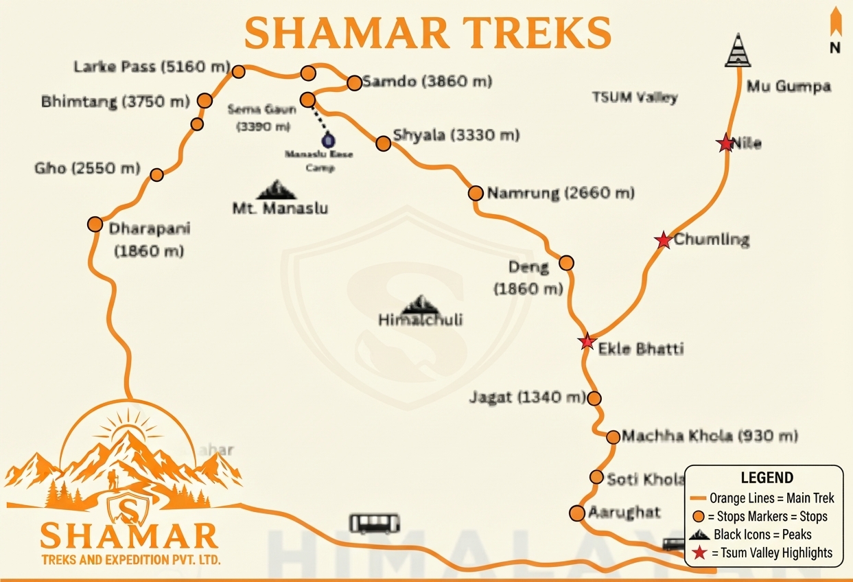
Route map image could not be loaded
Showing route for Manaslu Circuit Trek
Route Information
Starting Point:Machha Khola
Ending Point:Dharapani
Highest Point:Larke La (5,106 m)
Key Locations
Machha Khola
Day 1
start
900 m
Jagat
Day 2
1,340 m
Deng
Day 3
1,804 m
Namrung
Day 4
2,630 m
Lho
Day 5
3,180 m
Samagaun
Day 6
3,530 m
Samdo
Day 8
3,875 m
Dharamsala
Day 9
4,460 m
Larke La
Day 10
landmark
5,106 m
Bimthang
Day 10
3,720 m
Dharapani
Day 11
end
1,860 m
Frequently Asked Questions
Larke La is 5,106 m. What people underestimate is not the height but the shape of the day: a pre-dawn start from 4,460 m, then a descent of more than 1,380 m on loose moraine down to Bimthang. Eight to nine hours door to door, which makes it the longest single day of teahouse trekking anywhere in Nepal.
Still have questions?
Our travel experts are here to help you plan the perfect trip. Get in touch with us for personalized advice.
Reviews & Ratings
—
0 reviews
5★
0
4★
0
3★
0
2★
0
1★
0
Share Your Experience
Have you completed this trek? Help other travelers by sharing your experience.