
Annapurna Region, Nepal
Annapurna Base Camp Trek
Seven days up the Modi Khola into the Annapurna Sanctuary — a glacial amphitheatre at 4,130 m ringed by 7,000 m peaks, and the only trek in Nepal where you sleep inside one.
Package Overview
Best Time to Visit
March to May, October to November
Guided & Permitted
Licensed, insured guide and all trekking permits included
The only trek in Nepal where you sleep inside the mountains
Most Himalayan treks look at mountains from a distance or from a ridge. The Annapurna Sanctuary is different in a way that is hard to convey until you are standing in it: a narrow gorge opens into a glacial basin perhaps three kilometres across, and the wall around you is continuous — Annapurna I at 8,091 m, Annapurna South at 7,219 m, Hiunchuli, Gangapurna, and Machhapuchhre closing the gap behind.
You are not looking at an amphitheatre. You are in the middle of one, and you sleep there. There is no equivalent anywhere else in Nepal that a trekker can reach without technical ground.
Why this works in seven days when Everest needs fourteen
Annapurna Base Camp is 4,130 m. That is low for a base camp — over 1,200 m below Everest Base Camp, and more than 1,400 m below Kala Patthar.
The consequence is the whole commercial case for this trek. Below roughly 4,500 m the body copes with a steady ascent without needing a day standing still, so no acclimatisation day is required and nothing is being cut to make the itinerary short. The seven days are seven days of walking, not a compressed fourteen.
| Annapurna Base Camp | Everest Base Camp | |
|---|---|---|
| Days | 7 | 14 |
| Highest point | 4,130 m | 5,545 m |
| Acclimatisation days | None needed | Two, non-negotiable |
| Getting there | Road from Pokhara | Flight to Lukla |
| Risk of losing days | Minimal | High — Lukla cancels |
| The payoff | Sleeping inside the Sanctuary | Standing under the Khumbu Icefall |
The road to Kimche, and whether it ruined the trek
This comes up in forum threads often enough to answer directly. The trek used to start on foot at Birethanti, off the Pokhara–Baglung highway. A rough road now climbs to Kimche and on to Ghandruk, and a jeep track runs along the valley floor to Siwai. We drive to Kimche in two to three hours and walk out to Siwai at the end.
What the road removed were the two flattest, hottest, least interesting days of the old route — terraced farmland and a dusty river valley. What it did not touch is the part you came for. No vehicle goes above Siwai or Ghandruk. Everything from Chhomrong to the Sanctuary is on foot and always will be, because the gorge above it has no floor wide enough to put a road on.
Compare that with the Annapurna Circuit, where the road climbed all the way to Manang and genuinely changed the character of the walk. Here it stopped at the gate. It is the rare case where a road made a trek better by deleting its worst days.
The avalanche section, stated plainly
This is the part of the trek that matters most and the part most operator pages reduce to "some sections can be snowy". We would rather you booked with the facts.
Between Hinku Cave, Deurali and Machhapuchhre Base Camp the trail runs beneath steep open slopes that load with snow. It is the one genuinely hazardous stretch on the route, and it has killed trekkers:
- March 2001 — an avalanche between Hinku Cave and Deurali killed four Australian trekkers.
- January 2020 — an avalanche on the same stretch killed four South Korean trekkers and three Nepali guides.
Both happened in late winter or early spring, after snowfall, which is when the risk is highest. It is not a reason to avoid the trek — tens of thousands of people walk it safely every year — but it is a reason to care who you walk it with and when.
What we actually do about it
We cross that section early in the morning, before the sun warms and loosens the snowpack above. If there has been heavy recent snowfall, we do not cross it at all — we hold at Deurali or turn around, and that decision belongs to the guide on the day rather than to an office.
We also will not run this trek in February or early March after a heavy winter, which is the window both of those avalanches fell in. If you ask us for those dates we will tell you why we are saying no and offer you Poon Hill or Mardi Himal, which carry no comparable exposure.
The difficulty is stairs, not altitude
Nobody warns people about Chhomrong. The village sits on a steep hillside at 2,170 m, and the trail drops several hundred metres of stone staircase to the river at the bottom and climbs straight back up the other side — on the way in and again on the way out.
That, repeated, is the real work of this trek. There is no technical ground, the altitude is manageable, and what will actually ache on day three is the fronts of your thighs.
| Day | Walking | What makes it hard |
|---|---|---|
| 1 | 4–5 hrs | The climb to Chhomrong after a morning in a jeep |
| 2 | 5–6 hrs | Down the Chhomrong staircase and back up the far side |
| 3 | 5–6 hrs | Sustained climbing as the gorge narrows |
| 4 | 5–6 hrs | The avalanche section, then thin air for the last hour |
| 5 | 6–7 hrs | A long descent — this is the day for poles |
| 6 | 4–5 hrs | Chhomrong again, in reverse |
The one trek that still works in bad weather
Worth knowing if your dates are fixed and the forecast turns. Ridge treks — Mardi, Poon Hill, Khopra — are entirely about the view, and a day of cloud removes the reason you came.
The Sanctuary is enclosed. Walking up a gorge between vertical walls with cloud moving through it is atmospheric rather than disappointing, and the Base Camp bowl frequently clears at dawn even after a grey afternoon. It is the most weather-robust trek in the Annapurna region, and that is a genuine reason to choose it.
Machhapuchhre, which nobody has climbed
You spend a night at Machhapuchhre Base Camp, 3,700 m, below a 6,993 m peak that has never been officially summited. A British expedition under Jimmy Roberts reached about 150 m short of the top in 1957 and stopped by agreement, and the mountain has been closed to climbing ever since, sacred to Shiva.
Everything else on that skyline has been climbed repeatedly. The peak immediately above your lodge has not, and will not be.
The wall around you, named
Standing in the basin it is hard to work out what you are looking at, and no lodge has a board explaining it. This is the rim, clockwise from the south:
| Peak | Altitude | Note |
|---|---|---|
| Hiunchuli | 6,441 m | The south side of the entrance gorge |
| Annapurna South | 7,219 m | The one filling the window at Base Camp |
| Baraha Shikhar (Fang) | 7,647 m | The shoulder immediately left of Annapurna I |
| Annapurna I | 8,091 m | Tenth-highest mountain on earth |
| Tharpu Chuli (Tent Peak) | 5,663 m | The cone in the middle of the basin |
| Singu Chuli (Fluted Peak) | 6,501 m | Behind Tharpu Chuli |
| Gandharba Chuli | 6,248 m | Between Singu Chuli and Machhapuchhre |
| Machhapuchhre | 6,993 m | The north side of the entrance gorge |
Annapurna I is worth a minute of your attention. It was the first 8,000-metre peak ever climbed — Maurice Herzog and Louis Lachenal reached the summit on 3 June 1950, three years before Everest, on a French expedition that spent weeks simply finding the mountain because the available maps were wrong. They climbed it without supplementary oxygen and both lost fingers and toes to frostbite on the way down.
It has since become the mountain with the worst ratio of deaths to summits of all fourteen 8,000-metre peaks. The face responsible for that is the south face, and the south face is what you are sitting under.
Tharpu Chuli and Singu Chuli are both Nepal Mountaineering Association permitted peaks climbed from inside the basin. If you are thinking about a first Himalayan summit, ask us — but not on this itinerary, which has no spare days for it.
What Base Camp is actually like
Machhapuchhre Base Camp and Annapurna Base Camp are not villages. Nobody lives at either. They are clusters of a few lodges built for the season; staff walk up in September and come down after the spring, and in a bad winter the buildings take avalanche damage and get repaired before the next season.
Expect plywood partitions, no heating anywhere except the stove in the dining room, and a short menu. Burning firewood is not permitted inside the Sanctuary, so every pot of dal bhat is cooked on gas that somebody carried up the gorge on their back — which is also why a meal at 4,130 m costs several times what the same plate costs in Pokhara. Charging and hot water are paid for by the item. Mobile signal exists and is unreliable.
It will be below freezing on a clear night, in any month. Bring a bag rated properly rather than relying on lodge blankets.
Two things most people are not told. The first is the dawn: the rim is high enough that first light sits on the summits for the better part of an hour while the basin floor is still in shadow and genuinely cold, so the photograph everyone wants is taken standing in the dark. The second is on the moraine just above the lodges — memorial cairns and plaques for climbers killed on Annapurna, among them a chorten for Anatoli Boukreev, buried by an avalanche on the south face on 25 December 1997. It is a short walk and worth making.
Hot springs on the way out
Day six finishes at Jhinu Danda, where a twenty-minute walk down to the Modi Khola reaches stone pools fed by a hot spring. After five days of stone staircases this is not a gimmick, and it is the reason we route the descent this way rather than straight back to the roadhead.
Permits
- ACAP — Annapurna Conservation Area Project entry permit
- TIMS — Trekkers' Information Management System card
Both included and arranged by us in Pokhara. Bring your passport and two passport photographs. Checkpoints at Chhomrong and Jhinu record your entry and exit, which is also how search and rescue would locate you.
Season, and the months we decline
October and November are the most settled and the clearest. Late March to May is warm, with rhododendron through the forest below Chhomrong and the snow risk falling through the season.
December and January can be superb — cold, empty, sharp — but the Sanctuary holds snow and the upper lodges thin out. Ask us and we will give you an honest read on conditions rather than a booking.
February and early March after heavy snow is the window we decline, for the reasons set out above. The monsoon is poor here and the gorge section is landslide-prone when wet.
Combining it with Poon Hill
The two routes share the trail around Chhomrong and Ghandruk, so adding Ghorepani and Poon Hill costs about three extra days and gives you the sunrise viewpoint and the Sanctuary in one trip. It is the most common upgrade we are asked for and the one we most often recommend.
The Annapurna region guide compares every route here, from three-day foothill walks to the full circuit.
Where this trek goes
- Pokhara — A lakeside town at 820 m with the Annapurnas 30 km away
Related activities: Trekking in Nepal, Photography Tours in Nepal.
Or compare every trip we run: all trekking and tour packages.
Trip Highlights
Sleeping at 4,130 m inside a ring of 7,000 m peaks
Annapurna I (8,091 m) directly above the lodges at Base Camp
Machhapuchhre Base Camp (3,700 m) under the unclimbed fishtail summit
No acclimatisation day needed — which is why it fits in seven days
The Jhinu Danda hot springs on the walk out
A route that still works in cloud, unlike every ridge trek in Nepal
Live Weather
Detailed Itinerary
1
Day 1: Pokhara to Chhomrong (2,170 m)
Two to three hours by jeep to the roadhead at Siwai or Kimche, then four to five hours of walking up through Ghandruk or Jhinu to Chhomrong. The village is stacked down a steep hillside facing Annapurna South and Hiunchuli, and the view from the lodge terraces is the one that appears on most Annapurna postcards. It is also the last place on the trek with a genuine shop and reliable hot water.
2
Day 2: Chhomrong to Bamboo (2,310 m)
Five to six hours, and a day defined by stone. The trail drops several hundred steps to the Chhomrong Khola, crosses the suspension bridge and climbs all of it back up to Sinuwa on the far side before contouring into dense bamboo and rhododendron forest. The net height gain is barely 140 m; your legs will dispute that figure. Bamboo is a cluster of lodges in a forest clearing with no view at all.
3
Day 3: Bamboo to Deurali (3,230 m)
Five to six hours climbing steadily through Dovan and Himalaya as the gorge narrows and the walls close in on both sides. The forest thins into scrub and the air cools noticeably. Deurali at 3,230 m is the last stop before the avalanche-prone section, and where the guide makes the call on conditions for the morning. First night above 3,000 m.
4
Day 4: Deurali to Annapurna Base Camp (4,130 m) via Machhapuchhre Base Camp
Five to six hours, and we start early — the stretch past Hinku Cave towards Machhapuchhre Base Camp runs beneath steep snow-loaded slopes and is crossed before the sun softens them. Past MBC at 3,700 m the gorge finally opens and the Sanctuary reveals itself all at once. The last hour to Base Camp is slow in thin air and nobody minds. You sleep at 4,130 m inside the ring: Annapurna I above you, Machhapuchhre behind.
5
Day 5: Annapurna Base Camp to Bamboo (2,310 m)
Sunrise on Annapurna I first — the light reaches the summit long before it reaches the bowl, and it is worth the cold. Then a long descent of six to seven hours, losing more than 1,800 m back through Deurali, Himalaya and Dovan. Easy on the lungs and hard on the knees; this is the day poles earn their keep. The air thickens with every hour.
6
Day 6: Bamboo to Jhinu Danda (1,780 m)
Four to five hours back over the Chhomrong staircase — down, across, and up again, in reverse — then a descent to Jhinu Danda. A twenty-minute walk below the village reaches stone pools fed by a natural hot spring beside the Modi Khola. After five days of stone steps this is the most popular hour of the whole trek.
7
Day 7: Jhinu Danda to Pokhara
A short walk down to the roadhead at Siwai, around an hour, then a two to three hour drive back to Pokhara arriving around midday. If you would rather spend the morning at the hot springs we can push the drive to the afternoon — it makes no difference to us and it is a better last morning.
Cost Details
What's Included
- Private vehicle, Pokhara to the roadhead and return
- All lodge accommodation on trek, twin share
- Breakfast, lunch and dinner throughout the trek
- ACAP entry permit and TIMS card
- Licensed, insured English-speaking guide experienced on this route
- Guide wages, insurance, equipment, food and accommodation
- First aid kit carried by the guide
- Government taxes and company service charge
What's Not Included
- International flights and Nepal visa
- Travel insurance — must cover helicopter evacuation
- Accommodation and meals in Pokhara
- Porter — available on request at a daily rate
- Jhinu Danda hot spring entry fee
- Hot showers, wifi, charging and bottled drinks in lodges
- Personal trekking equipment and a sleeping bag rated to -10°C
- Tips for guide and porter
- Any cost arising from early descent, evacuation or trip changes
Essential Information
- Maximum altitude: 4,130 m
- Trip duration: 7 days
- Difficulty: moderate
- Best season: March to May, October to November
- Group size: 1 to 12 trekkers
- Permits: ACAP entry permit; TIMS card — all included and arranged by us
- Accommodation: Lodges throughout, twin share
- Guide: licensed and insured, English speaking
- Weather reference point: Annapurna Base Camp
Important Cost Information
Payment Terms:
- • 25% deposit required to confirm booking
- • Balance payment due 30 days before departure
- • Full refund if cancelled 45+ days before
Fixed Departure Dates
Choose from our scheduled group departures with guaranteed departures.
Route Map
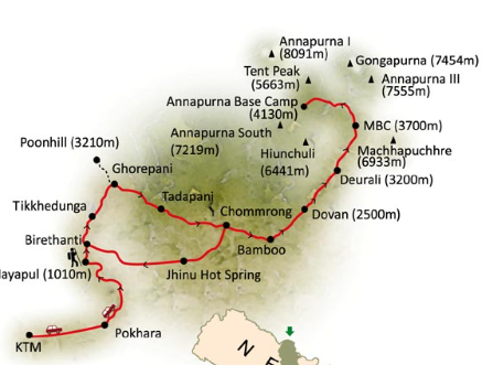
Route map image could not be loaded
Showing route for Annapurna Base Camp Trek
Route Information
Starting Point:Kimche
Ending Point:Siwai
Highest Point:Annapurna Base Camp (4,130 m)
Key Locations
Kimche
Day 1
start
1,640 m
Chhomrong
Day 1
2,170 m
Bamboo
Day 2
2,310 m
Deurali
Day 3
3,230 m
Machhapuchhre Base Camp
Day 4
landmark
3,700 m
Annapurna Base Camp
Day 4
4,130 m
Jhinu Danda
Day 6
1,780 m
Siwai
Day 7
end
1,520 m
Frequently Asked Questions
Annapurna Base Camp is 4,130 m, and you sleep there. Machhapuchhre Base Camp, where the gorge opens out, is 3,700 m. That is low by base camp standards — over 1,200 m below Everest Base Camp — which is precisely why this trek fits into seven days without an acclimatisation day.
Still have questions?
Our travel experts are here to help you plan the perfect trip. Get in touch with us for personalized advice.
Reviews & Ratings
—
0 reviews
5★
0
4★
0
3★
0
2★
0
1★
0
Share Your Experience
Have you completed this trek? Help other travelers by sharing your experience.