
Upper Mustang, Nepal
Upper Mustang Trek to Lo Manthang
Thirteen days north of the Himalaya into the old Tibetan kingdom of Lo — red cliffs, cave cities, and a walled capital at 3,840 m — and the one trek in Nepal that works during the monsoon.
Package Overview
Best Time to Visit
March to early November, including the monsoon months
Guided & Permitted
Licensed, insured guide and all trekking permits included
The trek that works when nothing else does
Upper Mustang sits north of the main Himalayan chain, in the rain shadow of Annapurna and Dhaulagiri. The monsoon that shuts down trekking across the rest of Nepal from June to August arrives here as cloud and very little water.
That single geographical fact makes this the most useful trek in the country. If your holiday falls in July, everything else we sell is either a wash-out or a bad idea, and Mustang is genuinely in season — dry, warm, and green in the irrigated village fields against red rock.
It is also, independently of the calendar, one of the two or three most interesting places in Nepal. The rain shadow that keeps the weather out kept the culture in: this was a separate Buddhist kingdom, closed to outsiders until 1992, and what survives is Tibetan in a way that Tibet itself, after the twentieth century, largely is not.
Lo Manthang, and the kingdom of Lo
Lo Manthang at 3,840 m is a walled town of whitewashed houses built around a former royal palace, laid out in the fifteenth century and still substantially intact. Its monasteries — Jampa Lhakhang and Thubchen among them — hold wall paintings of that period, some restored in recent decades and some not.
Mustang was a kingdom in its own right for centuries, then a semi-autonomous principality within Nepal. Nepal formally ended the monarchy's status in 2008. What that means for a visitor is a place where the architecture, the language, the religion and the agricultural year are Tibetan, inside Nepal, and where that has not been curated for you.
The sky caves, which are the strangest thing here
North of Lo Manthang at Chhoser, and in cliffs throughout the district, are thousands of man-made caves cut into vertical rock faces — some in clusters five storeys high, reachable now only by ladder, and originally connected internally.
Nobody is entirely certain why they were built. They have been used as burial chambers, as dwellings, as meditation cells and as refuges, and archaeological work in recent decades has found human remains and manuscripts dating back thousands of years. Standing at the bottom of a cliff with two hundred windows in it is one of the genuinely unexplained sights in the Himalaya.
We include a full day at Lo Manthang and a trip to the Chhoser caves, because arriving at the walled capital and turning round the next morning is the commonest mistake on this trek.
The permit, and what it costs you
Upper Mustang is a restricted area with the most expensive permit regime in Nepal outside Dolpo.
| Rule | What it means |
|---|---|
| Restricted Area Permit required | Agency issued only — you cannot buy one yourself |
| No minimum party size | The two-person rule was dropped in March 2026 |
| Licensed guide mandatory | A condition of the permit |
| Priced per person for a fixed period | Extra days beyond it cost more, per day |
| ACAP also required | Mustang sits within the Annapurna Conservation Area |
| Checked at Kagbeni | The boundary of the restricted zone |
The permit is a significant part of the price of this trek and it is included. It is also the reason Mustang is not crowded, and having seen what unrestricted access has done to other trails, we think that is money well spent rather than a tax.
How hard is it?
Moderate, and easier than most treks of this length. The maximum altitude is around 4,010 m at Nyi La, you sleep no higher than 3,840 m, and the daily walking is five to seven hours on good trails.
Three things make it tiring rather than difficult. The wind, which rises predictably through the middle of the day in the Kali Gandaki and blows dust; the aridity, which dehydrates you faster than you notice; and the profile, which rolls up and over ridge after ridge rather than climbing steadily. Most people find the wind the memorable part.
A jeep road now runs much of the way to Lo Manthang. We route away from it where a walking trail exists, and we tell you honestly that some sections share it.
The road, and being straight about it
This deserves its own section because it changes the trek and operators tend not to mention it. A rough road reaches Lo Manthang, and jeeps use it. You will see vehicles, and on some stretches you will walk on it.
We minimise that by using the old trails over the ridges where they survive, which is more climbing and better walking. Some clients ask us to build a jeep-supported version that drives the dull sections — we will do that on request and it turns this into a nine or ten day trip. We do not do it by default, because the walking between Ghami and Tsarang is the best part of the route.
Tiji, if your dates allow
The Tiji festival at Lo Manthang runs over three days in May and is the significant event in the Mustang year — masked dances in the palace square, monks from Choede monastery, and the whole district present.
It is the best time to be there and the hardest time to get a bed. If you want Tiji, contact us months rather than weeks ahead; the exact dates follow the Tibetan calendar and shift year to year, and accommodation in Lo Manthang is finite.
If May is the only month you have and Tiji is full, the Upper Mustang region page sets out what else is on in the valley, and the Annapurna Circuit shares the Jomsom road head if you would rather walk south instead. For a comparable Tibetan-culture trek at far greater length and remoteness, Upper Dolpo is the other side of the same coin.
Getting there
Drive or fly to Pokhara, then either the short flight to Jomsom or the long drive up the Kali Gandaki. The Jomsom flight is spectacular, takes twenty minutes, and is cancelled often — it flies early because the valley wind makes later landings unsafe.
We plan on the road and treat the flight as an upgrade, because a group stuck in Pokhara for two days waiting on weather has lost the trek rather than a morning.
Season
March to early November, which is a longer window than any other trek we run. May and June are excellent and warm. July and August work, which is the whole point — expect some cloud and a little rain rather than a monsoon. September to early November is clear, cold at night, and the best visibility.
Winter is the one to avoid: Lo Manthang is bitter, much of the population moves to lower ground for the season, and many lodges close.
Where this trek goes
- Upper Mustang — A former Tibetan kingdom in the rain shadow north of the Annapurnas
- Muktinath & Jomsom — A temple at 3,800 m held sacred by Hindus and Buddhists alike, in the arid Kali Gandaki valley
- Pokhara — A lakeside town at 820 m with the Annapurnas 30 km away
Related activities: Trekking in Nepal, Cultural & Heritage Tours.
Or compare every trip we run: all trekking and tour packages.
Trip Highlights
Lo Manthang (3,840 m), the walled capital of the old kingdom of Lo
The sky caves at Chhoser — hundreds of chambers cut into vertical cliff
Tibetan Buddhist monasteries with fifteenth-century wall paintings
Trekking in the Himalayan rain shadow, so the monsoon barely reaches it
The Kali Gandaki gorge, between Annapurna and Dhaulagiri
The Tiji festival at Lo Manthang, if your dates fall in May
Live Weather
Detailed Itinerary
1
Day 1: Kathmandu to Pokhara (820 m)
Six to seven hours by road west along the Prithvi highway, or a 25-minute flight at additional cost. An easy first day. Overnight beside Phewa lake, with the Annapurnas on the skyline if the weather is clear — the last comfortable hotel before the trek.
2
Day 2: Pokhara to Jomsom (2,720 m), trek to Kagbeni (2,810 m)
Either the early twenty-minute flight to Jomsom — dramatic, and cancelled often enough that we plan on the road instead — or a long jeep journey up the Kali Gandaki. Then two to three hours of easy walking to Kagbeni, a medieval-looking village of mud-brick alleyways at the mouth of the restricted zone. Permits are checked here.
3
Day 3: Kagbeni to Chele (3,050 m)
Five to six hours north up the Kali Gandaki, and the point at which the landscape stops looking like Nepal. Red and ochre cliffs, eroded pinnacles, almost no vegetation outside the irrigated fields. We pass Tangbe and Chhusang, and cross the river where the gorge narrows dramatically. The afternoon wind arrives on schedule.
4
Day 4: Chele to Syangboche (3,800 m)
Six to seven hours over a series of passes — Taklam La and Dajori La among them — with long views back down the Kali Gandaki towards Nilgiri and Tilicho. This is the day the trek settles into its rhythm of up over a ridge, down to a village, up again. Syangboche is a small settlement in a bowl.
5
Day 5: Syangboche to Ghami (3,520 m) over Nyi La (about 4,010 m)
Five to six hours and the high point of the trek at Nyi La, which is a broad pass rather than a summit and gives the first proper sense of the Mustang plateau opening northwards. Then down to Ghami, a green oasis of a village with one of the longest mani walls in Nepal on the way out of it.
6
Day 6: Ghami to Tsarang (3,560 m)
Four to five hours across the mani wall and over a ridge into Tsarang, a substantial village with a five-storey former fortress and a monastery holding a significant collection of thangkas and manuscripts. The best walking on the route is in this section, which is why we keep it on the old trail rather than the road.
7
Day 7: Tsarang to Lo Manthang (3,840 m)
Five to six hours over the Lo La and down to the walled capital, which appears below you all at once — whitewashed houses inside a wall, the old palace above them, and the whole Mustang plain behind. It is one of the great arrivals in Nepali trekking. Afternoon to walk the alleyways inside the walls.
8
Day 8: Lo Manthang — monasteries and the town
A full day, which is the point of a thirteen-day itinerary rather than an eleven-day one. Jampa Lhakhang and Thubchen hold fifteenth-century wall paintings, some restored and some not; the former royal palace dominates the square; and Choede monastery is the working religious centre. Time also simply to sit in the square, which tells you more than any of it.
9
Day 9: Chhoser sky caves, return to Lo Manthang
A day trip north towards the Tibetan border to the cave complexes at Chhoser — thousands of chambers cut into vertical cliff, some clusters five storeys high and reachable only by ladder. Nobody is certain why they were built; excavation has found human remains and manuscripts thousands of years old. Four to five hours of walking, or by jeep if you prefer.
10
Day 10: Lo Manthang to Ghami
Six to seven hours retracing the route south over the Lo La, or by the alternative eastern trail via Ghar Gompa — one of the oldest monasteries in Nepal, pre-dating the Buddhist establishment at Lo Manthang — which we take when conditions and group pace allow. Back to Ghami for the night.
11
Day 11: Ghami to Chhusang (2,980 m)
Six to seven hours back over Nyi La and down the series of ridges, losing altitude steadily and gaining oxygen and warmth with it. The wind is behind you in this direction, which makes a larger difference than it sounds. Chhusang sits at the confluence with the Narshing Khola.
12
Day 12: Chhusang to Jomsom via Kagbeni
Five to six hours down the Kali Gandaki out of the restricted zone, with the permit checked again at Kagbeni. An optional detour to Muktinath, sacred to both Hindus and Buddhists, if the group wants it and the timing works. Overnight in Jomsom — hot shower, a proper meal, and the end of the walking.
13
Day 13: Jomsom to Pokhara, and Kathmandu
The early Jomsom to Pokhara flight if it is running, or the long jeep down the Kali Gandaki, then on to Kathmandu by road or air. We build the day to absorb a cancelled Jomsom flight, because the wind in that valley decides the schedule and no amount of planning changes it.
Cost Details
What's Included
- Upper Mustang Restricted Area Permit
- ACAP entry permit and TIMS card
- All road transport, Kathmandu to Pokhara and Pokhara to Jomsom and return
- All lodge and guesthouse accommodation on trek, twin share
- Breakfast, lunch and dinner throughout the trek
- Two full days at Lo Manthang, including the Chhoser sky caves
- Licensed, insured English-speaking guide familiar with the monasteries of Lo
- Guide wages, insurance, food and accommodation
- First aid kit carried by the guide
- Government taxes and company service charge
What's Not Included
- International flights and Nepal visa
- Travel insurance — must cover helicopter evacuation
- Accommodation and meals in Kathmandu and Pokhara beyond the listed nights
- Optional Pokhara to Jomsom and Kathmandu to Pokhara flights
- Porter — available on request at a daily rate
- Monastery entry fees and donations
- Hot showers, wifi, charging and bottled drinks in lodges
- Personal trekking equipment and sleeping bag
- Tips for guide and porter
- Any cost arising from flight cancellation, early descent or trip changes
Essential Information
- Maximum altitude: 4,010 m
- Trip duration: 13 days
- Difficulty: moderate
- Best season: March to early November, including the monsoon months
- Group size: 2 to 12 trekkers
- Permits: Upper Mustang Restricted Area Permit — issued only through a registered agency; ACAP entry permit; TIMS card — all included and arranged by us
- Accommodation: Lodges and guesthouses throughout, twin share
- Guide: licensed and insured, English speaking
- Weather reference point: Lo Manthang
Important Cost Information
Payment Terms:
- • 25% deposit required to confirm booking
- • Balance payment due 30 days before departure
- • Full refund if cancelled 45+ days before
Fixed Departure Dates
Choose from our scheduled group departures with guaranteed departures.
Route Map
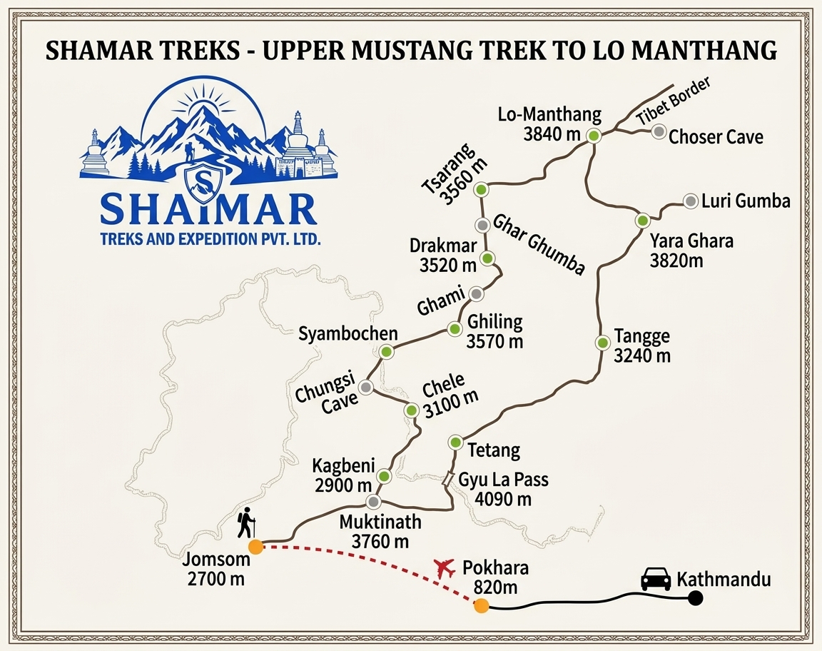
Route map image could not be loaded
Showing route for Upper Mustang Trek to Lo Manthang
Route Information
Starting Point:Kagbeni
Ending Point:Jomsom
Highest Point:Nyi La (4,010 m)
Key Locations
Kagbeni
Day 2
start
2,810 m
Chele
Day 3
3,050 m
Syangboche
Day 4
3,800 m
Nyi La
Day 5
landmark
4,010 m
Ghami
Day 5
3,520 m
Tsarang
Day 6
3,560 m
Lo Manthang
Day 7
3,840 m
Jomsom
Day 12
end
2,720 m
Frequently Asked Questions
Yes, and it is the main reason to choose it in July or August. Upper Mustang sits north of the main Himalayan chain in the rain shadow of Annapurna and Dhaulagiri, so the monsoon arrives as cloud and comparatively little rain. It is genuinely in season when almost nothing else in Nepal is.
Still have questions?
Our travel experts are here to help you plan the perfect trip. Get in touch with us for personalized advice.
Reviews & Ratings
—
0 reviews
5★
0
4★
0
3★
0
2★
0
1★
0
Share Your Experience
Have you completed this trek? Help other travelers by sharing your experience.