
Langtang Region, Nepal
Langtang Valley Trek
Eight days into the valley directly north of Kathmandu — glacier-head scenery at Kyanjin Gompa, a 4,985 m viewpoint above it, and a community that rebuilt the whole village after 2015.
Package Overview
Best Time to Visit
March to May, September to December
Guided & Permitted
Licensed, insured guide and all trekking permits included
The high valley you can reach without an aeroplane
Everest needs a flight to Lukla that weather cancels for days at a time. Annapurna needs a drive to Pokhara and then another drive beyond it. Langtang starts with one road journey from Kathmandu, and by the third afternoon you are sleeping at 3,430 m under a 7,000 m peak.
That is the practical case for this trek and it is a strong one. The scenic case is stronger: the valley narrows and then opens into a flat glacial trough at Kyanjin Gompa, ringed by ice, with Langtang Lirung (7,227 m) standing more or less directly above the lodges. Very few treks in Nepal put a mountain that size that close to where you sleep.
What happened here in 2015, and how to visit well
On 25 April 2015 the Gorkha earthquake shook a hanging glacier and a vast section of mountainside down onto Langtang village. The settlement was buried. Several hundred people died — villagers, lodge staff, trekkers, and porters — and effectively every family in the valley lost someone.
The village you walk through today was rebuilt on safer ground beside the debris field. You will pass a memorial wall carrying the names. It is not a viewpoint and it is not a photo stop.
Two things worth understanding. First, this valley chose to rebuild around trekking, and the money you spend in a Langtang lodge is not an abstraction — it is the reconstruction. Second, the people hosting you are generally willing to talk about it and often want to; they simply prefer to be asked rather than filmed. Follow their lead and this becomes the most human trek in Nepal.
The drive is the hard part, and nobody says so
Seven to eight hours from Kathmandu to Syabrubesi, and only the first stretch is comfortable. The road climbs out of the valley, deteriorates, and spends several hours as a rough single track with long drops and no barrier. It is dusty in autumn and slow in the wet.
We use a private jeep rather than the public bus. It is not luxury — it is suspension, a driver who does this road weekly, and the ability to stop. If you are prone to motion sickness, take something before you leave Kathmandu rather than an hour in.
Say so at booking if you would rather avoid the road entirely: a helicopter to Syabrubesi or Kyanjin is possible at additional cost, and for clients short on days it is occasionally the sensible choice.
Difficulty and the altitude shape
Moderate. The trail is a well-graded forest path for the first two days with no technical ground anywhere, and the daily distances are reasonable. What makes it a real trek is the profile.
| Day | Walking | Sleeping altitude | Gain |
|---|---|---|---|
| 2 | 5–6 hrs | 2,470 m | +920 m |
| 3 | 5–6 hrs | 3,430 m | +960 m |
| 4 | 3–4 hrs | 3,870 m | +440 m |
| 5 | 7–8 hrs | 3,870 m | +1,115 m and back down |
Day four is deliberately short. It exists so that you arrive at Kyanjin with the afternoon free and sleep one night at 3,870 m before attempting a 4,985 m climb, rather than doing both on the same day. Operators who merge days four and five to save a night are selling you a worse chance at the viewpoint.
Tserko Ri or Kyanjin Ri — pick the right one
There are two viewpoints above Kyanjin Gompa and clients are regularly sold the wrong one.
| Kyanjin Ri | Tserko Ri | |
|---|---|---|
| Altitude | About 4,300 m | About 4,985 m |
| Round trip | 2–3 hrs | 7–8 hrs |
| Gain | Around 430 m | Around 1,115 m |
| The view | Down the valley and onto Langtang Lirung | The full glacier head and into Tibet |
| Take it if | You arrived tired or short of breath | You slept well and want the real thing |
Tserko Ri is the better day by a wide margin and it is a genuine 5,000 m morning — cold, long, and unforgiving of a bad night. We build the day in and decide on the morning. Kyanjin Ri is not a consolation prize; it is a good short walk and the fallback we actually use.
Cheese, yaks and the thing to buy at the top
Kyanjin has a cheese factory that has been running since the 1950s, set up with Swiss assistance as part of an early Nepali dairy programme, and it still makes hard yak cheese by hand from the herds grazing the flats around the settlement.
You can visit it, and you should buy some. It is excellent, it is the only local industry up here that does not depend on trekkers turning up, and carrying a wedge of it down the valley is a considerably better souvenir than a printed T-shirt from Thamel.
Where it sits against the bigger treks
Langtang is the answer to "I have eight or nine days and I want a proper Himalayan valley."
| Langtang | Everest Base Camp | Annapurna Base Camp | |
|---|---|---|---|
| Days needed | 8 | 14–16 | 9–12 |
| Internal flight | None | Lukla, weather-dependent | None |
| Highest point | 4,985 m (day walk) | 5,545 m | 4,130 m |
| Crowds | Light | Heavy | Moderate |
| Nearest big peak | Langtang Lirung, very close | Everest, distant until Kala Patthar | A ring of 7,000 m peaks |
If you want the same region with homestays instead of lodges and no other foreigners at all, the Ruby Valley trek starts from the same road head and turns west.
Permits
Two, both included and arranged by us in Kathmandu before departure:
- Langtang National Park entry permit
- TIMS — Trekkers' Information Management System card
Bring your passport and two passport photographs. The park checkpoint at Dhunche records every entry and exit, which is also how search and rescue would find you.
Season
October and November are the clearest and the valley is busy by Langtang standards, which still means quiet. March to May brings rhododendron through the forest sections and warmer nights, with more afternoon cloud on the peaks.
December works and is spectacularly clear, but Kyanjin is bitter and some lodges close. We would rather tell you which are open than have you find out at 3,870 m. The monsoon brings landslides onto the Syabrubesi road, and that is the reason to avoid it here — the road, more than the rain.
Where this trek goes
- Kathmandu Valley — Seven UNESCO Monument Zones within an hour of each other
Related activities: Trekking in Nepal, Photography Tours in Nepal.
Or compare every trip we run: all trekking and tour packages.
Trip Highlights
Kyanjin Gompa (3,870 m) at the head of the valley, under Langtang Lirung
Tserko Ri (about 4,985 m) — a 5,000 m viewpoint reached as a day walk
Langtang Lirung (7,227 m) closer than any comparable trek puts a 7,000 m peak
A working yak cheese factory at Kyanjin, running since the 1950s
Tamang villages, and a valley rebuilt by the people who lost it
No internal flight — a drive from Kathmandu and you are walking
Live Weather
Detailed Itinerary
1
Day 1: Kathmandu to Syabrubesi (1,550 m)
Seven to eight hours by private jeep, north-west out of the Kathmandu valley and then up the Trishuli gorge. The sealed section ends early and the rest is rough, narrow and slow, with long drops below the road. It is a genuinely tiring day and the reason we do not also ask you to walk. Overnight in a lodge at Syabrubesi, a small roadhead town on the river.
2
Day 2: Syabrubesi to Lama Hotel (2,470 m)
Five to six hours and the first real walking. The trail crosses the Bhote Koshi and climbs into dense forest — oak, bamboo and moss, with langur monkeys common in the canopy and the river loud below you all day. Lama Hotel is not a hotel but a cluster of lodges in a forest clearing with no view to speak of, which makes the next morning a surprise.
3
Day 3: Lama Hotel to Langtang village (3,430 m)
Five to six hours, climbing steadily as the trees thin and the valley finally opens. Ghoda Tabela, an army checkpost with a lunch stop, is where the mountains first appear properly. The afternoon crosses the debris field left by the 2015 landslide and enters the rebuilt village. A memorial wall carries the names of those who died. Overnight in a lodge run, in most cases, by a family who survived it.
4
Day 4: Langtang village to Kyanjin Gompa (3,870 m)
A deliberately short day — three to four hours through yak pasture and past long mani walls, with the valley flattening out into a glacial trough. You arrive by lunchtime, which is the point: the afternoon is for the monastery, the cheese factory and doing nothing at altitude. Langtang Lirung stands more or less over the settlement.
5
Day 5: Tserko Ri (about 4,985 m), return to Kyanjin Gompa
The big day. Seven to eight hours round trip and around 1,115 m of climbing on a steep but non-technical path, starting before dawn to be on top for the clear morning air. From the summit the whole glacier head opens out, with the Tibetan border ridge beyond. Whether we go is decided that morning on how you slept — the shorter Kyanjin Ri is the alternative, not a punishment. Back to the same lodge.
6
Day 6: Kyanjin Gompa to Lama Hotel (2,470 m)
Six to seven hours retracing the valley, which walks completely differently downhill and with the light behind you. Long descent, easy underfoot, and a chance to spend properly in the village lodges you passed on the way up.
7
Day 7: Lama Hotel to Syabrubesi (1,550 m)
Four to five hours back down through the forest to the roadhead. A short day by design, so that an afternoon delay does not turn into a night on the trail. Hot shower, a beer if you want one, and the last night in the hills.
8
Day 8: Syabrubesi to Kathmandu
The road again, seven to eight hours, arriving in Kathmandu in the late afternoon. We aim for an early start because the road is better driven in the morning and because the day is long. Drop-off at your hotel.
Cost Details
What's Included
- Private jeep, Kathmandu to Syabrubesi and return
- All lodge accommodation on trek, twin share
- Breakfast, lunch and dinner throughout the trek
- Licensed, insured English-speaking trekking guide
- Langtang National Park entry permit and TIMS card
- Guide wages, insurance, equipment, food and accommodation
- First aid kit and pulse oximeter carried by the guide
- Government taxes and company service charge
What's Not Included
- International flights and Nepal visa
- Travel insurance — must cover helicopter evacuation to 5,000 m
- Accommodation and meals in Kathmandu
- Porter — available on request at a daily rate
- Optional helicopter transfer in place of the road journey
- Hot showers, wifi, battery charging and bottled drinks in lodges
- Personal trekking equipment and sleeping bag
- Tips for guide and porter
- Any cost arising from early descent, evacuation or trip changes
Essential Information
- Maximum altitude: 4,985 m
- Trip duration: 8 days
- Difficulty: moderate
- Best season: March to May, September to December
- Group size: 1 to 12 trekkers
- Permits: Langtang National Park entry permit; TIMS card — all included and arranged by us
- Accommodation: Lodges on trek, twin share
- Guide: licensed and insured, English speaking
- Weather reference point: Kyanjin Gompa
Important Cost Information
Payment Terms:
- • 25% deposit required to confirm booking
- • Balance payment due 30 days before departure
- • Full refund if cancelled 45+ days before
Fixed Departure Dates
Choose from our scheduled group departures with guaranteed departures.
Route Map
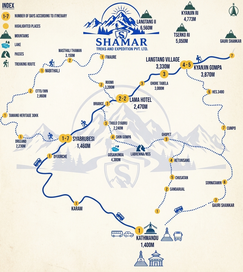
Route map image could not be loaded
Showing route for Langtang Valley Trek
Route Information
Starting Point:Syabrubesi
Ending Point:Syabrubesi
Highest Point:Tserko Ri (4,985 m)
Key Locations
Syabrubesi
Day 1
start
1,550 m
Lama Hotel
Day 2
2,470 m
Langtang village
Day 3
3,430 m
Kyanjin Gompa
Day 4
3,870 m
Tserko Ri
Day 5
viewpoint
4,985 m
Syabrubesi
Day 7
end
1,550 m
Frequently Asked Questions
You sleep no higher than Kyanjin Gompa at 3,870 m. The highest point is the Tserko Ri viewpoint at about 4,985 m, reached as a day walk and returned from the same day, which is a much safer way to touch 5,000 m than sleeping there.
Still have questions?
Our travel experts are here to help you plan the perfect trip. Get in touch with us for personalized advice.
Reviews & Ratings
—
0 reviews
5★
0
4★
0
3★
0
2★
0
1★
0
Share Your Experience
Have you completed this trek? Help other travelers by sharing your experience.