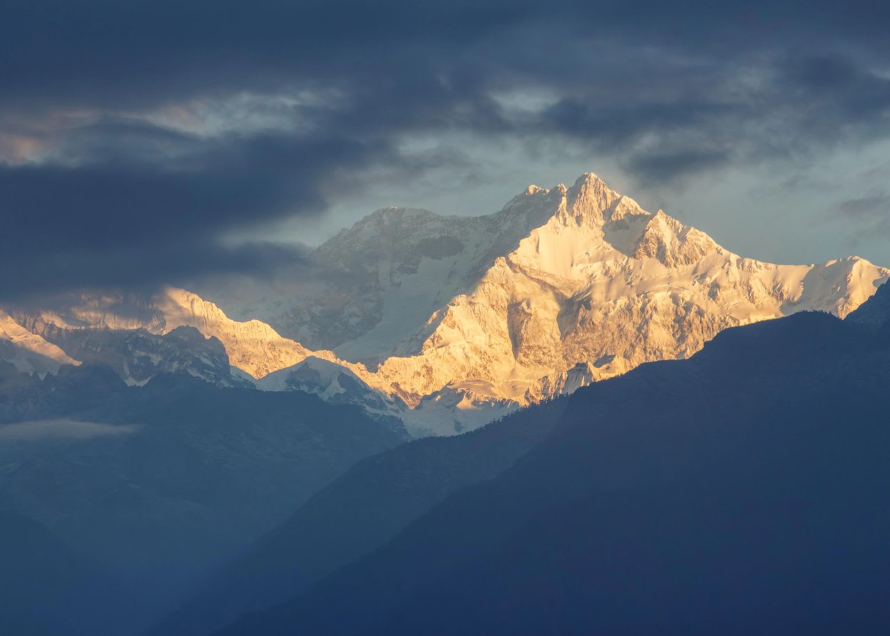
Kanchenjunga, Nepal
Kanchenjunga Base Camp Trek
Twenty days to the foot of the third-highest mountain on earth, reaching both the north base camp at Pangpema (5,143 m) and the southern viewpoint at Oktang — the longest walk-in of any trek we run.
Package Overview
Best Time to Visit
March to May, September to November
Guided & Permitted
Licensed, insured guide and all trekking permits included
Two base camps, one mountain, twenty days
Kanchenjunga is 8,586 m and the third-highest mountain on earth. It sits in the far east of Nepal against the Sikkim border, about as far from Kathmandu as it is possible to get and still be in the country, and it is guarded by the longest approach of any trek we sell.
What makes this route unusual is that it reaches both base camps. Pangpema on the north side sits at 5,143 m directly under the north face. Oktang on the south looks up the Yalung glacier at the face that the 1955 first ascent climbed. No other trek in Nepal puts you at two base camps of the same eight-thousander, and the two are entirely different experiences.
The summit nobody stands on
Worth knowing while you are looking at it. When Joe Brown and George Band made the first ascent in 1955, they stopped a few feet short of the true summit and did not step onto the highest point. The expedition had given an undertaking to the Chogyal of Sikkim that the summit — sacred to the people on both sides of the range — would remain untrodden.
Most expeditions since have honoured it. It is a rare thing in mountaineering: a convention with no enforcement behind it that has largely held for seventy years.
The permit rules, which are strict
Kanchenjunga is a restricted area and this is not a formality.
| Requirement | What it means |
|---|---|
| Restricted Area Permit | Issued only through a registered Nepali agency — never to an individual |
| No minimum party size | Since March 2026 a solo trekker can be permitted individually |
| Licensed guide mandatory | A condition of the permit, not a recommendation |
| KCAP required | Kanchenjunga Conservation Area entry permit, alongside the RAP |
| Fixed dates | The permit names your dates; changing them means re-issuing |
All permits are included in the price and handled by us. The old requirement for two trekkers on one restricted-area permit was removed in March 2026, so a solo traveller can now be permitted — though the permit still has to be issued through a registered agency and a licensed guide is still required.
A conservation area the community runs
The Kanchenjunga Conservation Area is managed by local community councils rather than directly by the national parks department, which is unusual in Nepal and visible on the ground: the lodges, the trail maintenance and the enforcement of grazing and firewood rules are local decisions.
It is also serious snow leopard country — one of the more important habitats in the eastern Himalaya, along with red panda in the forest below Ghunsa. You will almost certainly not see either. The point is that the habitat is intact enough that the question is reasonable.
How hard is it?
Challenging, and the hardest thing about it is duration rather than any single day.
Twenty days, of which roughly sixteen are walking, most of them six to eight hours. You sleep above 3,400 m for over a week and reach 5,143 m at Pangpema. The trails are long, remote and in places rough — this is not a maintained highway like the Khumbu trail, and sections between Sekathum and Ghunsa cross landslide-prone ground.
There is no technical ground and you need no equipment beyond boots, poles and proper cold-weather clothing. What you need is the fitness to walk for sixteen days without a rest day feeling like a necessity, and the temperament to be a long way from help.
North and south — why they feel different
| Pangpema (north) | Oktang (south) | |
|---|---|---|
| Altitude | 5,143 m | About 4,730 m |
| Approach | Ghunsa and Lhonak, glacier moraine | Yalung glacier from Ramche |
| The view | The north face, vast and close | The face climbed in 1955 |
| Feel | Bleak, high, exposed | Greener, more enclosed |
| Weather risk | Higher — more altitude, more wind | Lower |
Most operators sell one or the other. Doing both means crossing between the two valleys — either over the high Sele La ridge, which is the classic full circuit, or by descending and re-ascending. Our twenty-day itinerary takes in the north base camp and the southern viewpoint with the Sele La crossing, which is the version worth doing.
It is worth being clear about the cost of that choice. Going to one base camp only would save four or five days and a serious ridge crossing, and some clients ask for it. We will quote it, but we will also say that the two sides are the interesting part — seeing one face of Kanchenjunga and not the other is a bit like reading half a book.
Where it sits against the other long treks
This is the longest walk-in of anything we run, and buyers comparing it against our other big trips usually want to know what distinguishes them rather than which is hardest.
| Kanchenjunga | Makalu | Dhaulagiri | |
|---|---|---|---|
| Days | 20 | 19 | 16 |
| Highest point | 5,143 m | 4,870 m | 5,360 m |
| Accommodation | Lodges throughout | Lodges, then tents | Ten nights camping |
| Restricted permit | Yes | No | No |
| Hardest element | Duration and the Sele La | Three passes in one day | Two 5,000 m passes, no exit |
If lodges every night matter to you, this is the one to take — Makalu Base Camp puts you in tents in the upper valley and Dhaulagiri is a full camping expedition.
Getting there, which takes two days
A flight from Kathmandu to Bhadrapur in the far-eastern Terai, then a long drive up to Taplejung, then a jeep on rough road to the roadhead at Sekathum. It is the best part of two days before you start walking.
The Bhadrapur flight is the weak link, as domestic flights in Nepal generally are. We build a spare day into the return, and we would repeat the standard advice: do not book your international departure for the morning after you are due back in Kathmandu.
Lodges, and where they thin out
Simple teahouses run most of the route, which is more than the Makalu or Dhaulagiri approaches offer. Ghunsa is the largest settlement and the most comfortable night above the roadhead. Above it — at Khambachen, Lhonak and Pangpema — the lodges are rudimentary, seasonal, and few.
Capacity at Lhonak and Pangpema is genuinely limited and in October it is tight. We book, and we carry a contingency, because being turned away at 4,800 m is not a situation to discover on the day.
Season
Late September to November is the strongest window: settled weather, the high camps open, and the best chance of clear mornings at Pangpema. March to May works well and is the better season for rhododendron in the forest below Ghunsa, with more afternoon cloud on the peaks.
Winter closes the high camps entirely. The monsoon makes the Sekathum to Ghunsa section genuinely hazardous with landslides, and we do not run it then.
Where this trek goes
- Kanchenjunga — Three weeks into Nepal's far eastern corner to the base of the world's third-highest mountain
- Kathmandu Valley — Seven UNESCO Monument Zones within an hour of each other
Related activities: Trekking in Nepal.
Or compare every trip we run: all trekking and tour packages.
Trip Highlights
Kanchenjunga (8,586 m), the third-highest mountain in the world
Pangpema north base camp at 5,143 m, beneath the north face
Oktang, the southern viewpoint below the Yalung glacier
The only trek in Nepal reaching two base camps of one 8,000 m peak
Ghunsa and the Sherpa and Limbu villages of the far east
A community-managed conservation area with genuine snow leopard habitat
Live Weather
Detailed Itinerary
1
Day 1: Kathmandu to Bhadrapur, drive to Taplejung (1,820 m)
A morning flight to Bhadrapur in the far-eastern Terai near the Indian border, then eight to nine hours by road climbing north through tea country into the hills. A long travel day, and the tea gardens around Ilam on the way up are worth the window seat. Overnight in Taplejung.
2
Day 2: Taplejung to Sekathum (1,660 m)
Four to five hours by jeep on rough road down and along the Tamor river to the roadhead at Sekathum. Restricted area permits are registered here and this is where vehicles stop. A short day by design — the walking starts tomorrow and there is no advantage in arriving tired.
3
Day 3: Sekathum to Amjilosa (2,510 m)
Six to seven hours up the Ghunsa Khola on a narrow trail cut into the gorge side, crossing suspension bridges and climbing steeply in the last section. Sections of this stretch cross landslide ground and it is the least stable trail on the trek. Amjilosa is a tiny settlement on a shelf above the river.
4
Day 4: Amjilosa to Gyabla (2,730 m)
Five to six hours through dense forest with waterfalls off the valley walls, the gorge gradually widening as you climb. This is red panda country, though the odds are firmly against you. Gyabla is a small Sherpa settlement and the vegetation starts to feel Tibetan rather than subtropical from here.
5
Day 5: Gyabla to Ghunsa (3,430 m)
Five to six hours climbing into open country as the pines thin and the valley broadens. Ghunsa is the largest village on the northern approach — a proper Sherpa settlement with a gompa, a micro-hydro scheme and the best lodges above the roadhead. The last real comfort for a week.
6
Day 6: Ghunsa — acclimatisation day
A rest day that is not restful. We walk several hundred metres up the hillside above the village and come back down to sleep, which is the single most effective thing available for the altitude ahead. Afternoon in Ghunsa itself — the gompa, the village, and a conversation with people who live at 3,430 m year round.
7
Day 7: Ghunsa to Khambachen (4,050 m)
Five to six hours up the valley through juniper and past the Jannu glacier viewpoint, with the enormous north face of Jannu dominating the afternoon. One section crosses an active landslide slope and we cross it early, before the sun loosens it. Khambachen is a handful of buildings in a windswept bowl.
8
Day 8: Khambachen to Lhonak (4,790 m)
Five to six hours on glacier moraine with the valley opening into high, bleak, spectacular country. It is a substantial altitude gain and the day to walk slowly and drink more than you want to. Lhonak sits on a sandy plain beside the glacier with peaks on three sides. Basic lodges only, and few of them.
9
Day 9: Pangpema (5,143 m) — north base camp, return to Lhonak
The northern objective. Four to five hours each way along the Kanchenjunga glacier to Pangpema, where the north face rises 3,400 m directly above you. It is a bleak, enormous place and hard to photograph because nothing gives it scale. We return to sleep at Lhonak, which is considerably safer than a night at 5,143 m.
10
Day 10: Lhonak to Ghunsa
Seven to eight hours retracing the valley all the way down, losing over 1,300 m. A long day but the altitude comes off with every hour and most people feel dramatically better by the time they reach Khambachen. Back to the best beds on the northern side.
11
Day 11: Ghunsa to Sele La Kharka (4,290 m)
Five to six hours climbing steeply out of Ghunsa through rhododendron and juniper onto the ridge that separates the two valleys. A hard climb after a long descent day. Sele La Kharka is a basic herders' camp with no village anywhere near it, positioned for tomorrow's crossing.
12
Day 12: Sele La ridge to Tseram (3,870 m)
The crossing between the north and south sides, and a serious day of seven to eight hours over a series of passes above 4,400 m with no shelter between them. Exposed to weather and often snowbound in spring. From the high ground, Jannu, Makalu and the Kanchenjunga massif are all visible on a clear morning. Long descent to Tseram.
13
Day 13: Tseram to Ramche (4,580 m)
Four to five hours up the Yalung valley beside the glacier, through grazing country with the south side of the massif steadily revealing itself. Shorter and gentler than anything in the last week, deliberately — this is the acclimatisation for tomorrow.
14
Day 14: Oktang (about 4,730 m) — south base camp, return to Ramche
Three to four hours up the Yalung glacier to the prayer flags at Oktang, looking directly at the south-west face that Brown and Band climbed in 1955. It is greener, more enclosed and less bleak than Pangpema, and most people find it the more beautiful of the two. Back to Ramche.
15
Day 15: Ramche to Torongding (2,995 m)
Six to seven hours descending the Yalung valley, dropping out of the alpine zone and back into forest — a striking change after a fortnight above the trees. The knees will notice 1,600 m of descent.
16
Day 16: Torongding to Yamphudin (2,080 m)
Six to seven hours over the Lasiya Bhanjyang ridge and down through mixed forest to Yamphudin, the first permanent village on the southern side. Limbu rather than Sherpa country here, and a noticeable change in architecture, language and food.
17
Day 17: Yamphudin to Khebang (1,910 m)
Six to seven hours on a rolling trail through farmland, cardamom plantations and terraced hillsides. This is lived-in country rather than trekking country, and after two weeks in the high mountains the heat, the green and the noise take some adjusting to.
18
Day 18: Khebang to Taplejung, drive begins
Three to four hours of walking to the road and then a jeep to Taplejung, four to five hours on rough road. The last walking day of the trek. A bed, a shower and a cold drink at the end of it.
19
Day 19: Taplejung to Bhadrapur, fly to Kathmandu
Eight to nine hours by road back down through the tea country to Bhadrapur, then the flight west to Kathmandu, arriving in the evening. A very long day, and the reason the following one is kept free.
20
Day 20: Kathmandu — spare day
Held against a cancelled Bhadrapur flight or a delay on the Taplejung road, both of which are routine rather than exceptional on this route. If everything ran to plan, it is a free day in Kathmandu. We would strongly advise against booking your international departure for the morning after this day.
Cost Details
What's Included
- Return flights, Kathmandu to Bhadrapur
- All road and jeep transfers, Bhadrapur to Sekathum and return from Taplejung
- Kanchenjunga Restricted Area Permit and Conservation Area entry permit
- TIMS card
- All lodge accommodation on trek, twin share where rooms allow
- Rooms booked in advance at Lhonak and Pangpema, where capacity is very limited
- Breakfast, lunch and dinner throughout the trek
- Both base camps — Pangpema and Oktang — via the Sele La crossing
- Licensed, insured English-speaking guide experienced in the Kanchenjunga region
- Guide wages, insurance, equipment, food and accommodation
- Comprehensive first aid kit and pulse oximeter carried by the guide
- One spare night in Kathmandu against flight and road delays
- Government taxes and company service charge
What's Not Included
- International flights and Nepal visa
- Travel insurance — must cover helicopter evacuation to 5,500 m
- Accommodation and meals in Kathmandu beyond the spare night
- Porter — strongly recommended on a twenty-day trek, available at a daily rate
- Hot showers, charging and bottled drinks in lodges
- Personal trekking equipment and a sleeping bag rated to -20°C
- Tips for guide and porters
- Any cost arising from flight cancellation, early descent or evacuation
Essential Information
- Maximum altitude: 5,143 m
- Trip duration: 20 days
- Difficulty: challenging
- Best season: March to May, September to November
- Group size: 2 to 10 trekkers
- Permits: Kanchenjunga Restricted Area Permit — issued only through a registered agency; Kanchenjunga Conservation Area entry permit; TIMS card — all included and arranged by us
- Accommodation: Simple lodges throughout, rudimentary above Ghunsa
- Guide: licensed and insured, English speaking
- Weather reference point: Pangpema
Important Cost Information
Payment Terms:
- • 25% deposit required to confirm booking
- • Balance payment due 30 days before departure
- • Full refund if cancelled 45+ days before
Fixed Departure Dates
Choose from our scheduled group departures with guaranteed departures.
Route Map
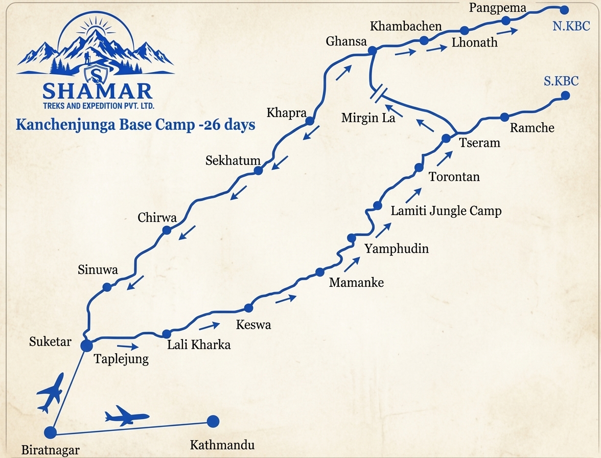
Route map image could not be loaded
Showing route for Kanchenjunga Base Camp Trek
Route Information
Starting Point:Sekathum
Ending Point:Khebang
Highest Point:Pangpema (North Base Camp) (5,143 m)
Key Locations
Sekathum
Day 2
start
1,660 m
Gyabla
Day 4
2,730 m
Ghunsa
Day 5
3,430 m
Khambachen
Day 7
4,050 m
Lhonak
Day 8
4,790 m
Pangpema
Day 9
viewpoint
5,143 m
Sele La Kharka
Day 11
4,290 m
Ramche
Day 13
4,580 m
Oktang
Day 14
viewpoint
4,730 m
Khebang
Day 17
end
1,910 m
Frequently Asked Questions
There are two. Pangpema, the north base camp, is 5,143 m and is the highest point of this trek. Oktang, the southern viewpoint below the Yalung glacier, is around 4,730 m. Kanchenjunga itself is 8,586 m, the third-highest mountain in the world.
Still have questions?
Our travel experts are here to help you plan the perfect trip. Get in touch with us for personalized advice.
Reviews & Ratings
—
0 reviews
5★
0
4★
0
3★
0
2★
0
1★
0
Share Your Experience
Have you completed this trek? Help other travelers by sharing your experience.