
Rara Lake, Nepal
Api Himal Base Camp Trek
Thirteen days into Darchula, the far north-west corner of Nepal, beneath Api at 7,132 m — a region that receives fewer trekkers in a year than Poon Hill sees on a good morning.
Package Overview
Best Time to Visit
April to June, September to November
Guided & Permitted
Licensed, insured guide and all trekking permits included
The least-trekked corner of Nepal, and why
Api stands at 7,132 m in Darchula district, hard against the borders with India and Tibet, and it is the highest mountain in far-western Nepal. The base camp beneath it sits at 3,850 m in a meadow that, for most of the year, has nobody in it at all.
The reason is not that the trek is bad. It is that Nepal's trekking industry grew up around Kathmandu and Pokhara, and the far west is a very long way from both. Getting here means a flight to Dhangadhi in the western Terai and then two days of driving on mountain roads. That journey is the barrier, and it is also the entire reason the valley is empty.
We will be direct: if your priority is the biggest mountains, go to Khumbu. If your priority is walking somewhere that almost no foreigner has walked, this is one of a very small number of genuine answers left in Nepal. The only comparable options we run are Makalu Base Camp in the east and the Upper Dolpo crossing — both bigger mountains, both considerably harder.
What "no infrastructure" means here
Stronger than on any other trek we sell. There are no teahouses on the route above Makarigaad. There is no rescue post, no bakery, no gear shop, no ATM after Dhangadhi, and no reliable mobile coverage for most of the walking days.
| Api Himal | Everest Base Camp | |
|---|---|---|
| Accommodation on trek | Homestays low down, tents higher | Lodges the whole way |
| Food | Carried and cooked by our crew | Ordered from a menu |
| Other trekkers | Realistically none | Thousands in season |
| Helicopter evacuation | Possible, slow, weather-dependent | Routine and fast |
| Nearest hospital | Dhangadhi, two days out | Kathmandu, hours |
| Guide local knowledge | Essential — few guides know this ground | Widely available |
We run this trek with a cook and a full camping crew from Sitigaun upwards, because there is no alternative and because anyone telling you otherwise has not been.
The altitude is modest; the remoteness is not
This is graded challenging, and it is worth being precise about where the difficulty actually lies. The high point is Kalidhunga Tal at about 4,200 m and base camp is 3,850 m — lower than Kyanjin Gompa, lower than Thorong La by well over a kilometre. Altitude sickness is a manageable risk here.
The difficulty is everything else. Long days on trails that are village paths rather than maintained trekking routes, steep and sustained climbs, river crossings, and the near-total absence of a safety net. A twisted ankle at 3,850 m on the Annapurna Circuit is an inconvenience. Here it is a serious logistical problem, and that is what raises the grade.
Api Base Camp, and the lakes above it
Base camp is a meadow at 3,850 m directly beneath the south face of Api, used seasonally by herders. It is not a mountaineering camp with fixed structures — it is grass, a water source and a very large mountain.
Above it, Kalidhunga Tal sits at around 4,200 m, a glacial lake that is the actual high point of the route and the better objective. Local tradition treats these lakes as sacred, and pilgrims come to them, so the usual courtesies apply: no swimming, no washing, and no leaving anything behind.
We schedule base camp and the lake for a single day from Dhauliodar, returning to sleep lower, which is both safer and the only option given where water and shelter are.
The journey in — two days you are paying for
Four of the thirteen days are travel, and there is no way around it.
A flight from Kathmandu to Dhangadhi in the far-western Terai, which is a short hop but subject to the same weather and scheduling that affects all domestic Nepali aviation. Then a full day's drive up to Dadeldhura, and another through Gokuleshwor to the roadhead at Makarigaad. Both drives are on winding hill roads, and the second is rough.
We build a buffer into the return for exactly this reason. A cancelled Dhangadhi flight is not unusual, and it should cost you a night in a hotel rather than your flight home.
Who lives in the far west
The lower valleys are Chhetri and Thakuri farming villages; higher and closer to the border are Byansi communities, a Bhotiya people with historic trade links across into Tibet and strong ties to the Indian side of the border at Vyas. This is culturally distinct from the Sherpa and Gurung Nepal that most trekking literature describes, and it is one of the genuine attractions of coming here.
It is also one of the poorest regions in the country and one where foreign visitors remain a novelty. A guide who speaks the local languages, and who has been before, changes this trek from an endurance exercise into a conversation.
Wildlife, and a real chance of seeing it
The Api Nampa Conservation Area spans an extraordinary altitude range — from around 518 m in the river valleys to 7,132 m at the summit of Api — and the forests in between are genuinely undisturbed, because there is no trekking traffic to disturb them.
Himalayan tahr and langur are common. Musk deer are present and occasionally seen. Bird life through the oak and rhododendron belt is excellent and largely unrecorded by visiting birders. If you carry binoculars on treks, carry them on this one.
Permits
- Api Nampa Conservation Area entry permit
- TIMS — Trekkers' Information Management System card
- A rural municipality entry permit is additionally required for the upper Vyas area near the border
All are included and arranged by us. Because this is a border region, carry your passport on your person rather than in a duffel — checks are occasional and conducted by the armed police rather than by park staff.
Season
April to June is the best window here, which sets this trek apart from most of Nepal. The far west gets less monsoon rain than the east but holds winter snow longer, so spring arrives late and stays good into June. Rhododendron through May is exceptional.
September to November also works, with clear air and cold nights. December to March closes the high ground with snow and empties the upper villages. We do not run this trek in July or August.
Where this trek goes
- Rara Lake — Nepal's largest lake, ringed by pine forest at 2,990 m in the far west
- Bardia National Park — Nepal's largest lowland park and its best chance of a wild tiger
Related activities: Trekking in Nepal, Bird Watching in Nepal.
Or compare every trip we run: all trekking and tour packages.
Trip Highlights
Api (7,132 m) — the highest peak in far-western Nepal, from its base camp
Kalidhunga Tal at about 4,200 m, the high point of the route
Api Nampa Conservation Area, spanning 518 m to 7,132 m of elevation
A trekking region with no commercial infrastructure and almost no visitors
Byansi and Chhetri villages far outside the trekking economy
Musk deer, Himalayan tahr and langur in undisturbed forest
Live Weather
Detailed Itinerary
1
Day 1: Kathmandu to Dhangadhi, drive to Dadeldhura (2,090 m)
A morning flight west to Dhangadhi in the Terai, close to the Indian border and about as far from the mountains as Nepal gets. Then four to five hours climbing by road into the hills to Dadeldhura, a district town on a ridge. A travel day, but the change of country between the plains and the hill towns is worth staying awake for.
2
Day 2: Dadeldhura to Makarigaad (1,300 m) via Gokuleshwor
Seven to eight hours of driving north on progressively rougher road through Gokuleshwor to the roadhead at Makarigaad. This is the last point vehicles reach and the last place with a shop. The crew loads here and the trek starts tomorrow. Overnight in a basic lodge or homestay.
3
Day 3: Makarigaad to Sitigaun (2,200 m)
Six to seven hours and the first walking day, climbing 900 m on a village trail beside the river through terraced farmland and into forest. These are working paths between settlements rather than a trekking route, and the difference in surface and marking is immediately obvious. Camp or homestay at Sitigaun.
4
Day 4: Sitigaun to Dhauliodar (3,100 m)
Five to six hours climbing steadily through oak and rhododendron into the upper forest, with the first proper views of the Api massif opening as the trees thin. Langur are common along this stretch and the birdlife is exceptional. Dhauliodar is high pasture with a water source — the base for the next two days, and a full camp from here on.
5
Day 5: Api Base Camp (3,850 m) and Kalidhunga Tal (about 4,200 m), return to Dhauliodar
The main day of the trek: seven to eight hours to the base camp meadow directly beneath the south face of Api, then higher to the glacial lake at Kalidhunga Tal, which is the actual high point of the route. The lakes are treated as sacred locally and pilgrims visit them, so no swimming or washing. Back down to sleep at Dhauliodar, which is both safer and where the water is.
6
Day 6: Dhauliodar — spare and exploration day
Held in reserve against weather, since a cloudy day at base camp removes the entire point of being there and this is a long way to come for a grey photograph. If day five went well, the alternative is a walk to the smaller lake at Ringdepani or up onto the ridge above camp for a wider view of the massif. Four to five hours either way.
7
Day 7: Dhauliodar to Sitigaun (2,200 m)
Four to five hours back down through the forest belt, losing 900 m. Easy going after two days of altitude, with the light behind you and the mountain at your back for the first hour. A good day for the birds you walked past on the way up.
8
Day 8: Sitigaun to Makarigaad (1,300 m)
Five to six hours descending the last of the trail to the roadhead, back through the farming villages and down to the river. Warm by the afternoon, and a noticeable return to green. Last night in the hills.
9
Day 9: Makarigaad to Dadeldhura (2,090 m)
Seven to eight hours of driving back down the rough road through Gokuleshwor and up to Dadeldhura. A long day in a vehicle and the price of the remoteness you came for. Hotel with hot water, which after a week of camping is not a small thing.
10
Day 10: Dadeldhura to Dhangadhi (109 m)
Four to five hours down out of the hills to the Terai and a dramatic change in temperature and vegetation — from oak forest to banana and sal within a few hours of descent. Overnight in Dhangadhi near the airport.
11
Day 11: Dhangadhi to Kathmandu
A short flight back east across the whole width of the country, with the Himalaya along the northern horizon for most of it if the weather is clear. Arrive in Kathmandu around midday and transfer to your hotel.
12
Day 12: Kathmandu — spare day
Reserved against a cancelled Dhangadhi flight, which happens often enough to plan for. If everything ran to schedule, this is a free day in Kathmandu and we can arrange a guided tour of the valley or simply point you at the best places to eat after two weeks of camp food.
13
Day 13: Departure
Transfer to Tribhuvan International Airport, timed to your flight. If you are staying on in Nepal we are happy to help arrange onward travel, whether that is Chitwan, Pokhara or a few days doing nothing beside Phewa lake.
Cost Details
What's Included
- Return flights, Kathmandu to Dhangadhi
- All road transport, Dhangadhi to Makarigaad and return
- Full camping crew: cook, kitchen staff and porters
- All tents, kitchen equipment and camp meals
- Homestay or lodge accommodation where available on the lower trail
- Api Nampa Conservation Area permit, rural municipality permit and TIMS card
- Licensed, insured English-speaking guide who has walked this route
- Crew wages, insurance, food and accommodation
- Comprehensive first aid kit and pulse oximeter carried by the guide
- One spare day at Dhauliodar and one spare night in Kathmandu
- Government taxes and company service charge
What's Not Included
- International flights and Nepal visa
- Travel insurance — must cover helicopter evacuation, and we will ask to see it
- Accommodation and meals in Kathmandu beyond the spare night
- Personal trekking equipment, sleeping bag rated to -10°C and sleeping mat
- Bottled drinks and any charging
- Tips for guide, cook and porters
- Any cost arising from flight cancellation, early descent or evacuation
Essential Information
- Maximum altitude: 4,200 m
- Trip duration: 13 days
- Difficulty: challenging
- Best season: April to June, September to November
- Group size: 2 to 8 trekkers
- Permits: Api Nampa Conservation Area permit; Rural municipality entry permit for upper Vyas; TIMS card — all included and arranged by us
- Accommodation: Full camping above Sitigaun, homestays lower down
- Guide: licensed and insured, English speaking
- Weather reference point: Dhauliodar
Important Cost Information
Payment Terms:
- • 25% deposit required to confirm booking
- • Balance payment due 30 days before departure
- • Full refund if cancelled 45+ days before
Fixed Departure Dates
Choose from our scheduled group departures with guaranteed departures.
Route Map
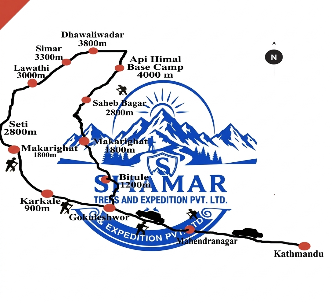
Route map image could not be loaded
Showing route for Api Himal Base Camp Trek
Route Information
Starting Point:Makarigaad
Ending Point:Makarigaad
Highest Point:Kalidhunga Tal (4,200 m)
Key Locations
Makarigaad
Day 2
start
1,300 m
Sitigaun
Day 3
2,200 m
Dhauliodar
Day 4
3,100 m
Api Base Camp
Day 5
landmark
3,850 m
Kalidhunga Tal
Day 5
viewpoint
4,200 m
Frequently Asked Questions
Api Base Camp is 3,850 m. The highest point of the trek is actually Kalidhunga Tal, a glacial lake at about 4,200 m above the base camp, which we visit on the same day. Api itself is 7,132 m and is the highest peak in far-western Nepal.
Still have questions?
Our travel experts are here to help you plan the perfect trip. Get in touch with us for personalized advice.
Reviews & Ratings
—
0 reviews
5★
0
4★
0
3★
0
2★
0
1★
0
Share Your Experience
Have you completed this trek? Help other travelers by sharing your experience.