
Annapurna Region, Nepal
Nar Phu Valley Trek
Twelve days into two Tibetan villages that were closed to outsiders until 2002, reached through a gorge and left over the 5,320 m Kang La — the emptiest corner of the Annapurna region.
Package Overview
Best Time to Visit
March to May, September to November
Guided & Permitted
Licensed, insured guide and all trekking permits included
A valley that was closed until 2002
Nar and Phu sit in a side valley off the Annapurna Circuit that was sealed to foreigners for reasons of border sensitivity until 2002. Two decades later it is open, but only under a restricted-area permit, and the practical result is that a trail two days' walk from one of the busiest routes in Nepal carries almost no one.
What is up there is not a scenic substitute for the Circuit. It is a pair of Tibetan-culture villages at over 4,000 m — Phu at 4,080 m under the ruins of a hilltop fortress, Nar at 4,110 m behind a row of chortens — that have kept a way of life the main valley largely traded away. Yak herding, barley, salt-route memory, and a working monastery that sees a handful of visitors a week.
The permit rules, and why they decide your trip
This matters before anything else, because the rules are not negotiable and they catch people out.
| Rule | What it means for you |
|---|---|
| Restricted Area Permit required | Issued only through a registered Nepali agency — you cannot buy one yourself |
| No minimum party size | Since March 2026 a solo trekker can be permitted individually |
| Licensed guide mandatory | Not a recommendation here; a condition of the permit |
| Fee varies by season | Higher in the September–November window than the rest of the year |
| ACAP also required | The valley sits inside the Annapurna Conservation Area |
| Permit is date-bound | Issued for specific dates; changing them means re-issuing |
We handle all of it, and the cost of both permits is in the price. The one thing we cannot solve is the minimum party size — if you are travelling alone, tell us early and we will try to place you on an existing departure rather than leave you to discover the rule at the permit office.
Be sceptical of any operator quoting you a solo Nar Phu trek. Either they are joining you to a group without saying so, or the permit is not what they claim.
How hard it is, and the two things that make it so
Challenging. Not technical — there is no rope, no crampons and no climbing — but two factors raise this well above a standard teahouse trek.
Altitude. You sleep above 3,500 m from day four and above 4,000 m for three consecutive nights, then cross a 5,320 m pass. That is a serious profile and the reason day seven exists as a rest day at Phu rather than a sightseeing extra.
The pass itself. Kang La is a long morning: a pre-dawn start, a sustained climb on scree and, in early or late season, snow. The descent on the Manang side is steep and loose. It is the hardest single day and everything before it is preparation for it.
A note on the height of Kang La
You will see Kang La listed as 5,416 m on a number of trekking sites. That is the height of Thorong La, copied across in error. The Nar Phu Kang La is 5,320 m. It is a small thing, but an operator who has not noticed it has not checked their own page.
The gorge, and what the walking is actually like
The approach from Koto is not a valley walk. The Phu Khola runs through a deep, narrow gorge and the trail is cut into the cliff above it, crossing and re-crossing on suspension bridges, with sections of exposed path and a good deal of noise from the river below.
It is dramatic and it is genuinely narrow in places. It is also completely manageable if you are steady on your feet and not badly affected by exposure. If heights trouble you, say so and your guide will position accordingly — this is one of the few Nepali trails where that is a real conversation rather than a formality.
Above the gorge the country changes entirely: the trees stop, the valley opens, and you are in dry high-altitude terrain that looks and feels like Tibet, because geographically it very nearly is.
Phu, Nar, and the days that are not about walking
Phu is reached on day six and you stay two nights. The village sits below a ruined fortress — a reminder that this valley controlled a trade route and needed defending. Below it is Tashi Lhakhang Gompa, a working monastery in one of the remotest inhabited settings in Nepal, where a visit means sitting quietly rather than touring.
Nar is a half-day's walk on and feels different — more agricultural, four gompas, a long approach past a line of chortens that is the most photographed thing in the valley for good reason.
The acclimatisation day at Phu is not padding. It is the day that decides whether Kang La goes well, and we use it to walk high and come back down.
Adding the Annapurna Circuit
Kang La drops you into Ngawal, which is on the Annapurna Circuit trail a day short of Manang. That makes this trek a natural front end to the Circuit rather than a detour from it.
The combined trip runs to about seventeen or eighteen days and crosses two passes over 5,300 m, with the Nar Phu section doubling as acclimatisation for Thorong La. It is the best version of the Annapurna Circuit available, and if you have the time we would encourage it over either trek alone — see the Annapurna Circuit with Tilicho Lake for what the second half looks like, and ask us to price the two together.
Lodges at 4,000 m
Basic and few. Nar and Phu have simple community-run lodges and homestays; Meta and Kyang have a handful of rooms between them. Nothing up here has heating beyond the dining room stove, hot water is a bucket if it exists at all, and the menu is short.
Because capacity is genuinely limited and the season is compressed, we book. In October there is no slack in this valley.
Season
September to November is the main window: stable weather, Kang La usually clear of deep snow, and the villages fully inhabited. March to May works well and is quieter still, though the pass can hold snow into April.
Winter effectively closes the valley — Nar and Phu partially empty as families move lower, and Kang La becomes a mountaineering proposition rather than a trekking one. The monsoon is poor for the usual reasons plus one specific: the gorge section is rockfall-prone in heavy rain.
Where this trek goes
- Pokhara — A lakeside town at 820 m with the Annapurnas 30 km away
Related activities: Trekking in Nepal.
Or compare every trip we run: all trekking and tour packages.
Trip Highlights
Kang La (5,320 m) with Annapurna II and the Manang valley laid out below
Phu (4,080 m) and Nar (4,110 m) — Tibetan villages closed to foreigners until 2002
Tashi Lhakhang Gompa, one of the most remote working monasteries in Nepal
A gorge approach on trail cut into the cliff face
Restricted-area trekking: limited permits, almost no other groups
Finishes into Manang, so the Annapurna Circuit can be added on
Live Weather
Detailed Itinerary
1
Day 1: Kathmandu to Jagat (1,300 m)
A long drive of eight to nine hours west and then north up the Marsyangdi valley through Besisahar, the last stretch on rough road. Jagat is a stone-built village on a shelf above the river and the first night of the trek proper. Permits are checked here, which is also the first time the restricted-area paperwork gets used.
2
Day 2: Jagat to Dharapani (1,860 m)
Drive or walk, depending on road conditions and preference — the jeep track continues and most groups now ride the rough section, saving a day of roadside walking for the parts worth doing. Around four hours either way. Dharapani sits at the junction where the Manaslu Circuit comes in from the west.
3
Day 3: Dharapani to Koto (2,600 m)
Five to six hours up the Marsyangdi through pine and fir, with Annapurna II appearing ahead as the valley bends. Koto is a small village on the Circuit trail and the gateway to the restricted valley — the checkpost here is where the Nar Phu permit is registered and where the crowds stop.
4
Day 4: Koto to Meta (3,560 m)
The gorge day, and a long one at seven to eight hours. The trail turns north off the Circuit and immediately enters the Phu Khola gorge — cut into the cliff, crossing suspension bridges, with exposed sections and the river loud below. It climbs steadily out of the trees to Meta, a windswept settlement on an open plateau. The change of country in one day is remarkable.
5
Day 5: Meta to Kyang (3,820 m)
Five to six hours through dry high country past Chyako, with the ruins of old Khampa settlements — built by Tibetan resistance fighters who used this valley in the 1960s — on the slopes above. Kyang is a small cluster of buildings with big views up towards the Himlung massif. Short on comfort, long on atmosphere.
6
Day 6: Kyang to Phu (4,080 m)
Five to six hours following the river through a narrowing canyon before the valley finally opens and Phu appears, stacked on a bluff below its ruined fortress. It is one of the great first sights in Nepali trekking. Afternoon to arrive slowly, drink tea and let the altitude settle.
7
Day 7: Phu — acclimatisation and Tashi Lhakhang Gompa
A rest day that is not a rest. We walk high — up towards the Himlung base camp trail or the ridge above the village, gaining several hundred metres — and come back down to sleep, which is what makes Kang La possible three days later. The afternoon is for Tashi Lhakhang Gompa below the village, a working monastery in one of the remotest inhabited settings in the country. Visiting means sitting quietly, not touring.
8
Day 8: Phu to Nar (4,110 m)
Six to seven hours back down the valley and then up the side branch to Nar, the last hour climbing past a long line of chortens with the village behind them. Nar is more agricultural than Phu and has four gompas. Same altitude, entirely different feel. An easier day by design — this is the last one before the pass.
9
Day 9: Nar to Kang La Phedi (4,530 m)
A short day of three to four hours climbing to the base of the pass. Deliberately minimal: the point is to sleep as high as is sensible so that the pass morning is shorter, without adding fatigue. Basic accommodation or tented camp depending on the season and what is open.
10
Day 10: Kang La (5,320 m) to Ngawal (3,660 m)
The big day. Away before dawn for a steady three to four hour climb on scree and, early or late in the season, snow. From the top the Annapurna range and the whole Manang valley open up — Annapurna II, Gangapurna, Tilicho Peak. Then a steep, loose descent of more than 1,600 m to Ngawal on the Annapurna Circuit trail. Seven to nine hours in total and hard on the legs.
11
Day 11: Ngawal to Chame, drive to Besisahar
Four to five hours down the Circuit trail through Braga and Pisang — easy walking on a good path, and a strange re-entry into a world with other trekkers in it. From Chame a jeep takes you down to Besisahar, around four hours on rough road. Overnight in a lodge.
12
Day 12: Besisahar to Kathmandu
Six to seven hours by road, mostly sealed, arriving in Kathmandu in the afternoon. Drop-off at your hotel. If you would rather finish in Pokhara, the drive is shorter and we can route you that way at no extra cost.
Cost Details
What's Included
- Private vehicle, Kathmandu to Jagat and Besisahar to Kathmandu
- Jeep transfers on the rough Dharapani and Chame sections
- Restricted Area Permit for Nar and Phu
- ACAP entry permit and TIMS card
- All accommodation on trek in lodges and homestays, twin share
- Breakfast, lunch and dinner throughout the trek
- Rooms booked in advance, where valley capacity is limited
- Licensed, insured English-speaking guide experienced on Kang La
- Guide wages, insurance, equipment, food and accommodation
- First aid kit and pulse oximeter carried by the guide
- Government taxes and company service charge
What's Not Included
- International flights and Nepal visa
- Travel insurance — must cover helicopter evacuation to 5,500 m
- Accommodation and meals in Kathmandu
- Porter — strongly recommended, available at a daily rate
- Hot water, charging and bottled drinks in the upper valley
- Personal trekking equipment and a sleeping bag rated to -15°C
- Annapurna Circuit extension, quoted separately
- Tips for guide and porter
- Any cost arising from early descent, evacuation or a closed pass
Essential Information
- Maximum altitude: 5,320 m
- Trip duration: 12 days
- Difficulty: challenging
- Best season: March to May, September to November
- Group size: 2 to 10 trekkers
- Permits: Restricted Area Permit for Nar and Phu — issued only through a registered agency; ACAP entry permit; TIMS card — all included and arranged by us
- Accommodation: Basic lodges and homestays, tented camp at Kang La Phedi
- Guide: licensed and insured, English speaking
- Weather reference point: Phu
Important Cost Information
Payment Terms:
- • 25% deposit required to confirm booking
- • Balance payment due 30 days before departure
- • Full refund if cancelled 45+ days before
Fixed Departure Dates
Choose from our scheduled group departures with guaranteed departures.
Route Map
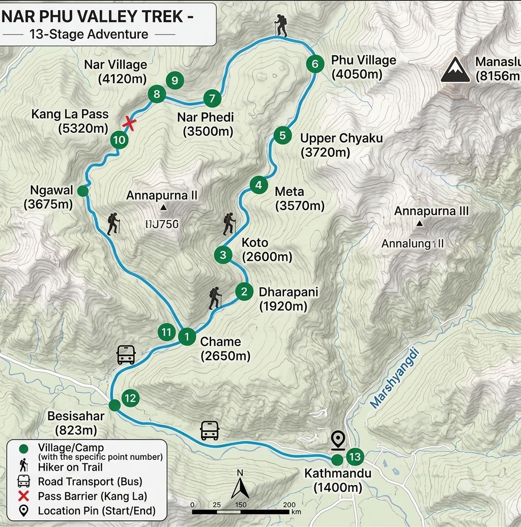
Route map image could not be loaded
Showing route for Nar Phu Valley Trek
Route Information
Starting Point:Koto
Ending Point:Ngawal
Highest Point:Kang La (5,320 m)
Key Locations
Koto
Day 3
start
2,600 m
Meta
Day 4
3,560 m
Kyang
Day 5
3,820 m
Phu
Day 6
4,080 m
Nar
Day 8
4,110 m
Kang La Phedi
Day 9
4,530 m
Kang La
Day 10
landmark
5,320 m
Ngawal
Day 10
end
3,660 m
Frequently Asked Questions
Yes. Nar Phu is a restricted area and requires a Restricted Area Permit, which can only be issued through a registered Nepali trekking agency — you cannot obtain one yourself. You also need an ACAP entry permit. Both are included in the price and arranged by us.
Still have questions?
Our travel experts are here to help you plan the perfect trip. Get in touch with us for personalized advice.
Reviews & Ratings
—
0 reviews
5★
0
4★
0
3★
0
2★
0
1★
0
Share Your Experience
Have you completed this trek? Help other travelers by sharing your experience.