
Annapurna Region, Nepal
Annapurna Circuit with Tilicho Lake
Eleven days around the Annapurna massif taking in Tilicho Lake at 4,919 m and the Thorong La at 5,416 m — starting at Chame by jeep so the walking begins where the trail is still a trail.
Package Overview
Best Time to Visit
March to May, September to November
Guided & Permitted
Licensed, insured guide and all trekking permits included
Why this itinerary is eleven days and not twenty-one
If you have read an older guidebook, the Annapurna Circuit is a three-week walk starting at Besisahar. That trek no longer exists in the form it describes. A road now runs up the Marsyangdi valley to Manang and down the far side from Muktinath, and the first four or five days of the classic route are spent walking on or beside it.
We start at Chame (2,710 m) by jeep. What you lose is roadside walking. What you keep is every part of the circuit that people actually remember: the Manang valley, Ice Lake, Tilicho, the pass, and the descent into Mustang.
Be wary of an operator selling you a 21-day circuit without explaining what you will be walking alongside for the first week. The honest version of this trek in 2026 is between ten and fourteen days.
Who this trek suits
You need to be able to walk six to eight hours on consecutive days, and you need eleven days you can commit to without a fixed flight at the end. There is no technical ground — no rope, no crampons, no climbing.
What you cannot prepare for is altitude. This itinerary sleeps above 3,500 m from day three onward and crosses 5,416 m on day ten. Fitness does not predict how you handle that, which is why the acclimatisation days are not optional extras.
| You will probably enjoy this if | Consider something shorter if |
|---|---|
| You have trekked multi-day before, at any altitude | This is your first multi-day walk anywhere |
| You want a high pass rather than an out-and-back | You have fewer than ten clear days |
| You are comfortable with basic lodges and cold nights | You need a hot shower every night |
| You can add a buffer day at the end | Your international flight is fixed and tight |
If the second column describes you, Poon Hill or Mardi Himal give you the Annapurnas in four days without the altitude commitment.
The acclimatisation plan, and why it is shaped this way
Three of the eleven days exist for acclimatisation rather than distance, and they are the reason people finish this trek.
Day 4 in Manang (3,519 m) is a rest day with a short walk. Sleeping height does not change. This single day does more for your chances on the pass than any training you did at home.
Day 5 climbs Ice Lake to around 4,600 m and comes back down to sleep at 3,519 m. Climb high, sleep low — the most effective acclimatisation tool available without drugs, and the day most cheap itineraries cut.
Day 7 is Tilicho, up to 4,919 m and back down to Shree Kharka. Same principle, higher.
By the time you reach Thorong High Camp on day nine you have already been above 4,900 m twice and slept progressively higher. That is the plan working.
What we do if it is not working
Your guide carries a pulse oximeter and will check you morning and evening above 4,000 m. If you develop symptoms of acute mountain sickness that do not resolve with a rest day, we descend. Not negotiable, and not refundable against the mountain — but our guides are instructed that turning a client around is the correct decision, never a failure.
Tilicho: the part that needs honest discussion
Tilicho Lake sits at 4,919 m and is one of the highest lakes of its size anywhere. It is also reached by a traverse across a notoriously loose landslide section between Khangsar and Tilicho Base Camp — an eroding slope of scree and rock that shifts, and where rockfall is a genuine hazard rather than a theoretical one.
We cross it early, before the sun loosens the slope, and we do not cross it at all after heavy rain or fresh snow. If conditions are wrong on the day, we skip Tilicho and use the extra time at Manang. That decision is made on the ground by the guide, not in an office in advance, and it is one of the questions worth asking any operator you are comparing us with.
Thorong La
The pass is crossed from Thorong High Camp (around 4,850 m) starting between 4 and 5 am. The early start is partly for snow conditions and partly because the wind on the pass rises predictably through the morning.
It is a long day — four to six hours up, then a descent of more than 1,600 m to Muktinath on the far side, which is harder on knees than the climb is on lungs. Trekking poles matter more here than anywhere else on the route.
The pass can close after heavy snowfall. If it does, the only alternative is to retrace down the Marsyangdi, which is why we ask you to keep a spare day at the end of the trip.
Permits, and what they cost
Two are required for this route:
- ACAP — Annapurna Conservation Area Project entry permit
- TIMS — Trekkers' Information Management System card
Both are included in the package price and we arrange them in Pokhara or Kathmandu. You need your passport and passport photographs. Checkpoints at Chame, Manang and Jomsom will ask for both, and the Manang checkpoint records your details for search and rescue purposes.
The kit that decides how the pass day goes
Most of what you read about packing for this trek is a list. The useful version is much shorter, because on the Thorong La morning only four things change the outcome.
| Item | Why it decides the day |
|---|---|
| Sleeping bag to -10°C or lower | A sleepless night at High Camp is the most common reason people turn back |
| Insulated gloves plus thin liners | You cannot manage zips, poles or a camera in thick gloves alone, and bare hands at -15°C is a matter of minutes |
| Windproof shell, top and bottom | The pass is a wind funnel; still air at High Camp says nothing about conditions 500 m higher |
| Trekking poles | For the 1,600 m descent afterwards, not the climb |
Boots matter too, but they matter from day one and you should arrive with them broken in. Buying boots in Kathmandu the day before an eleven-day trek is the single most reliable way to ruin it.
Renting in Pokhara or Kathmandu
Down jackets and sleeping bags are worth renting rather than flying with — shops in both cities rent by the day at modest rates and the quality is adequate, though sizing for taller trekkers is limited. Inspect the zip on any bag before you accept it.
What we would not rent: boots, gloves and waterproofs. Fit and condition matter too much on those, and the rental stock sees hard use.
What a day actually looks like
Breakfast between 7 and 8. Walking by 8. Three to four hours to a lunch stop, an hour there while food is cooked to order, then two to three hours to the night's lodge, arriving mid-afternoon. Tea, a wash if there is hot water, dinner around 6.30, and most people are asleep by 9.
Lodges are simple: a twin room with wooden walls and no heating, a shared bathroom, and a dining room with a stove that is lit in the evening. Above Manang the rooms get colder and the menus shorter. Bring a sleeping bag rated to at least -10°C.
Where this trek goes
- Muktinath & Jomsom — A temple at 3,800 m held sacred by Hindus and Buddhists alike, in the arid Kali Gandaki valley
- Pokhara — A lakeside town at 820 m with the Annapurnas 30 km away
Related activities: Trekking in Nepal.
Or compare every trip we run: all trekking and tour packages.
Trip Highlights
Thorong La (5,416 m) — the high point of the classic circuit
Tilicho Lake (4,919 m), among the highest large lakes in the world
Ice Lake (4,600 m) as an acclimatisation climb from Manang
Braga monastery, the oldest in the Manang valley
Muktinath, sacred to both Hindus and Buddhists
Starts at Chame by jeep — no days walking beside the road
Live Weather
Detailed Itinerary
1
Day 1: Kathmandu to Chame (2,710 m)
A long drive day — roughly nine to ten hours by private jeep via Besisahar and up the Marsyangdi valley. The road is sealed as far as Besisahar and rough after it. Starting here means the trek begins where the walking is worth doing. Overnight in a lodge at Chame, the administrative centre of Manang district, with hot springs beside the river.
2
Day 2: Chame to Pisang (3,200 m)
Four to five hours through pine forest with the Paungda Danda rock face — a vast curved slab rising more than 1,500 m from the valley floor — dominating the afternoon. The valley narrows and then opens as you approach Pisang. First night above 3,000 m, and the first night you may notice the altitude.
3
Day 3: Pisang to Manang (3,519 m) via the Ghyaru high route
Five to six hours. We take the upper trail through Ghyaru and Ngawal rather than the valley floor — it is a harder climb and several hundred metres higher, and it is the single best half-day of views on the circuit, with Annapurna II and IV across the valley. It is also better acclimatisation than the flat route.
4
Day 4: Manang — acclimatisation day
No change in sleeping altitude. A short walk to Gangapurna Lake and the glacier viewpoint above it, then time in Manang itself — a genuinely interesting Tibetan-influenced town with a Himalayan Rescue Association aid post that runs a free altitude sickness talk most afternoons in season. Worth attending.
5
Day 5: Ice Lake (4,600 m) and Braga monastery, back to Manang
The hardest day so far and the most valuable. A steep climb of around 1,100 m to Kicho Tal, the Ice Lake, then back down to sleep at Manang. On the return we stop at Braga, the oldest monastery in the valley, with a gallery of statues several centuries old. Climb high, sleep low.
6
Day 6: Manang to Tilicho Base Camp (4,150 m)
Five to six hours via Khangsar. The afternoon includes the landslide traverse — a loose scree slope that the guide will assess before committing. We cross it in the morning shade where possible. Base camp is a cluster of lodges in an exposed bowl; it is cold and the nights are long.
7
Day 7: Tilicho Lake (4,919 m), then trek to Shree Kharka (4,050 m)
A pre-dawn start for the climb to the lake — around three to four hours up, on a steady zigzag with no technical ground. Tilicho is frozen for much of the year and the colour when it is not is remarkable. Back down to base camp for a late breakfast, then on to Shree Kharka to sleep lower. A long day but the altitude profile is right.
8
Day 8: Shree Kharka to Yak Kharka (4,050 m)
A shorter day, four to five hours, contouring across open hillside back towards the main circuit trail. Blue sheep are common on these slopes and lammergeier are often overhead. Deliberately easy — this is recovery before the pass.
9
Day 9: Yak Kharka to Thorong High Camp (4,850 m)
Three to four hours and only around 800 m of gain, but at this altitude it is enough. We stop at Thorong Phedi for lunch and then make the steep short climb to High Camp. Sleeping at High Camp rather than Phedi shortens the pass day considerably, though it is a colder and less comfortable night.
10
Day 10: Thorong La (5,416 m) to Muktinath (3,760 m)
The big day. Away between 4 and 5 am by headtorch, four to six hours to the pass with prayer flags and a tea shack at the top. Then a descent of over 1,600 m into the Mustang rain shadow, arriving at Muktinath in the afternoon. Time at the temple complex and its 108 water spouts in the evening or next morning.
11
Day 11: Muktinath to Pokhara
Jeep down the Kali Gandaki through Kagbeni and Jomsom, then on to Pokhara — a long day on rough road, roughly eight to ten hours. An alternative is the short flight Jomsom to Pokhara, which we can arrange at additional cost; it leaves at dawn and is weather-dependent, so the road remains the reliable option.
Cost Details
What's Included
- Airport transfers in Kathmandu and Pokhara
- Private jeep, Kathmandu to Chame on day 1
- Jeep, Muktinath to Pokhara on day 11
- All lodge accommodation on trek, twin share
- Breakfast, lunch and dinner throughout the trek
- Licensed, insured English-speaking trekking guide
- ACAP entry permit and TIMS card
- Guide wages, insurance, equipment, food and accommodation
- First aid kit and pulse oximeter carried by the guide
- Government taxes and company service charge
What's Not Included
- International flights and Nepal visa
- Travel insurance — must cover helicopter evacuation to 6,000 m
- Accommodation and meals in Kathmandu and Pokhara
- Porter — available on request, approximately per day
- Hot showers, wifi, battery charging and bottled drinks in lodges
- Optional Jomsom to Pokhara flight in place of the jeep
- Personal trekking equipment and sleeping bag
- Tips for guide and porter
- Any cost arising from early descent, evacuation or trip changes
Essential Information
- Maximum altitude: 5,416 m
- Trip duration: 11 days
- Difficulty: challenging
- Best season: March to May, September to November
- Group size: 1 to 12 trekkers
- Permits: ACAP entry permit; TIMS card — all included and arranged by us
- Accommodation: Lodges on trek, twin share
- Guide: licensed and insured, English speaking
- Weather reference point: Manang
Important Cost Information
Payment Terms:
- • 25% deposit required to confirm booking
- • Balance payment due 30 days before departure
- • Full refund if cancelled 45+ days before
Fixed Departure Dates
Choose from our scheduled group departures with guaranteed departures.
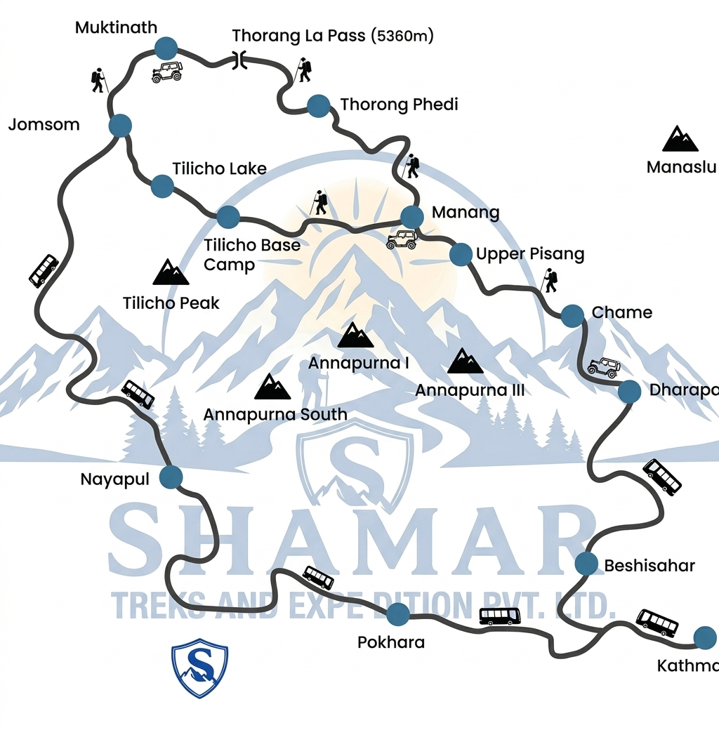
Route Map
Route map image could not be loaded
Showing route for Annapurna Circuit with Tilicho Lake
Route Information
Starting Point:Chame
Ending Point:Muktinath
Highest Point:Thorong La (5,416 m)
Key Locations
Chame
Day 1
start
2,710 m
Pisang
Day 2
3,200 m
Manang
Day 3
3,519 m
Ice Lake
Day 5
viewpoint
4,600 m
Tilicho Base Camp
Day 6
4,150 m
Tilicho Lake
Day 7
viewpoint
4,919 m
Thorong High Camp
Day 9
4,850 m
Thorong La
Day 10
landmark
5,416 m
Muktinath
Day 10
end
3,760 m
Frequently Asked Questions
Challenging rather than technical. The difficulty comes from altitude, consecutive long days and one 5,416 m pass — not from the terrain, which requires no equipment or skill. Adding Tilicho raises the maximum altitude reached before the pass, which actually improves your acclimatisation, but it adds two hard days.
Still have questions?
Our travel experts are here to help you plan the perfect trip. Get in touch with us for personalized advice.
Reviews & Ratings
—
0 reviews
5★
0
4★
0
3★
0
2★
0
1★
0
Share Your Experience
Have you completed this trek? Help other travelers by sharing your experience.